Category Archives: trails|san gabriels

Snow, Sadie and Mt. Baden-Powell

View southwest from Sadie Hawkins past Twin Peaks to Mt. Wilson
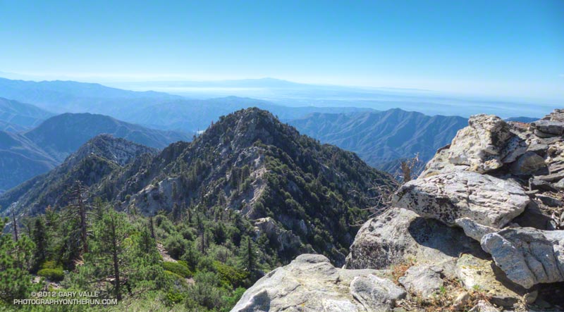
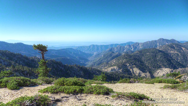
View Southwest from Middle Hawkins past Twin Peaks to Mt. Wilson

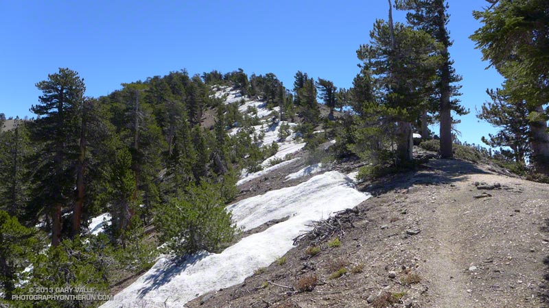
The snow was rock hard and covered with lodgepole pine needles and other debris. Having experience climbing snow and ice I can usually deal with a little early season snow, but I could see no way to safely cross this patch. The snow was steep and icy, the runout long and the risk high. My usual tricks for crossing short stretches of snow were not going to work.

Snowfall had been sporadic in Southern California over the Winter and this was the earliest in the Spring I had tried to do the out and back from Islip Saddle to Mt. Baden-Powell. I had thought there might be some patchy snow on the north-facing slopes at the higher elevations, but I hadn’t expected it to be an issue.


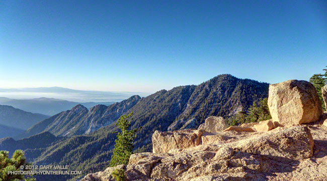
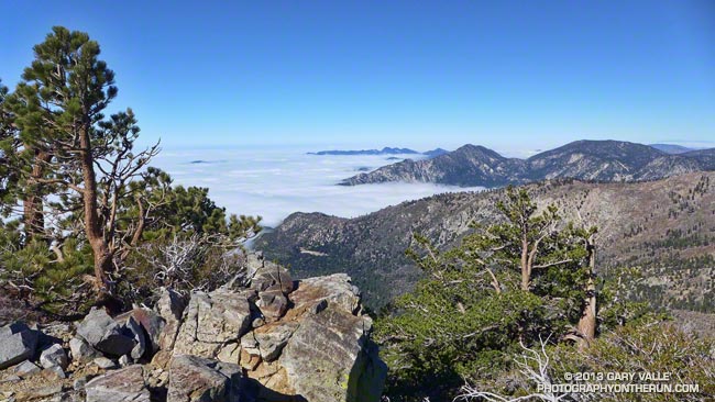
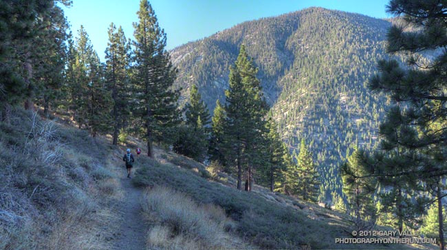
Borrowing from river paddling philosophy, you never run (or hike, or ride) the same trail twice. I knew it was going to be an interesting day when a bighorn sheep darted from the trailhead at the beginning of the run. I’d followed bighorn tracks from Islip Saddle up the PCT for about a quarter mile to an overlook of Hwy 39 and Twin Peaks.

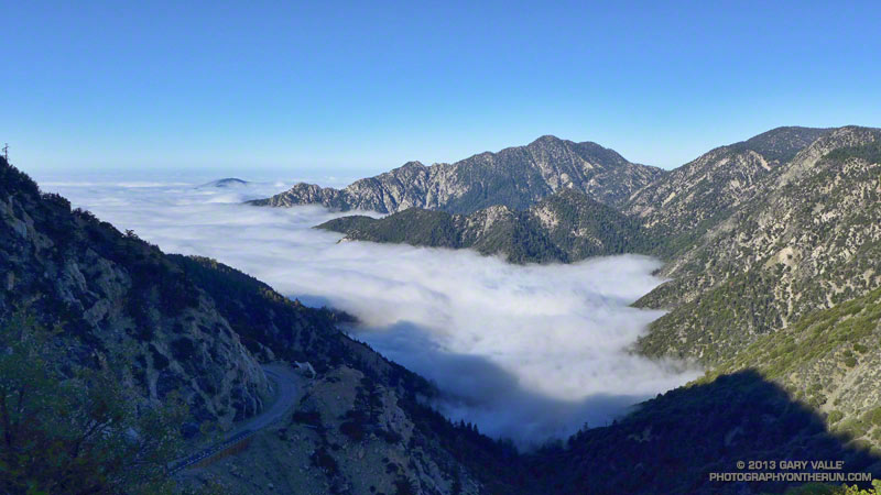
The view from the overlook had been spectacular. Marine layer stratus filled the canyon, nearly immersing Triplet Rocks on Twin Peak’s elongated east ridge. The stratus was evidence of a strong onshore flow, but above Islip Saddle a strong — and cold — wind was blowing almost directly out of the north. It had been cold enough that I pulled on my extra sleeves, ultralight shell and light gloves.

The wind was unrelenting and seemed to work its way around every corner and into every canyon. At Windy Gap and the other wind gaps along the crest the wind was funneled and accelerated, and I wondered if this would be the day I would see or hear one of the huge ghost trees from the Curve Fire crash to the ground.


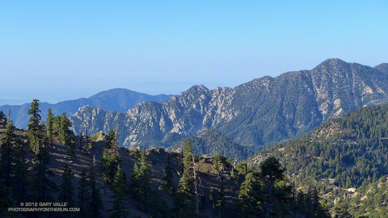
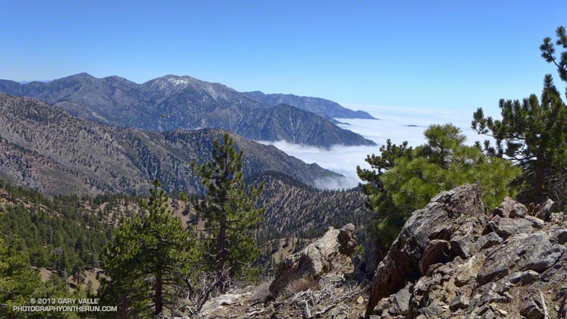
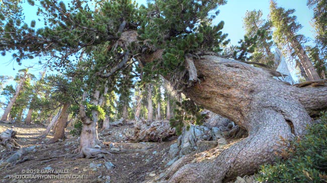
At times I go where my camera takes me, and about a half-mile west of Mt. Hawkins it took me off the PCT and onto the Hawkins Ridge Trail. There are three peaks along this ridge —  Middle Hawkins, Sadie Hawkins and South Mt. Hawkins. It had been years since I’d done these peaks, and today it looked like there might be some good views from the ridge.

The Hawkins Ridge Trail was warm and mostly sheltered from the wind and I continued down the trail a little further than necessary before leaving it and scrambling up to the summit of Middle Hawkins. Warmed from the steep climb I had returned to the PCT and continued toward Baden-Powell.


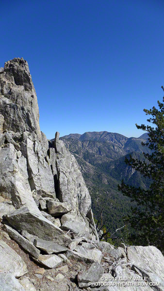
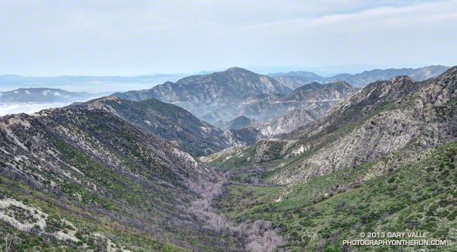
Near the junction of the PCT and Dawson Saddle Trail there had been patches of snow mixed in with the chinquapin and limber pines, but it hadn’t been until the PCT skirted north around Mt. Burnham that the trail was blocked by snow. I abandoned the attempt to cross the icy patch and headed up the steep slopes of Mt. Burnham to the crest.

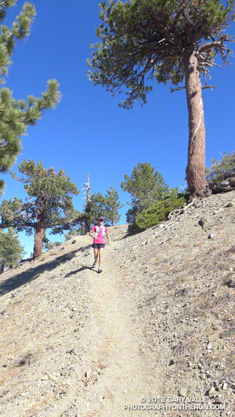
It was still cold and windy when I reached the summit of Mt. Baden-Powell, but a sparkling day with Mt. Baldy to the southeast across Vincent Gulch, San Jacinto Peak and San Gorgonio area peaks in the distance to the southeast, the Sierra to the north, and miles of stratus to the south. After spending a few minutes on the summit I retraced my steps back down the crest and the PCT to Islip Saddle, making the requisite stop at Little Jimmy Springs along the way.

Some related posts: San Gabriels High Five, La Nina Looming, Running Hot & Cold, Toward Triplet Rocks

Unwinding from the Backbone Ultra

Bear Canyon
Bear Canyon

Doing a moderate run in the San Gabriels and climbing a few peaks was a great way to unwind from the excitement of doing the 68 mile Backbone Ultra last weekend.

I felt good. I’d run more or less normally in the week following the event — depleted, but without any physical issues. In part that can be attributed to how Coyote Cohorts runs their events. It was basically a long training run in the company of a great bunch of runners and the help of incredible volunteers. Amazing! The long hours of training also really helped, particularly the back-to-back runs following 50Ks and the back-to-back night/day training runs. My shoes — Hoka Mafate 2s — also helped, reducing the impact of all the miles.

Paintbrush on the San Gabriel Peak Trail near Markham Saddle.
Paintbrush on the San Gabriel Peak Trail

One of the reasons for doing today’s run was to check how Poodle-dog Bush and some other plants are faring in this low rainfall water year. Since July 1 Downtown Los Angeles has recorded only 5.14 inches of rain. Unless we can manage to wring about a half-inch of rain from the heavens before June 30, this water year will go down as the fourth driest since record-keeping began in 1877. The driest water year on record was in 2005-2006 (3.21 inches). Assuming we don’t get that 0.48 inch of rain, three of the four driest water years have occurred since 2000.

Something I noticed on the Backbone run and recent training runs in the Santa Monica Mountains is that plant growth and flowering has been surprisingly robust given the amount of rainfall. This was also the case today on today’s run — the manzanita on the San Gabriel Peak Trail was covered in blossoms and bees, and the nightshade and paintbrush along the trail also seemed to be doing well.

Prickly phlox along Calabasas Peak Mtwy.

What about the Poodle-dog bush, aka Turricula? It looked about the same as last year at this time — just starting to come out of Winter dormancy. Last year we had above average rainfall in April and it really seemed to spur the growth of Poodle-dog bush. This year maybe we’ll see what an extended period of dry weather does to it. Last year some of the Poodle-dog died before the rain in April.

Here’s a short slideshow of a few photos from today’s run in the San Gabriel Mountains, as well as some photos of plants and flowers on recent runs in the Santa Monica Mountains.

Throop Peak Limber Pines

A nearly pure stand of limber pines on the north slopes of Throop Peak in the San Gabriel Mountains near Los Angeles.

Limber pines can be very long-lived. The Rocky Mountain Tree Ring Research OLDLIST lists several crossdated limber pines older than 1600 years. The Wally Waldron Tree near the summit of Mt. Baden-Powell is estimated to be 1500 years old.

From an out and back run last week from Dawson Saddle to Mt. Baden-Powell.

Highs and Lows on the PCT

Looking across Vincent Gap to the slopes of Mt. Baden-Powell

Slopes of Mt. Baden-Powell from the PCT Above Vincent Gap

The run from Inspiration Point to Eagle’s Roost on the Pacific Crest Trail is one of the best 20 mile trail runs in Southern California. Along the way are great views, old growth forests, ancient trees, an ice-cold spring, and a 2800′ climb to the summit of Mt. Baden-Powell.

One of the most popular peaks in the San Gabriel Mountains, Mt. Baden-Powell (9399′) is well-known for its association with scouting. It is a favored peak of hikers, ultrarunners and backcountry skiers alike. The question isn’t if you’ve climbed Baden-Powell, but how often you’ve done the peak — and for many of us it’s too many times to count.


Ann, Craig and I were at about mile 4.5 of the run. We had just descended from Blue Ridge to Vincent Gap and were starting the climb up Baden-Powell. I swore. I could not believe what I was seeing. Someone had spray-painted a large white numeral 7 on a rock at a switchback. Are you kidding? One was too many — were we going to see spray-painted switchback numbers on rocks and trees all the way up the peak?

Nearly thirty switchbacks later the numbers — painted mostly on trees — continued and so did my swearing. Who would do such a thing? How could anyone think this was an acceptable or beneficial thing to do?

The explosion of outrage in the outdoor community was like a fiery supernova. I made some inquiries and was told that an older, neatly dressed man had been seen painting the numbers on Sunday, October 14. Reportedly the man was asked to stop, but refused. Maybe at some point saner minds prevailed because the numbers stopped (I think) somewhere around 27. In any case the damage had already been done.

We did this run last Saturday. The good news is most of the numbers have already been removed. (Thanks David!) Last I heard only two difficult to remove numbers remained, and I’m guessing those will disappear soon.

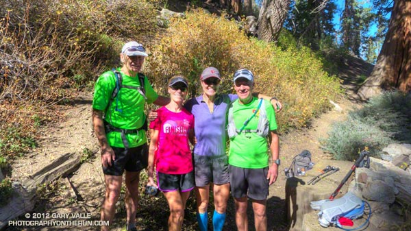
Things do seem to balance out, and as vile as the spray-painted trees were, there was an offsetting positive force in the forest that day, and we met her at Little Jimmy Spring. Leslie (Banff Trail Trash) looked like she was out for a mile or two stroll. But she had been on the trail since the beginning of August and was at about mile 2275 of the PCT! Effusive and exuberant, her enthusiasm was contagious.

For the remainder of the run we put aside thoughts about spraypaint, and just enjoyed being in the mountains.

Some related posts: Inspiration Point to Islip Saddle Trail Run, PCT from Inspiration Point to Islip Saddle

Toward Triplet Rocks

Twin Peaks and 'Triplet' ridge from the Mt. Waterman Trail

The prominent ridge extending southeast from Twin Peaks to “Triplet Rocks” can be seen from many points of the Angeles high country. So named because of the triplet of sculpted white granitic monoliths at its summit, the isolated formation is generally considered to be the hardest to reach summit in the San Gabriel Mountains.


Here’s a view of “Triplet” ridge from a run up to Pleasant View Ridge a couple of weeks ago. In the photo Triplet Rocks is the rocky peaklet on the left end of the ridge and Twin Peaks (East) is on the far right. Peak 6834 is the prominent square-topped formation a little left of the midpoint of the ridge.

Today’s loosely formulated plan was to run/hike to the summit of Twin Peaks (east) and then see how far I could get out on the ridge in a reasonable amount of time. At the start of the run I had no idea what a “reasonable amount of time” would be.


It took me about a hour and fifty minutes to reach the east summit of Twin Peaks. On the way there I realized that I should have taken a couple extra bottles of water to stash on the summit. The roughly 60 oz. of water left in my pack wasn’t going to get me very far. I figured I could go about an hour down the ridge and still have enough water to get back and have a little in reserve. The day was windy and dry, but relatively cool. If necessary I could get water at a small spring on the Twin Peaks Trail on the way back.

How far did I make it? In an hour of hiking, scrambling, bouldering, bushwhacking and challenging route-finding, I made it to a rocky ledge  below peak 7120+ and a little before the notch at peak 6834. I guessed it would have taken another 45 minutes to get to the summit of peak 6834. Next time — this wasn’t a place to push it!


I now have a much better idea of what’s going to be required to get to peak 6834 and Triplet Rocks. The north side of the ridge tends to be steep, loose, and at times very eroded. The south side of the ridge tends to be choked with scrub oaks and brush. On the way out I dropped down on the steep north slopes a couple of times; on the way back I tried some improbable lines through brush that (surprisingly) worked out and allowed me to stay more on the crest of the ridge.

It was an unusually busy day on Twin Peaks. On my way down from the peak I encountered several large groups of hikers. When I got back down to the car two tour buses were parked at the trailhead, their drivers patiently waiting for their patrons. Round trip the adventure had taken almost exactly six hours.

Notes:

In the fall of 2010 an experienced hiker doing this ridge became disoriented in rain, snow and whiteout conditions and was reported overdue. Following an air and ground search he was located on the ridge and airlifted to safety. He had notified a relative of his planned route and must have had most of what he needed to get by for the two nights and three days he was out. According to news reports he was in good enough shape to drive home following the rescue.

In April 2021 a hiker who became lost in the Mt. Waterman – Twin Peaks area was found on “Triplet” ridge after spending the night out. The hiker was located with the help of mapping enthusiast who used a photo taken by the hiker to narrow down his location.  The area where he was found was within the Bobcat Fire burn area, and was closed at the time .

Pleasant View

View from Pleasant View Ridge

This morning did a short out and back run from the Eagle’s Roost Picnic Area to peak 8248 on Pleasant View Ridge.

The title photograph is from near the summit of peak 8248. Twin Peaks East and Twin Peaks West (last Sunday’s run) are the prominent peaks on the right skyline. Kratka Ridge, Angeles Crest Highway and the Williamson Rock area is toward the camera from Twin Peaks. Eagle’s Roost is on Angeles Crest Highway near Williamson Rock.

Some related posts: Pleasant View Ridge Snow, Peaks Along Pleasant View Ridge