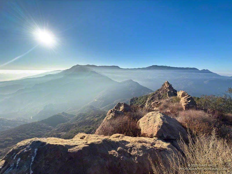
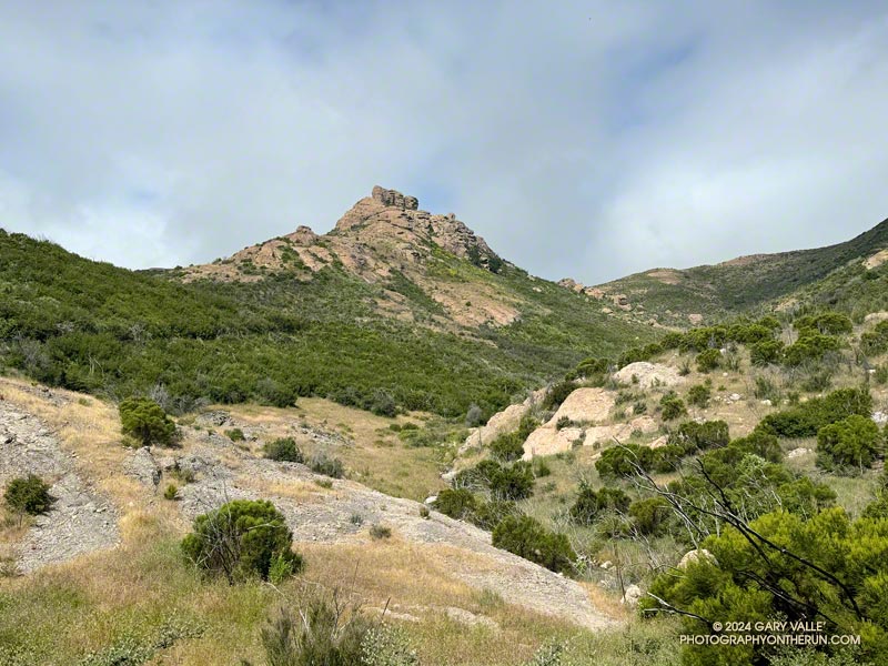
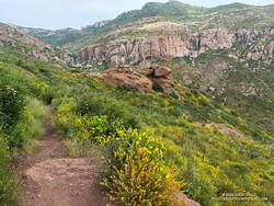
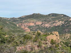
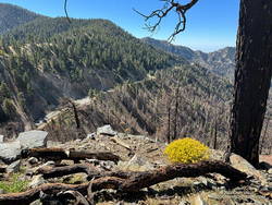
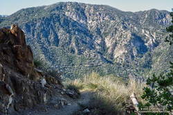
Topanga Ridge, Lookout, and Saddle Peak from Calabasas Peak’s Southeast Ridge.
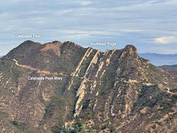
On the way down from Saddle Peak last Sunday, the “knob” at the end of Calabasas Peak’s southeast ridge caught my eye. For some time, I’ve been curious about the ridge and the unique sandstone ribs that form its backbone. The odd knob at the end of the ridge just increased my curiosity.
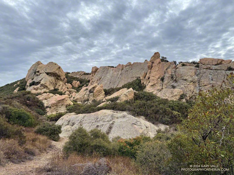
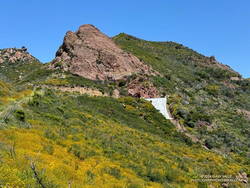
Calabasas Peak from the Stunt High Trail.
This morning found me running (and hiking) up Calabasas Peak Mtwy. fire road towards Calabasas Peak. My rough plan was to do Calabasas Peak, explore the rock formations along the peak’s southeast ridge, and then do Topanga Lookout Ridge Loop and Saddle Peak.
Near the top of the fire road, I stopped to take a photo of the rock formations and rising sun. The marine layer created a peculiar veil of fog and haze that accentuated the rocks and ridges.
After a quick ascent of Calabasas Peak, I returned to the viewpoint at the top of the fire road and started working down the southeast ridge. A steep, brushy, convoluted, little-used path wound down and around the tops of the rock ribs along the ridge to a small clearing at a saddle below the “knob.”
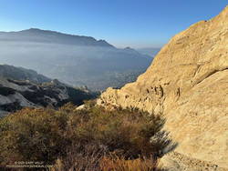
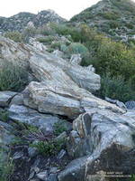
Sandstone rib on Calabasas Peak’s Southeast Ridge.
It turned out that it was not a knob but another rocky rib that looked like a knob when viewed head-on. It was relatively easy to access the rib from the clearing. I ascended the rib until I ran out of rock, then descended it to a point below where I had joined it.
Later in the run, when I was on the way down from Saddle Peak, I looked across the canyon at the “knob” on Calabasas Peak and smiled. Checking it out had been an enjoyable adventure.
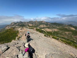
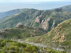
The rock formations above are near the top of Saddle Peak, in the Santa Monica Mountains, near Los Angeles. Virtually all have been climbed, and climbers will be seen on Corpse Wall (photo center) most weekends.
I took the photo while doing the Topanga Lookout Ridge Loop. I do the loop clockwise from the trailhead on Stunt Road that’s across from the start of Calabasas Peak Mtwy fire road. The bottom of Topanga Lookout Ridge is about three-quarters of a mile up the fire road.
A use trail ascends the ridge. The easiest route requires a little straightforward scrambling but bypasses the more exposed climbing on the crest of the ridge. There are four or five optional segments where the rocky crest can be followed instead of the use trail.
I enjoy doing trail runs with an added element of adventure, exploration, or quirkiness. A run might climb a peak, look for a particular wildflower, or check out a rock formation, a creek, or an old trail. The possibilities are endless.
Whenever I’ve done the out-and-back trail run from Encinal Canyon to Mishe Mokwa, I’ve thought about extending it to Sandstone Peak. Doing so would add the ascent of the highest peak in the Santa Monica Mountains to an already excellent run. Even better, I could run from Encinal Canyon to Mishe Mokwa, do the Mishe Mokwa Loop — including Sandstone Peak — then run back to Encinal Canyon. That would be an exceptionally scenic 26+ miles, with much of it on the Backbone Trail.
An advantage to doing the run this Spring is that back-to-back wet rain seasons have recharged the area’s streams, and I would (theoretically) be able to get water from a creek on the Mishe Mokwa Trail. Another plus is that all the rain has resulted in historic conditions, with extraordinary displays of a variety of wildflowers.
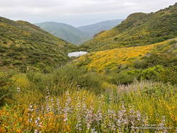
Pond along the Backbone Trail, surrounded by deerweed, black sage.
The day dawned overcast and cool, a deep marine layer covering most of the area. I was running west on the Backbone Trail between Encinal Canyon and Mishe Mokwa. The weather could not have been better for the initial 10+ miles of what I hoped to be a challenging and enjoyable run.
About 8 miles into the run, as the Backbone Trail crossed the west shoulder of Triunfo Peak, a new trail sign had been posted. It marked the recently completed trail connecting the Backbone Trail to Yellow Hill Fire Road and the top of Triunfo Peak. The new trail replaces a use trail that had evolved here, and expands the route choices when running or hiking in the area.
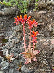
Canyon live-forever on the rocks below Mishe Mokwa.
I had planned to make a go-no-go decision at Mishe Mokwa, but something in me had already made that decision miles ago.
When I reached Mishe Mokwa, I didn’t stop. I jogged across Yerba Buena Road and started hiking up the Mishe Mokwa Trail. It was still cool and my legs felt surprisingly good. The only question was: Would the creek at Split Rock actually be running?
Having run the Mishe Mokwa – Sandstone Peak Loop on other adventures, and climbed at Echo Cliffs, I was familiar with the trails. The 6+ mile loop from the Mishe Mokwa parking area is one of the most scenic short loops in the Santa Monica Mountains and deservingly popular.
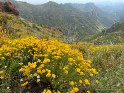
Golden yarrow along the Mishe Mokwa Trail.
The Mishe Mokwa Trail traverses the rocky slopes directly across the canyon from Echo Cliffs and Balance Rock. The dramatic rock formations are so close that climbers can be heard conversing as they climb the steep faces. This stretch of trail is demanding and has a few steep steps— up and down — that have to be navigated.
As I worked past Echo Cliffs, I passed a large group of hikers that had stopped to enjoy the view from the top of a prominent outcrop.
Earlier, I’d encountered a runner coming down the trail, and he’d been pessimistic about using the creek as a water source. But the burbling sound echoing in the canyon below me left little doubt that the creek was running.
A wildflower-lined section of the Mishe Mokwa Trail near Echo Cliffs.
It seemed everyone on the trail converged at Split Rock. When I arrived, one large group was already taking a break there, and by the time I finished getting water, another group joined them.
As a water source, the creek was a bit funky. I debated skipping it but thought of a friend’s comments regarding water sources on the Arizona Trail. How bad could it be? The drainage below Tri Peaks is relatively isolated and there are no cattle. At least, that’s how I rationalized it.
With the cool conditions, I only needed about a half-liter of water. And, of course, a little way up the trail, there was another — probably better — water source. I briefly debated dumping my water and refilling, but decided to continue.
At Split Rock, the character of the trail changes. It becomes much more straightforward as it gains elevation, passes below Tri Peaks, joins the Backbone Trail, and circles around to Sandstone Peak.
After being cloudy for most of the run, skies cleared while I was on Sandstone Peak.
Given the number of people on the Mishe Mokwa and Backbone Trails, I expected the top of Sandstone Peak to be a busy place. But the timing worked out perfectly — only two people were on the summit. Most of the clouds had cleared, revealing Sandstone Peak’s superb views.
Since I did the loop counterclockwise, the return to the Mishe Mokwa parking area from Sandstone Peak was much shorter (and steeper) than the trails to get there. Bush lupine lined the road; its unique fragrance and vibrant color a treat for the senses.
Damaged section of the Backbone Trail above Mishe Mokwa
Partway down, the shoulder of the trail had collapsed in a slide. It had been temporarily stabilized with a large white sheet of plastic that must have been visible from miles away. Continuing the descent, I took great care not to miss the turn onto the connector to the Mishe Mokwa Trail. At this point in the run, I didn’t want to do any “bonus mileage!”
The return from Mishe Mokwa to Encinal Canyon is a bit of a blur. Everyone I encountered on the trail — and particularly the mountain bikers — were super-cool, several offering a quick high-five as they passed. The encouragement must have helped — my time returning to the Encinal Canyon Trailhead was faster by a few minutes than the time going out!
And BTW, even though it was a cool day, I was nearly out of water when I got back to Encinal. It took a little time to purify the water from the creek but having the additional water helped. So far, no obvious problems have resulted.
The Triunfo Peak Access trail forks off the Backbone Trail at a prominent eucalyptus tree.
Following more wet weather, I was back on the Backbone Trail and running in the direction of Mishe Mokwa from the Encinal Canyon trailhead. But this time, instead of going to Mishe Mokwa, I planned to do an out-and-back run to Triunfo Peak (2658′).
Echo Cliffs from Yellow Hill Fire Road on Triunfo Peak. Click to enlarge.
Whenever I’ve been on the Yerba Buena segment of the Backbone Trail, I’ve been curious about this peak. Situated on the crest of the Santa Monica Mountains, east of Sandstone Peak, it seemed like it might be an outstanding viewpoint, and I wasn’t disappointed.
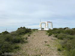
About a half-mile up the Backbone Trail from the Encinal Canyon trailhead, I was surprised to be able to get a glimpse of the peak. Historic topo maps labeled the fire lookout on Triunfo Peak as “Triunfo Lookout” and now the peak is often referred to by that name.
Rock formations near the Grotto. Click to enlarge.
Thin high clouds veiled the sun and muted the scene as I descended the Backbone Trail to Yerba Buena Road. To the west Triunfo Peak/Lookout, Boney Mountain, and Sandstone Peak filled the skyline, their rocky prominences inviting further exploration.
According to the Former Fire Lookout Sites Register and Fire Lookouts websites, the lookout on Triunfo Peak was established in the early 1930s and taken out of service in the late 1960s. A steel lookout tower originally on Blue Ridge in Angeles National Forest was first moved to Bodle Peak around 1930, then moved and reassembled on Triunfo Peak in 1935.
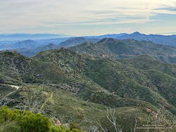
View east from Triunfo Peak along the crest of the Santa Monica Mountains. Click to enlarge.
A short connector trail is being constructed on the wet/northwest side of Trunfo Peak. When the trail is complete, it will connect the Backbone Trail to Yellow Hill Fire Road, near the summit of Triunfo Peak. The new trail will enable those doing the Backbone Trail to climb Triunfo Peak and return to the Backbone Trail without backtracking.
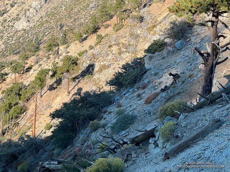
Bighorn sheep blend into the rocky terrain near Windy Gap
Had they not dislodged some rocks, I doubt I would have seen the three bighorn sheep in the photo above. They are easier to see in this zoomed-in photo of the sheep descending the rocky slopes just below Windy Gap (7,588′) in the San Gabriel Mountains. They crossed a brush-covered rib and disappeared from view.
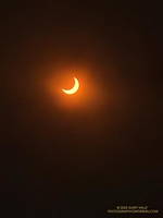
The partially-eclipsed sun crests a ridge east of Windy Gap.
A few minutes after seeing the sheep, I reached Windy Gap and stopped to put my arm sleeves away. It had been cool at the trailhead — about 40 degrees — but the temperature had warmed as I worked up the trail. As its name suggests, the wind can be fierce at Windy Gap, but this morning there was almost no wind, foretelling nearly ideal weather for today’s adventure.
Windy Gap was still in shade, and the sun was just peeking over the ridge to the east. You couldn’t tell, but the eclipse had already begun. The eclipse would be nearly total in parts of Oregon, Nevada, Utah, New Mexico, and Texas. In the Los Angeles area, the moon would obscure more than 70% of the sun’s disc.
Partially eclipsed sun.
From Windy Gap, I headed east on the Pacific Crest Trail toward Mt. Hawkins. From time to time, I would stop and check the progress of the eclipse using eclipse sunglasses. In sunny areas, I looked for lensed images of the sun in the shadows of trees but didn’t see any. Having needles instead of leaves, conifers don’t produce the myriad images of the eclipsed sun seen under trees with leaves.
With nearly three-quarters of the sun obscured, the light from the sun had become enfeebled. The feeling was more than that of a cloud passing in front of the sun. I stopped and listened… to nothing. It was eerily quiet. No birds called or sang, and only chill zephyrs of wind wafted about the area. Somehow, the sun was broken.
The south ridge of Mt. Lewis can be accessed from the CalTrans shed at Dawson Saddle.
As the eclipse slowly waned, I continued east in the corrupt light, past Mt. Hawkins and Throop Peak, to the PCT’s junction with the Dawson Saddle Trail. In what seemed fitting for the day, instead of continuing to Baden-Powell, I turned left and headed down the trail toward Angeles Crest Highway (Highway 2).
Why? Angeles Crest Highway was closed from Red Box to Vincent Gap, transforming Dawson Saddle into one of the more isolated areas of the Angeles National Forest. I hadn’t been on the Dawson Saddle Trail in years, and with Highway 2 closed, it would be a quirky way to climb Mt. Lewis. Instead of having one of the shortest approaches in the San Gabriels — a few feet from the CalTrans shed at Dawson Saddle — it would involve a trail run of nearly eight miles just to get to the base of the peak.
Angeles Crest Highway from the shoulder of Mt. Lewis.
The eclipse was nearly over when I reached the bottom of the Dawson Saddle Trail on Highway 2. From the trailhead, I ran up an empty Angeles Crest Highway a short distance to Dawson Saddle. Mt. Lewis’ south ridge was accessed from here.
Only about a half-mile long, the south ridge isn’t technical, but the first third is steep and rocky. The elevation gain from the saddle to the summit is about 500′. Offset from the crest of the San Gabriels, the flat summit of Mt. Lewis has unique views of the crest extending from Mt. Baden-Powell to Mt. Islip and beyond.
After a few minutes enjoying the summit, I turned southward and began working my way back down to Angeles Crest Highway, up to the PCT, over to Windy Gap, and back down to the trailhead in the Crystal Lake Recreational Area.
The northwest ridge of Strawberry Peak just before the Class 2-3 rock climbing segment.
Usually, I prefer to start the Strawberry Peak Summit Loop at the Colby Canyon Trailhead on Angeles Crest Highway. But it had been a while since I’d done the loop from Clear Creek, and I was feeling a little nostalgic. One of the aid stations for the ANFTR/Mt. Disappointment race is at Clear Creek, and the course climbs Josephine Fire Road.
I was also curious how my time to Josephine Saddle using the fire road would compare to the direct route up the Colby Canyon Trail. As it turned out, at a moderate pace it was about the same either way.
Foliated rock along the use trail to the northwest ridge of Strawberry Peak
The use trail up from Josephine Saddle was in decent condition. It looked like it may have recently had a snip here and there. Part way up the path, an outcrop on the ridgeline provides a good warmup for the climbing higher up. The circuitous path eventually ends at the base of the steep, jumbled northwest ridge of Strawberry Peak. I was surprised to find two small patches of snow here.
It’s difficult to describe the route on the ridge since there are many variations. It’s not fear-mongering to say that people get into trouble on this section. A common comment about this segment is, “Don’t climb anything sketchy or difficult.” But what is an easy scramble for one person may be nearly impossible for another. With 50+ years of rock climbing experience, I still remind myself not to climb up anything I’m not 100% sure I can climb down. If you don’t have “real” rock climbing experience, go with someone that knows the route.
Small patches of snow on the NW side of Strawberry Peak on April 30, 2023.
Following a wet, snowy, cold Winter, I took extra care while climbing. Solid holds and blocks can sometimes be loosened over the Winter and fail unexpectedly. This morning, I didn’t notice any obvious changes on the route I climbed.
The setting changes dramatically on the east side of Strawberry Peak. You go from the cool shadows of a steep, rocky face with (typically) no one around to a sunny, sandy, busy summit and trail.
As I approached the summit, a couple of people were setting up to do a video for a vlog. Another person had just reached the top, and another hiker wasn’t far behind. With snow in the high country, Hwy 2 still closed at Red Box, and the Bobcat Fire Closure still in effect, the trail up Strawberry was a popular option. The question of the day from the people coming up was, “How many false summits are there?”
Looking across the canyon to the Gabrielino Trail below Red Box, and Supercloud Canyon
Overall, the Strawberry Peak Trail was in reasonable shape. The trail needed a little work in a few places, but as far as mountain trails go, its condition was about what you would expect. In several places, the trail was carpeted with the remnants of old yucca leaves. Very nice!
Just before reaching Red Box, I snapped a photo of the snow on Mt. Baldy. At Red Box, all but one parking space was taken, and that one was snagged by an arriving car.
As I started down the Gabrielino Trail from Red Box, LASD Air Rescue 5 began to orbit overhead. Apparently, there had been yet another vehicle accident on Angeles Crest Highway. It wasn’t long until I heard the whaling sound of sirens coming up the canyon.
Upper Arroyo Seco at Switzer’s Picnic Area.
Some trailwork had been done on the upper half of Gabrielino Trail between Red Box and Switzer’s. Quite a few small trees and limbs had been removed from the trail, and the bushes trimmed. Most of the work (as of today) ended at mass of fallen trees halfway down the trail.
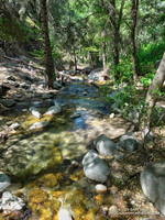
Upper Arroyo Seco was flowing. The sound of water plunging over the debris dams made the flow seem higher than it was. There were a couple of minor creek crossings.
Switzer’s was busy — as usual. To finish the loop, I walked up the stairs to the access road and hiked up to the start of Nature’s Canteen Trail. It was a bit overgrown, but I was back at Clear Creek in a few minutes.