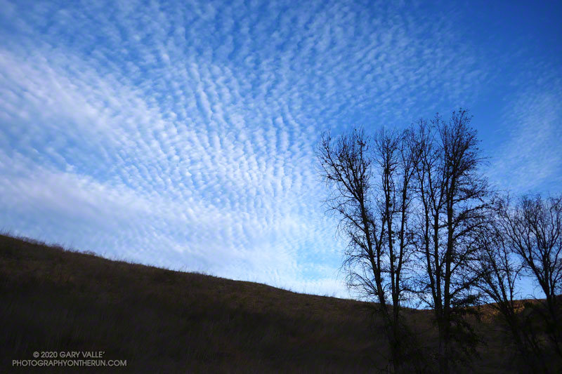
Cirrocumulus clouds form at high altitude. They are primarily composed of ice crystals but also contain supercooled water droplets.
The photograph of cirrocumulus clouds was taken in Las Virgenes Canyon on a trail run from the Victory Trailhead of Upper Las Virgenes Canyon Open Space Preserve, also known as Ahmanson Ranch.
Except for a teaser storm system in early November that brought a smattering of rain to the metro area and some snow to the mountains, the Los Angeles rain year is off to a parched start.
As of December 1, Downtown Los Angeles (USC) has recorded only 0.11 inch of rain since July 1. Along with 1995, this is the 7th driest start to the rain year over the 144 years weather records have been kept in L.A.
Update December 29, 2020. In the first significant storm of the rain year, Downtown Los Angeles recorded 1.82 inch of rain, bringing the rainfall total up to 1.95 inches. The storm total was more than generally forecast, but L.A. is still about 2 inches below normal for the date. The rain does move 2020 out of contention for the driest first six months of the rain year.
Update December 20, 2020. The period July 1 – December 20, 2020 is the driest on record (for that date range) for Los Angeles. As of December 20, the rainfall total for Downtown Los Angeles (USC) remains at 0.11 inch.
While “past performance may not be indicative of future results,” I was curious to see if, historically, a dry start to the rain year has generally resulted in below average annual rainfall.
There have been 16 years in which Los Angeles precipitation was 0.25 inch or less for the period July 1 to December 1. Rain year precipitation (July 1 – June 30) for those years varied from a low of 4.79 inches in 2017, to a high of 23.43 inches in 1937. Overall, these years averaged 11.34 inches of rain annually, which is 3.66 inches below the current normal of 14.93 inches.
Whether or not annual rainfall this rain year is below normal we’ll have to see. An important consideration is that La Nina conditions are present in the equatorial Pacific. This doesn’t necessarily mean less rainfall in the Los Angeles area, but taking into account a number of factors, the Climate Prediction Center is projecting below average precipitation this Winter in Southern California.
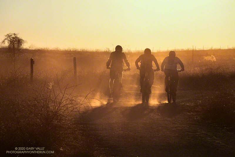
The title photo of silhouetted mountain bikers is from this afternoon’s run at Upper Las Virgenes Canyon Open Space Preserve (Ahmanson Ranch). The image is an example of a “silhouette illusion.” Are the riders going toward or away from the camera?
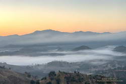
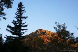
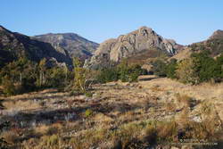
Above are thumbnails of a few photos from a 20-mile out and back trail run to Mugu Peak from the Wendy Drive Trailhead. The run was on October 17, 2020. Click on an image for a larger photo and more information.
There are several ways to get to Mugu Peak from the Wendy Drive Trailhead on Potrero Road. When I do this run I’m usually looking to do a longer, faster-paced run without a huge amount of elevation gain. That translates to running down Big Sycamore Canyon to Wood Ranch Road and then either running up the Backbone Trail or Hell Hill to the “hub,” and from there to La Jolla Valley and Mugu Peak.
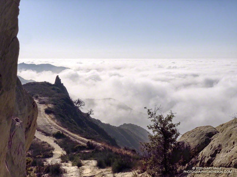
Marine layer clouds from the Backbone Trail at “Mammoth Pass.”
The Bulldog Loop, without any extras, is a little over 14 miles long, with an elevation gain of about 2700′.
While doing the Phantom Loop last week, I was reminded that a good way to extend the Bulldog Loop is to combine it with the Phantom Loop. This produces a run of about 19 miles, with an elevation gain of around 3650′.
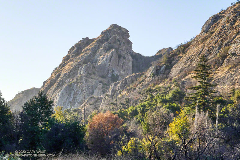
Early morning view of Saddle Peak from the Cistern Trail
This weekend I was looking to do something a little longer. With the National Forests in Southern California still closed, the usual high country options weren’t available. The temperature forecast looked warm, but not crazy hot, so it was a good day to do this run.
The Cistern/Phantom Trailhead on Mulholland Highway is a convenient place to start and end the loop. Later in the run, water is usually available from a faucet and fountains adjacent to the restrooms at the main MCSP parking lot. If doing the loop counterclockwise from the Cistern Trailhead, the restrooms and water are about 14 miles into the run.
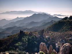
Santa Monica Mountains from the top of the Bulldog climb.
The main attraction is still the Bulldog climb. From Crags Road to Castro Mtwy, the Bulldog Mtwy gains about 1730′ over about 3.4 miles. From the MCSP parking lot to the high point on the Phantom Trail, the route gains a bit more than 1000′ over 4.7 miles.
A coast redwood stands above the other trees near Century Lake.
It was a chilly 45°F as I crossed algae-covered Malibu Creek on a foot-worn log. Following a brutally hot Summer with temps in the West San Fernando Valley reaching 121°F, the chill of the cold air felt especially good.
The plan was to do the Phantom Loop, but first, I was going to run over to the Forest Trail. The side trip was not only to check on the coast redwoods along the trail but to enjoy the calm beauty of the area. To say 2020 has been unsettling is like saying a rattlesnake bite is a little annoying — and the year isn’t over yet.
Coast redwood near the Forest Trail and Crags Road junction
Continuing along the Forest Trail toward Century Lake, I counted four healthy-appearing redwoods and two struggling trees. Redwoods sometimes grow in a group of two or more trees, and these were counted as a single “tree.” Near the end of the trail is a naturally-germinated redwood that has grown to about 5.5 inches in diameter. Remarkably, this young tree survived the 2011-2015 drought and the 2018 Woolsey Fire, and appears healthy!
I had just finished photographing the young tree when a Cooper’s or Sharp-shinned Hawk flew from a nearby oak and through the trees along the trail. It landed on the limb of an oak ahead of me but was in deep shade. In a much-enlarged image, the bird looks like a Sharp-shinned Hawk, but distinguishing the two species can be challenging.
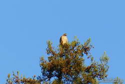
Red-tailed hawk atop a coast redwood.
A few yards down the trail, a much larger raptor — a Red-tailed hawk — was perched at the top of the tallest redwood. The huge bird had its wings pulled back to expose more of its body to the warming sun. It looked like a giant penguin sitting atop a tree. As I approached, it began to preen its feathers, comfortable with its lofty position.
With a sigh, I left the Forest Trail behind and returned to Malibu Creek. This time I crossed the creek on a plank near the washed-out bridge. This was a more direct route than the fallen tree upstream but only worked because the creek was low. At the crossing, a passing runner asked if he was on the Bulldog Loop. I assured him he was and was a little envious that he was getting to experience that excellent run for the first time.
Morning view of Goat Butte and stream course of Malibu Creek
As usual, Crags Road and the High Road were busy thoroughfares. The easy running under the sprawling coast live oaks was pleasant, and the morning view of Malibu Creek and Goat Buttes outstanding.
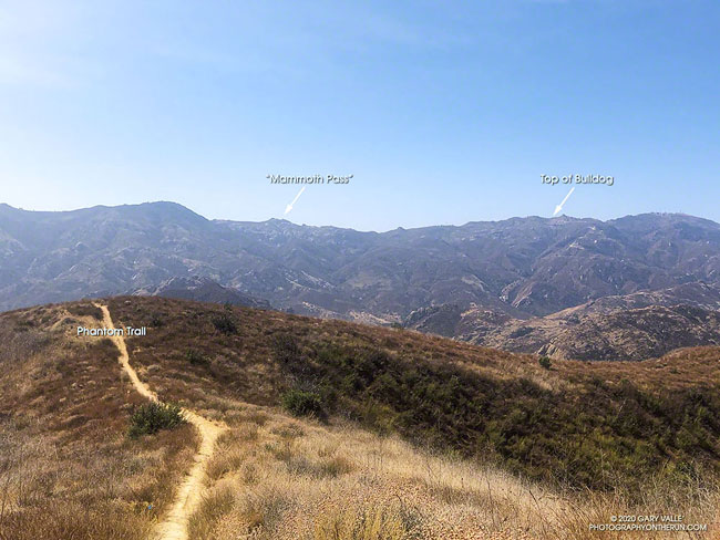
In a few minutes, I’d reached Mulholland Highway and then followed the Grasslands Trail to the Liberty Canyon Trail. From Liberty Canyon, the Phantom Trail gains about 750′ in elevation over about 1.5 miles to a high point and ridgeline with excellent views of Saddleback Peak, Las Virgenes Canyon, Brents Mountain, Goat Buttes, Castro Peak, Ladyface, and Boney Mountain.
The air quality this morning hadn’t been too bad. From up on the ridge, I could see there was far less smoke to the west of Las Virgenes Canyon than to the east. Yesterday, I’d done a run in the eastern Santa Monica Mountains and had to cut the run short because of smoke. That wasn’t a problem today, and the run had been a good one.
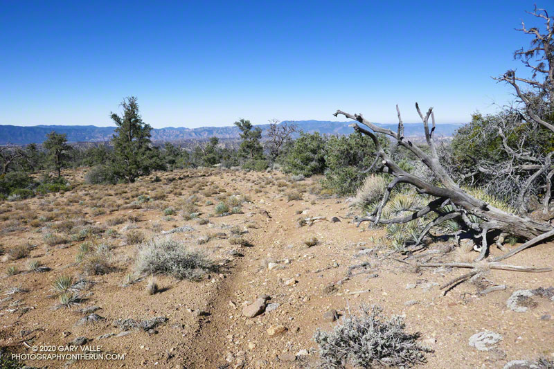
Mesa Spring Trail near the top of San Emigdio Mesa.
For many that enjoy the outdoors, there is an insatiable desire to go where we have not been, learn what we do not know, and discover what we have not experienced.
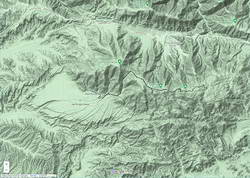
Each time I’ve done the out and back trail run from Mt. Pinos to Mt. Abel, I’ve been curious about the Mesa Spring Trail. The trail leaves the Tumamait Trail at Puerto del Suelo, a saddle about 0.6 mile east of Mt. Abel Road, and descends to a campsite at a spring on the margin of San Emigdio Mesa. The mesa is the large alluvial fan shown on this Google Terrain Map overview.
The Mesa Spring Trail is part of an old trail shown on the USGS 1903 Mt. Pinos topo map. The old trail was part of a route that connected the Cuyama River to the historic El Camino Viejo a Los Ángeles. It followed Dry Canyon, went over Puerto del Suelo, and to the valley that is now the Pine Mountain Club. Like so many trails, it must have evolved from a hunting and trade route.
Google Terrain map showing San Emigdio Mesa and my route from Mt. Pinos
The Mesa Spring Trail is usually accessed from the West Tumamait Trailhead on Mt. Abel Road. But it occurred to me that starting at the East Tumamait Trailhead on Mt. Pinos might be an enjoyable way to do a longer out and back run. The Mesa Spring Trail looked like it might be similar to the North Fork Trail — a little less used and a bit more remote.
I left the Chula Vista parking area a little before 7:00 a.m. and started chugging up the road to the East Tumamait Trailhead at the Mt. Pinos Condor Observation Site. I planned to skip the usual side trips to Sawmill and Grouse. The spring was at a much lower elevation, and I wanted to get there before the temperature sizzled.
Once on the Vincent Tumamait Trail, it took a little over an hour to reach the top of the Mesa Spring Trail. The junction is marked with a new sign and tree branches on the ground. It is about 5.7 miles from the Mt. Pinos parking area.
Plant communities change dramatically with elevation. This Jeffrey pine forest is at about 7000′.
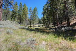
The first couple of miles down from the junction, the trail more or less follows the drainage. About 10 minutes from the junction, a large pine tree had fallen and completely blocked the trail. I worked around the right (west) side of the tree, where some orange fence posts had been placed. A few minutes beyond the collapsed tree, the trail wandered around the right side of a pretty meadow and then back to the “V” of the dry stream.
For the next mile or so, the trail followed a typical down-canyon route. On the way down, there were some spots where I stopped, turned around, and made a mental note of what the trail did. It wasn’t so much a matter of getting lost, as it was not wasting time at an ambiguous spot on the way back.
About 2.3 miles down from the saddle, the trail climbed out of the canyon, taking a counterintuitive turn to the right. After reaching a ridgeline, the trail turned back left and continued downhill. But its wanderings were not over. The trail was working across the gullies at the top of the San Emigdio Mesa. It went up, down, and around, but eventually did go to Mesa Spring. There were “ducks” marking the route, but it really helped to have looked at a map and have a general idea of where the trail would go.
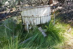
Mesa Spring is on the northern margin of San Emigdio Mesa.
Mesa Spring is a pretty green spot in a group of pinyon pines. As I neared the spring, I saw some coyote-like ears bobbing through the sagebrush, and not long after that, a deer bounded through the trees. At the spring, a squirrel leaped from the edge of the water-filled cistern to a nearby tree and various birds flittered in the pines. I heard a trickle of water near the cistern’s base but planned to get water at Sheep Camp, later in the run.
With its bounty of pinyon pine nuts, acorns, juniper berries, game, and more, San Emigdio Mesa provided vital resources for the local Chumash.
Although the Mesa Spring Trail continues down the mesa, the spring was my turnaround point. I had waited for a day when the weather was better for this run. A weak low-pressure trough moving through to the north had stirred up a little wind and taken the edge off the recent heatwave. It had been cool on the crest, but at 6000′ it was already hot in the sun. It was time to get moving, and in a few minutes, I was retracing my steps and headed back to Mt. Pinos.

 Above are thumbnails of a few photos from a 20-mile out and back trail run to Mugu Peak from the Wendy Drive Trailhead. The run was on October 17, 2020. Click on an image for a larger photo and more information.