Category Archives: landscape

Guardian Oaks

Young valley oaks and coast live oaks at the edge of the canopy of large valley oak in Upper Las Virgenes Canyon Open Space Preserve.

One day while running at Ahmanson Ranch, I was admiring the stately limbs of a large valley oak, and noticed that along the margin of the canopy were several sapling oaks. As I continued my run, I found that only a few other valley oaks hosted a brood of young trees.

That oaks would sprout on the margin of the canopy made sense. There is an abundance of acorns at the ends of the limbs. It is also where water drips from the oak’s leaves on foggy days or when there is light rain or drizzle. The mix of sun and shade on the edge of the canopy is the perfect place for a young oak to thrive.

The surprise came when I took a closer look at the young trees. Most were valley oaks — the same as the shepherding tree — but in some cases the young trees were coast live oaks! And sometimes there was no obvious parent coast live oak nearby.

Of course, there are plenty of coast live oaks at Ahmanson and several ways for their acorns to find their way under a valley oak. Birds and squirrels love to stash acorns, and gravity is good at moving round things downhill.

Time is at a different scale for a tree. In my mind’s eye I accelerated time and watched as the young oaks surrounding a guardian oak grew in stature. Fire sweeps through the frame on several occasions. During one fire the old brood tree collapses and in another fire, the collapsed tree disappears from the frame. Of the young oaks that have survived, one dominates, spreading its limbs and growing large and robust. Along the margins of its canopy, I can see several sapling oaks…

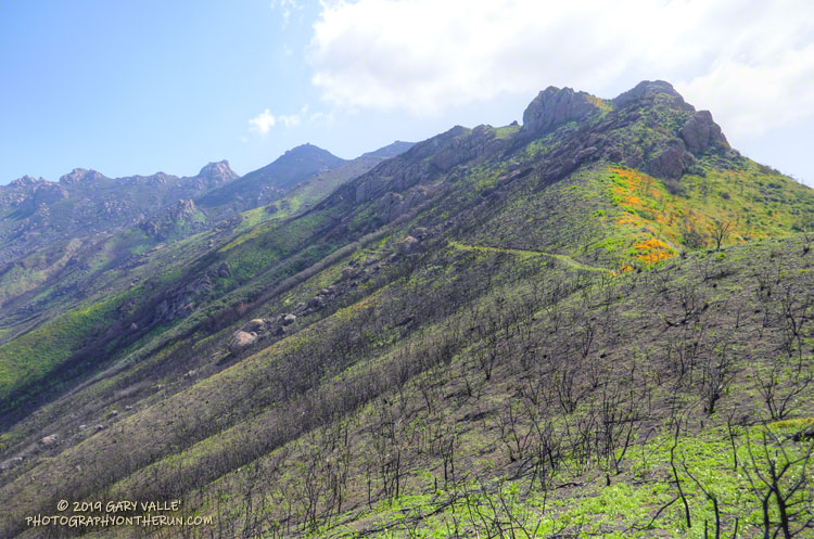
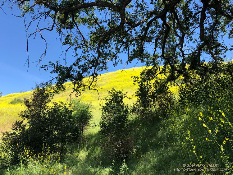
Note: The young oaks in the title photo are an older brood that survived the Woolsey Fire, but many younger sapling oaks were killed. Introduced grasses, black mustard, and other introduced plants produce higher fuel loads than native equivalents and increase fire mortality.

Two Sides of Strawberry Peak

Strawberry Peak's Northwest Ridge
Northwest ridge of Strawberry Peak.

Update March 28, 2021. The use trail between Josephine Saddle and the rock climbing segment of the northwest ridge is in somewhat better condition this Spring.

Where did the trail go? Rejuvenated by substantial Winter rains, the whitethorn on Strawberry Peak was not only impinging on the trail, but also my arms. I took my running sleeves out of a pocket of my pack and pulled them on. That helped, and I was able to push through some thorny limbs to the next clear section of the path.

Chaparral whitethorn blocking the use trail along Strawberry Peak's northwest ridge.
Chaparral whitethorn blocking the use trail along Strawberry Peak’s northwest ridge. Click for larger image.

When following an overgrown trail I’ve learned to trust the “sense” of the trail. Even if it doesn’t look like there is a route forward, if you just take a few steps a seemingly impassible trail often becomes passable. I sometimes look at the trail behind me to confirm I’ve really been following a trail, and am continuing its path. If it doesn’t open up, I backtrack to see where I went wrong.

Winding through the thick brush along Strawberry Peak’s northwest ridge, I was happy to see that all of the Poodle-dog bush along the route had finally withered and died. Poodle-dog bush is fire-follower that causes dermatitis in many people. It became very widespread in the San Gabriel Mountains following the 2009 Station Fire. Reported reactions varied from a very mild rash to a severe rash with blistering. The troublesome plant must serve some role in the fire recovery process, but I’m glad its cycle is near its end.

It seemed like it was going to be a quiet day on Strawberry. The loop I was doing began at the Colby Canyon trailhead and I’d been the first to park there. The few tracks on the trail were old and the only people I’d seen were a group of mountain bikers at Josephine Saddle. The view from the mountain was spectacular. A sea of low clouds lapped at the mountain slopes and washed into the canyons, bringing with it a feeling of wanderlust and vitality.

Colby Canyon from near the top of Strawberry Peak's northwest ridge.
Colby Canyon from near the top of Strawberry Peak’s northwest ridge. Click for larger image.

Finally reaching the steeper part of Strawberry’s fragmented northwest ridge I climbed up the initial sandy ledges to an area of somewhat better rock, taking care not to slip on the ball-bearing grains of decomposing granite. Generally, the rock improves somewhat with height. Higher on the ridge, I enjoyed doing a couple of optional boulder moves that were a little more technical. (I’d done these before and knew they were not a dead-end.)

Reaching the top of the ridge, I could hear conversation and laughter above me. From the summit ridge I could see there were people on and near the summit. I threaded my way to the summit, greeting the hikers along the way. On the summit, a small dog said hi, and I treated my new friend to an obligatory neck scratch.

In nearly five decades of doing the peak, I’d never seen so many people on the peak. I had forgotten that Angeles Crest Highway was closed at Red Box due to a rock slide. With snow in the high country and the great Spring weather, Strawberry Peak was a very popular place.

Running down to Red Box I’d encountered many more hikers, some smiling, some not, but most were enjoying being on the trail. That’s the thing about the outdoors, it just feels good to be out there.

Related post: Strawberry Peak, Switzer’s and the Old Colby Trail

Weekday Wildflowers

Goldfields along a trail in Upper Las VIrgenes Canyon Open Space Preserve

Many of my weekday runs are on the trails of Upper Las Virgenes Canyon Open Space Preserve (formerly Ahmanson Ranch).

In the wake of the Woolsey Fire and our wet rain year, the hills of Upper Las Virgenes Canyon Open Space Preserve have been covered with a dense carpet of green that has recently transitioned into a sea of mustard yellow. The grasses have now gone to seed and the hills will soon turn a summery-blond.

At first glance, just about all you see at Ahmanson Ranch is the green and yellow. But if you look closer, intermixed with the black mustard and other introduced plants are a variety of wildflowers.

In a few areas of the Preserve, there are large patches of native wildflowers, but it is more common for the native flowers to have to battle introduced plants for growing space. Some species are more successful than others.

Here is a slideshow of the wildflowers I’ve been seeing on my weekday runs, along with some comments and the date the photo was taken. Some of my weekday runs extend into Cheeseboro Canyon, so wildflowers from that area are also included. Additional photos may be added as the season progresses.

The yellow flowers along the trail on which Lynn is running are goldfields. As of April 10, there were still patches of goldfields blooming in the Lasky Mesa area.

Wildflowers, a Waterfall, and Recovering from the Woolsey Fire

The Chamberlain segment of the Backbone Trail in Pt. Mugu State Park.

The sun had not yet risen and the poppies along Danielson Road were still tightly furled against the morning’s chill. The purl of Upper Sycamore Creek resonated in the canyon below — a wonderful tone that in recent years has too often been squelched by drought.

I was running to the Old Boney Trail and the start of the ridge that follows along Boney Mountain’s western escarpment to the massif’s huge summit plateau. Several of the Santa Monica Mountains highest peaks are on this plateau, including the range’s highest peak, Sandstone Peak.

In December I’d climbed this route to check the impact of the Woolsey Fire on the area. From the top of the ridge I’d been disheartened by what I saw. Tri Peaks and Sandstone Peak and much of the top of the Boney Mountain massif were a blackened, barren mess.

Now, three months later, I was headed back to Boney Mountain and would continue to Sandstone Peak for the first time since the fire.

Here are a few photos taken along the way.

Related post: After the Woolsey Fire: Boney Mountain and Pt. Mugu State Park

After the Woolsey Fire: Malibu Creek State Park March 2019

Malibu Creek State Park following the Woolsey Fire and heavy Winter rains.

Parked in a turnout on Mulholland Hwy, I finished putting on sunscreen and then pushed the Start/Stop button on my watch to dial in the GPS and pair my HRM. Outside, it was a chilly 43 degrees. Sunrise was nearing and the strengthening March sun was forecast to push temps well into the 70s.

In the aftermath of Woolsey Fire, I’d returned to Malibu Creek State Park to see the wildflowers; gauge the response of the creek to heavy Winter rains; check on the health of the redwoods along the Forest Trail, and assess the ongoing recovery of the burned chaparral.

Today’s run of the Bulldog Loop would be a follow-up to two runs in the park in December 2018, which found a fire-ravaged landscape just beginning the long process of recovery.

Here are a few photos taken along the way.

Some related posts: After the Woolsey Fire: Bulldog Loop, After the Woolsey Fire: Malibu Creek State Park Redwoods, M*A*S*H Site and Bulldog Climb

Running to Ray Miller

Mountain bikers enjoying the view of Boney Mountain from Overlook Fire Road in Pt. Mugu State Park.

The Ray Miller Trailhead in Pt. Mugu State Park marks the western end of the Backbone Trail, a 68-mile scenic trail along the spine of the Santa Monica Mountains. The Ray Miller Trail’s long, winding descent into La Jolla Canyon is a favorite of runners and hikers, and a fitting end to those traversing the BBT from east to west.

My run this morning was to the Ray Miller Trailhead (and back) from Satwiwa, starting at the Wendy Drive trailhead in Newbury Park. The Wendy Drive Trailhead is very popular and is the starting point for many good runs, hikes and rides. To get an idea of the route options, see the detailed trail maps on the Pt. Mugu State Park page of VenturaCountryTrails.org.

Today I was looking to do a longer run, so didn’t take the usual route. On the way down Big Sycamore Canyon, I skipped the turns at Wood Canyon (Hell Hill), Wood Canyon Vista Trail (BBT) and Fireline Trail and at Overlook Fire Road, some eight miles into the run, finally headed uphill.

View of the Pacific, Anacapa Island and Santa Cruz Island from the Ray Miller Trail
View of the Pacific, Anacapa Island and Santa Cruz Island from the Ray Miller Trail.

The top of the Ray Miller Trail is a stout 2.5 -mile climb from the bottom of Overlook Fire Road. Along the way there were excellent views of Sycamore Canyon, Serrano Valley and Boney Mountain.

About a half-mile down the Ray Miller Trail there is a popular overlook of the coast. The day was clear and there were stunning views of the Pacific and the Channel Islands. Brushed by whispers of wind, the cerulean blue Pacific filled my view for much of the descent to the parking lot.

It was an odd feeling to run down to the parking lot with runners who were cheerfully finishing their morning run, knowing that I had many more miles to go. After a quick stop at the water spigot, I turned, and sighed, and took the first steps back up the hill and toward Satwiwa.

Here are a few photos taken along the way.

Related post: Ray Miller Training Run