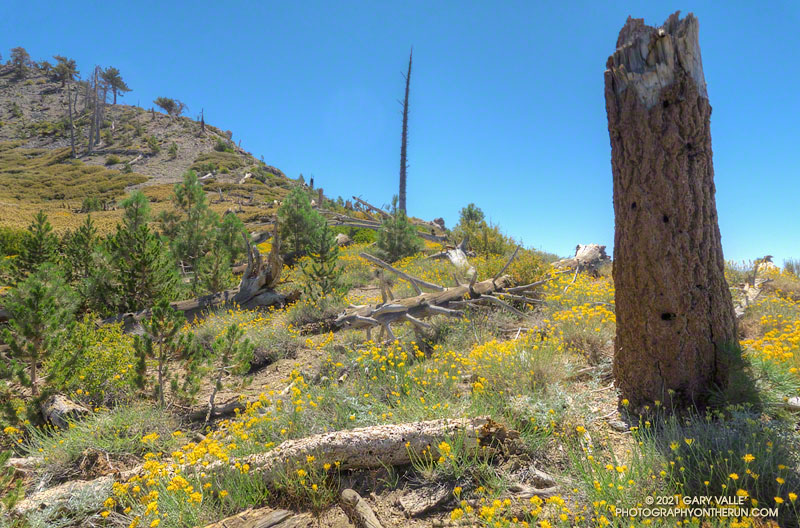
From mid Summer into Fall, the vibrant yellow flowers of rabbitbrush add a refreshing hit of color to the greens, grays, and browns of the San Gabriel Mountains.
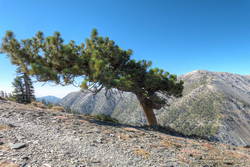
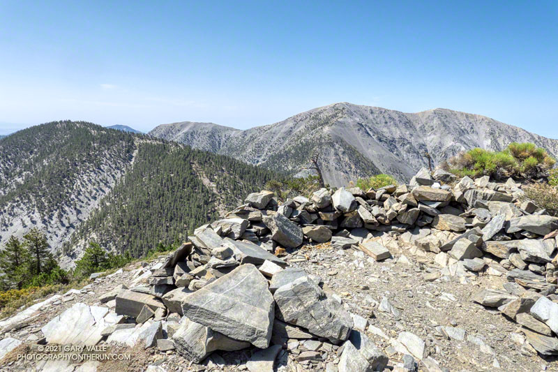
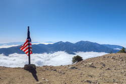
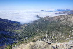
The title photo was taken along the PCT, at an elevation of about 8600′, near Mt. Hawkins. The area was burned in the 2002 Curve Fire. Here, and elsewhere in the burn area, new trees — now in their teens — are slowly replacing some of the trees lost in the fire.
The last time I was on this part of the North Backbone Trail it was bitterly cold and very windy. Today it was just very windy. Even though the air temperature was in the 70s, the “wind chill” was enough that I was considering grabbing the sleeves and shell from my pack.
I stopped in the lee of a sprawling, stunted lodgepole pine and enjoyed a moment of relief, shielded from the wind. But there wasn’t that much mountain above me, and I resumed zig-zagging up the final steep stretch of trail. Climbing a little higher, I could see the trail sign that marks the top of the North Backbone Trail.
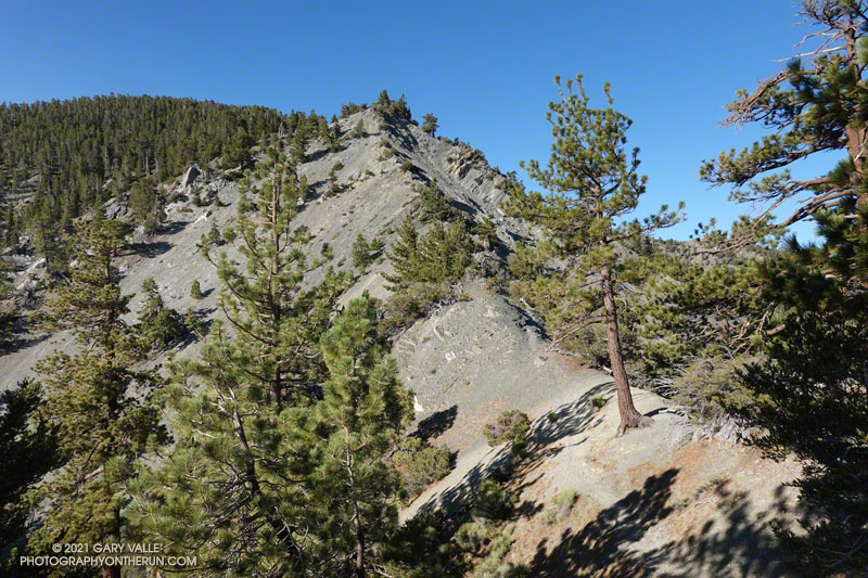
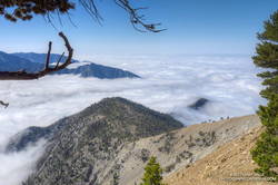
Point 8555 and Pine Mountain from the PCT
Mt. Baldy from Wrightwood is a more difficult variation of the North Backbone Trail route. Instead of driving to the North Backbone Trailhead on East Blue Ridge Road (F.R. 3N06), you run/hike to the trailhead using the Acorn Trail and a short stretch of Blue Ridge Road or the PCT. (The dirt road is slightly shorter, but you don’t have to dodge off-road vehicles when on the PCT.)
Including Pine Mountain (9648′) and a short detour to the top of Dawson Peak (9575′), the regular North Backbone route is about 8 miles long and gains/loses around 4700′. Starting in Wrightwood at the small parking area on Acorn Drive ups those totals to around 15 miles, with a 6800′ gain/loss.
Rabbitbrush along the North Backbone Trail, between Pine Mountain and Dawson Peak
A mix of hikers and trail runners were scattered across the broad summit of Mt. Baldy (10,064′). The wind wasn’t as strong on the summit as it had been on the North Backbone. Smoke from the Western wildfires reduced the visibility, but the air quality and view were still pretty good.
Like many mountains, the adventure didn’t end on the top of the peak. The elevation gain on the way back to Wrightwood is significant, and much of the downhill demands close attention — especially on tired legs. I squeezed the water bladder in my pack and tried to estimate how much was left. The day was just going to get warmer, and I hoped it was enough to get me back over Dawson Peak and Pine Mountain. On the way up, I’d stashed a small water bottle near the North Backbone Trailhead, and that would help on the final few miles.
Windswept Jeffrey pine near Dawson Peak
Other than initially running past my water stash, the descent went well. Once on the PCT I could run normally — well, more or less normally — and it didn’t take long to get over to the Acorn Trail.
When doing the AC100 and related training runs, I’d run/hiked up the Acorn Trail a number of times, but I’d never run down it. After all the rough trail on the North Backbone, it was great to be able to cruise down through a forest of pine and fir on a well-groomed trail! Here’s an elevation profile of the route.
I’d decided to stay off the higher peaks because a combination of monsoon moisture and an upper level low was probably going to produce some thunderstorms in the high country. The action was forecast to stay east of of the Mt. Wilson area, but there was a chance there might be enough clouds to knock the temperature down a few degrees.
But a chance is just that, and the day dawned mostly clear and warm at Red Box. A few feathery high clouds had no effect on the sun, and as I jogged up Mt. Wilson road to the start of the Mt. Disappointment Trail, the temperature was already in the 80s.
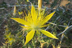
Blazing star near the Mt. Disappointment Trailhead.
I was doing a 15-mile version of the Red Box – Bear Canyon loop. The main trails that make up this version of the loop are the Mt. Disappointment Trail, San Gabriel Peak Trail, Mt. Lowe Fire Road, Upper Bear Canyon Trail, Bear Canyon Trail, and the Gabrielino Trail. Refer to a trail map for additional details.
As it turned out, the Bear Canyon Trail was in the best condition I’ve seen in years. Thank you Bear Canyon Trail Crew! While still rustic, the trail between the old cabin site and the trail camp was a bit more worn than usual, and a little easier to follow. In some years it can be much more difficult to navigate.
No one was camped at Bear Canyon Trail Camp. The condition of the creek was similar to 2018. There were a few small pools here and there, but almost no surface flow. In addition, strict fire restrictions are currently in effect. See Forest Order No. 05-01-21-04.
The dry conditions had one benefit — I didn’t have any issues with stinging nettle. There was still plenty of poison oak, but it was drying out and turning red. For the most part the poison oak could be avoided.
The Gabrielino Trail between Switzer Falls and Switzer’s Picnic area was as busy as usual, including one hiker walking their cat!
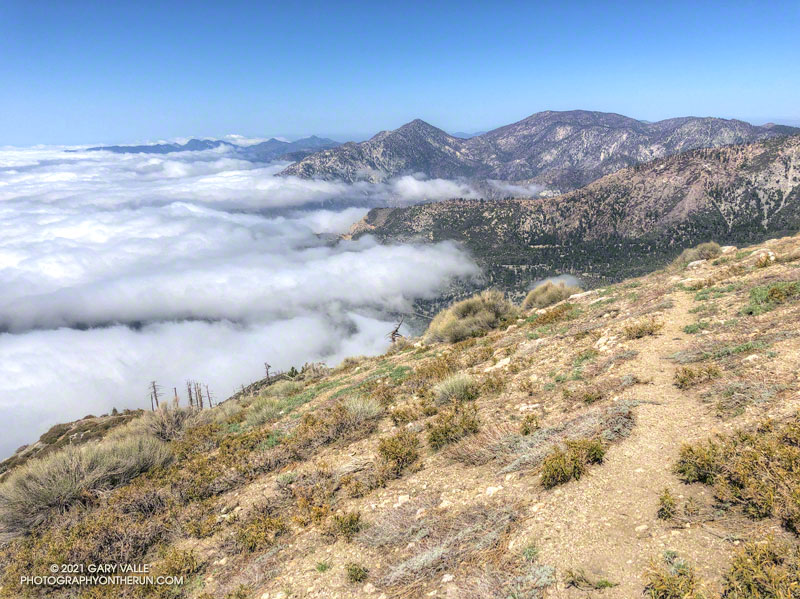
View down Arroyo Seco from the Gabrielino Trail, about 1.5 miles from Red Box
As I worked up the Gabrielino Trail above Switzer’s, I kept looking for those monsoon clouds. Temps in the sun on the exposed trail was in the high 90s, and it was a relief to finally get to the more shaded sections near Red Box.
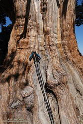
The adventure combines a seven-mile run on the PCT along Blue Ridge with a strenuous 1.5 mile, 1500′ climb up the North Backbone Trail to the summit of Pine Mountain (9648′). The Pine Mountain Juniper, estimated to be 800-1000 years old, is found at the 9000′ level of the North Backbone Trail.
Trunk of the Pine Mountain Juniper. Click for larger image.
On the way out I was glad to see the PCT had been rerouted around a steep, rocky stretch of trail below Mountain High West’s snow-making pond. I stayed on the PCT except for a very short section of dirt road between the top of the Acorn Trail and the overlook of the huge Wright Mountain landslide scar. The single track is more pleasant, and I didn’t have to worry about vehicles or their dust. I left the PCT when I was directly above the North Backbone Trailhead. A short path descended to the road.
The North Backbone Trail seems to be getting more attention these days. This adventure could be extended to include Dawson Peak and Mt. Baldy. A similar route was part of the 44-mile Big Pines Marathon — possibly the first mountain ultra in the U.S.
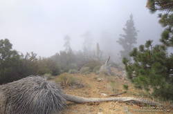
When I started up the trail from Vincent Gap (6585′), the thermometer on my pack read 36°F. For the first few switchbacks, the trail was immersed in cloud. Beneath the tall conifers, the sandy soil was dotted with droplets of moisture extracted from the fog.
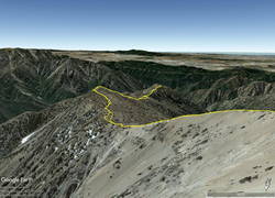
Google Earth image of GPS track down the South Ridge of Mt. Baden-Powell to Ross Mountain
I was on my way to Ross Mountain (7402′), one of the most isolated peaks in the San Gabriel Mountains. At the end of a rugged, 3-mile ridge extending south from the summit of Mt. Baden-Powell, the peak overlooks the vast canyons of the Sheep Mountain Wilderness.
This morning, the canyons were filled with a 7000′ deep layer of stratus clouds. With a weak upper low over the Southern Sierra, the question of the day was whether the cloud deck would work up the ridge from Ross Mountain and completely envelop Baden-Powell.
Summit of Mt. Baden-Powell. May 16, 2021.
Well acquainted with the trail up Baden-Powell, a combination of fast-hiking and slow-jogging put me on top in a relatively comfortable 90 minutes. I’d tried not to overdo the pace, knowing from previous experience that the return from Ross Mountain would be the tough part of the day.
From the summit of Baden-Powell, I gazed across the sea of clouds to Mt. Baldy. There was almost no snow on its steep north face. San Gorgonio Mountain was visible in the haze to the left of Pine Mountain and San Jacinto Peak in the gap between Dawson Peak and Mt. Baldy.
South Ridge of Mt. Baden-Powell with Ross Mountain partially visible in the clouds
Walking a little down the south side of Baden-Powell, I got my first good look at the South Ridge. Ross Mountain was nearly covered in clouds. Guessing that the deck of clouds might deepen, and a few minutes might make the difference of being in the clouds or out, I started to jog-lope-shuffle down the initial steep slope.
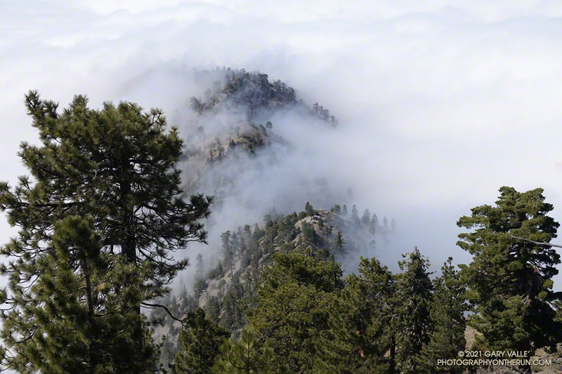
The title photo was taken a bit past Peak 8375, about 1.7 miles from Baden-Powell and 1.2 miles from Ross Mountain. At that time the clouds were spilling over the ridge near Peak 7407 and Peak 7360+, and around Ross Mountain.
Into the clouds near Peak 7407
The clouds added an aesthetic element to the adventure, as well as a little uncertainty. They accentuated and embellished the terrain, while threatening to make the conditions wet, cold and disorienting. Being familiar with the route helped me to enjoy the experience more than the concerns.
After navigating the false summits along the final stretch of ridge, I finally reached Ross. And, of course, it was in the clouds. That was the tradeoff for the spectacular views of the clouds along the ridge.
I didn’t spend much time on the summit. The more time I could spend out of the clouds, the more enjoyable would be the 2200’+ climb back to Baden-Powell.
It took a little over two hours for the clouds to chase me back up the ridge, but only an hour to run the four miles down from Baden-Powell to the foggy trailhead.
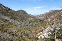
Twin Peaks and Mt. Waterman from the Hawkins Ridge Trail
Don’t let there be a headwall… Don’t let there be a headwall… That’s what I kept muttering to myself as I climbed up the decomposing granodiorite rib. The topo map showed the rib connecting directly to the crest, but from my vantage point I couldn’t tell if that was actually going to happen.
So far the the difficulties had been manageable. The route had been steep and loose, but for the most part it was at an angle that probably wouldn’t result in a long fall or slide. Probably. But if it got any steeper it could be a problem, and I really didn’t want to downclimb 1200′ of crumbly rock and loose debris.
Working up the rib I had gone from “secure spot to secure spot,” trying to minimize my exposure in between. In a few places a climbing move had been required to avoid disturbing fractured or delicately balanced rocks. On one section it had been necessary to crawl through a mountain mahogany, its stiff limbs poking fun at my route-finding. Higher up, the solid handholds of a massive gray boulder had helped to ascend a particularly loose section.
Crystal Lake Recreation Area from the crest near Peak 8426
As I climbed, I considered alternative routes, surveying the terrain to my left, right, and along the crest. I couldn’t help but wonder if there was a better line. But I needed to be patient. The rib was working and I just needed to stay on it.
I tried to recall if I’d ever been on anything like this. I’d certainly done a few class 2 descents on Sierra peaks that were loose. The closest comparison might be some of the “knapsack passes” in the Sierra. These are usually class 2 or class 3 routes that go over notches and connect one high basin to another. They are often steep, loose and wet, and can hold snow or ice throughout the Summer.
And then suddenly I was on top. There was no more rib to climb. While I enjoyed the problem solving, it’s not a climbing route I would recommend, and I probably won’t repeat it.
South Mt. Hawkins and Sadie Hawkins from the Hawkins Ridge Trail
Climbing the rib was my overly-creative way of doing a loop that included the Hawkins Ridge Trail. I’d done Middle Hawkins (Peak 8505′) as a side trip on a run from Islip Saddle to Baden-Powell, but had not gone down the ridge as far as Sadie Hawkins (Peak 8047′).
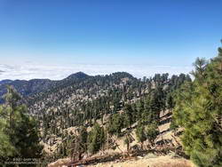
It was the perfect day to be running the Ridge Trail. The weather was far better than during my last run in the area. Temps were about 20 degrees warmer, and while it was still breezy, the wind was nowhere near the strength of a couple weeks ago. A sea of marine layer stratus filled the valleys and extended into San Gabriel Canyon, providing an “above the clouds” backdrop befitting of a mountain trail.
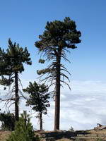
Pines on Hawkins Ridge that survived the 2002 Curve Fire
Winding down the use trail from Sadie Hawkins, I rejoined the main Hawkins Ridge Trail and followed it down to the saddle between Sadie Hawkins and South Mt. Hawkins. Two weeks ago, I’d followed the road up to South Hawkins and then descended the north ridge directly. This time I ascended the Hawkins Ridge Trail, carefully following the trail. I was surprised to find it didn’t ascend the north ridge directly, but wrapped around the west side of the peak.
Later, as I ran down South Mt. Hawkins Trail/Road, I thought about the amount of rocky debris along and on the road. It emphasized the friable nature of the rock above, and how often there are larger rockslides. When I reached the point on the road where I could see the route I’d climbed, I just shook my head. Who the heck would want to go up there?