Following our five year drought, Downtown Los Angeles and many neighboring areas recorded above-average rainfall in two of the last three rain years. This has had obvious and observable effects on the area’s plants and animals and aided in the ongoing recovery of habitats affected by drought and wildfire.
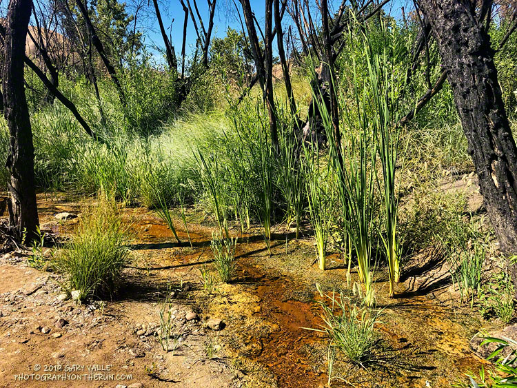
This is the first time since the Summer of 2011 that there has been flowing water in upper Las Virgenes Creek in mid-July at the crossing near the Cheeseboro connector. It’s just a trickle, but keep in mind that during some of the drought years, this section of upper Las Virgenes Creek never flowed.
Update November 19, 2019. Increased surface water and pooling in Upper Las Virgenes Creek. See the post Running Into Fall.
Update August 28, 2019. The surface flow of Upper Las Virgenes Creek near the Cheeseboro connector is down to a bare trickle and some small pools.
Update August 7, 2019. Upper Las Virgenes Creek is still trickling.
Notes: In rain year 2016-17 Downtown Los Angeles (USC) recorded 19.00 inches of rain from July 1 to June 30, and in 2018-19, 18.82 inches. During the intervening rain year, 2017-18, only 4.79 inches was recorded.
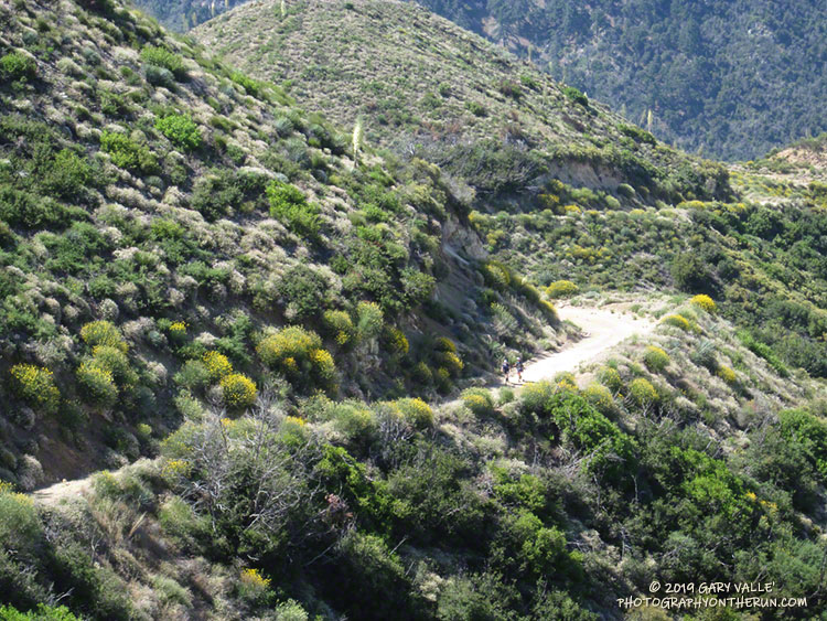
Runners working up Josephine Fire Road from the Clear Creek Aid Station.
The race was going well. We’d made the 3:05 p.m. cutoff at West Fork (Mile 26.5 of the 50K) with an hour to spare and I was feeling good. One reason was that temps for the race were not nearly as hot as in 2017 and 2018. For the most part heat had not been an issue. Even so, with the clear sky and strong sun, it had still been toasty on the climb up to Lawlor Saddle and descent from Red Box.
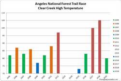
High at Clear Creek for the 2005-2019 ANFTR/Mt. Disappointment races. Click to enlarge.
On the way down from Red Box, I’d started running with German, who was running the Angeles National Forest Trail Race (ANFTR) as his first 50K. He’d run the Los Angeles Marathon a few months before and was curious to see what ultras were all about. He knew he’d picked a good one. I told him the ANFTR/Mt. Disappointment 50K was a favorite, and one of the best organized races that I had run.
Born in the ingenious mind of RD Gary Hilliard in 2005, the ANFTR/Mt. Disappointment races are unique. Most mountain ultras start low, climb to one or more high points, and eventually descend to the finish. The ANFTR/Mt. Disappointment courses do the opposite. They start on top of Mt. Wilson, and many miles later, finish with a grueling 5.5 mile, 2600′ climb from West Fork back to the top of Mt. Wilson.
We’d refilled at West Fork, taken a couple of minutes to cool down, and then had continued west on the Gabrielino Trail, jogging the level stretches and avoiding the poison oak prevalent on that section of trail. Reaching the Kenyon Devore Trail, I said something like, “The fun begins!” and we headed up the steepening trail. Both of us had done Kenyon Devore recently in training, and I’d done it many times in previous ANFTR/Mt. Disappointment races.
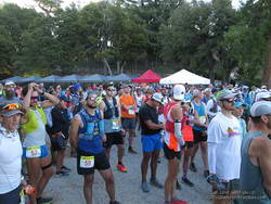
60K, 50K and 25K runners at the Starting line for the 2019 Angeles National Forest Trail Races.
I felt the first twinge around mile 29. Just a little flicker in an adductor. I’m used to this. Although I’ve not had any chronic mechanical issues with my knees and feet, in about two-thirds of my 50K and longer races I’ve been hit with leg cramps. Researchers refer to this type of cramping as Exercise-Associated Muscle Cramps (EAMC).
EAMC is no fun at all. The cramps, usually in the active leg muscles, can be intense and painful. They often occur late in a race — right around the time you’re getting excited about finishing and want to pick up the pace on the final few miles of the course. They are disconcerting and frustrating.
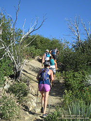
Working up the San Gabriel Peak Trail on the first uphill of the ANFTR course.
I’ve researched EAMC for many years, followed the science, and tried many remedies and solutions. Everyone has their favorites. Two of mine are pickle juice and jalapeño chips. Nothing I’ve tried has worked reliably and the research I’ve reviewed suggests there is no magic bullet for dependably preventing this type of cramping.
Much has been written about EAMC. Following are links to a couple of papers that summarize some of the research:
Like many who experience EAMC, I seldom get cramps in training runs — even very long and difficult training runs. For those of us that are prone to cramping, there are a multitude of interrelated factors that determine if cramping occurs, and if it does, how severe the cramps will be.
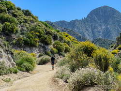
Strawberry Peak looms in the background as a runner works up Josephine Fire Road.
The most common scenario for me is that somewhere in the last few miles of a race I will feel a twinge in an adductor or hamstring. I’ll stretch; drink more water; maybe take an electrolyte tab or two and continue. Sometimes that will be that, but more often than not, the twinges develop into a familiar cycle of disruptive cramping — a sequence of the adductor and hamstring muscles in one leg cramping, followed sometime later by the adductor and hamstring in the other leg.
Once cramping starts, I walk. In my experience, walking usually helps to alleviate the cramping, particularly on level and downhill sections. If I can keep moving the cramps will often resolve in a few minutes. Then I can continue more or less normally, and can go back to running. Once the cramps have cycled through both legs, they usually don’t reoccur.
This time around I’d continued to feel various twinges, and then around mile 30, WHAM! It felt like every muscle in both legs cramped at once. I had no choice, but to sit down in the middle of the trail.
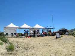
Josephine Aid Station
I’d been telling German about my cramping woes, so he wasn’t caught totally off guard. In the middle of all the drama, I kept saying I had to get up and get moving — not because I was worried about the time — but because I thought it would help resolve the cramps. At one point the cramping started to subside, but just trying to stand up was enough to trigger them again.
Eventually I was able to stand and slowly start hobbling up the trail. It seemed like I had been sitting for a long time, but according to my GPS track, we were only stopped for about 5 minutes.
At first, I had to be very careful about re-triggering the cramps. There were a few places where the trail steepened, and I could feel I was on the brink of cramping again. Keeping a constant, easy pace that didn’t overtax any individual muscle group was key. Gradually, I was able to resume a more normal gait. Not wanting to cramp again, I kept the pace slow.
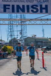
German and me at the Finish. It was German’s first 50K.
My legs behaved for the remainder of the climb, and German and I happily reached the top of Mt. Wilson and crossed the finish line with a smile. We even jogged the last few steps! I congratulated him on finishing his first 50K and thanked him for hanging with me through the cramping episode. After finishing, I walked around for about 10 minutes. In my experience this helps to keep the post-race cramps at bay, and they didn’t reoccur.
As in every race in which I’ve cramped, I’ve asked myself what I might have done differently. I was heat-acclimated. I did several ANFTR-specific training runs starting and finishing at the top of Mt. Wilson. Maybe these runs could have been longer, done at a faster pace, or in combination with another strenuous run — with the idea of being more fatigued on the climb back up the peak. My fueling and hydration seemed to be pretty good, but maybe I need more carbohydrates and fluids than I think. I tapered normally, but have noticed in other races that less of a taper may help with cramping. One thing that might have really helped on this course is the use of trekking poles.
Follow-up December 2019: I had no cramping at all during the Kodiak 50K in August, but did have some moderate leg cramps during the Rocky Peak 50K in October.
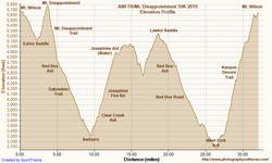
Elevation profile of the 2019 ANFTR/Mt. Disappointment 50K.
This was my twelfth finish of the ANFTR/Mt. Disappointment 50K. It is a challenging, superbly organized race on a spectacular course. Many, many thanks to RDs Gary & Pam Hilliard; the aid station and ham radio volunteers; Sierra Madre SAR; Angeles National Forest; the race sponsors; and all those that make this such an outstanding event.
Was back on Mt. Wilson this morning, enjoying the mountains, and getting in a little more training for the upcoming Angeles National Forest Trail Run races.
There were already two cars parked in the loop road turnout when I got there, and another car pulled in behind me. All were runners.
The turnout is near the start of the ANFTR course and most of the runners were planning to do the ANFTR 25K loop or a variation. One runner — training for the ANFTR 60K and AC100 — was doing the 50K course.
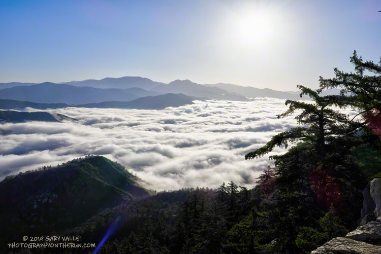
The extensive layer of low clouds in the canyons of the West Fork and East Fork San Gabriel River at the start of the run was indicative of a cool onshore flow. Too cool and comfortable, really. Anticipating warmer temperatures for the ANFTR race, I wore an extra layer for the run, and probably should have worn more.
The last two years the ANFTR races have been run during record-setting heatwaves. We’ve had a lot of cool weather this year and for a while it looked like the pleasant weather might carry over to race day, July 6. But following the finest of ANFTR/Mt. Disappointment traditions, it now looks like temps will probably be warming up for the race. Maybe not quite as hot as the last two years, but still on the toasty side. We’ll see!
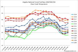
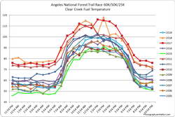
High at Clear Creek for the 2005-2019 ANFTR/Mt. Disappointment races. Click to enlarge.Hourly Clear Creek temperatures for 2005-2019 ANFTR/Mt. Disappointment races. Click to enlarge.
Update Thursday, July 11, 2019. As it turned out, temperatures for the 2019 edition of the Angeles National Forest Trail Run were in the “middle of the pack” compared to other years. The high temperature recorded at the Clear Creek RAWS on July 6 was 80°F. This was down 25°F from 2018. Hourly fuel temperatures at Clear Creek ranged from 101°F to 104°F between noon and 5:00 pm. The high at the Mt. Wilson RAWS on July 6 was 75°F, down 20°F from 2018.
Hourly Clear Creek fuel temperatures for the 2005-2019 ANFTR/Mt. Disappointment races. Click to enlarge.
Note: The temperature in a commercial weather station is measured inside a white, ventilated instrument housing, several feet off the ground. Mid-day temperatures in the sun, in the summer, with a cloudless sky will be much warmer than this. Some stations, such as Clear Creek, also measure the fuel temperature — the temperature of a pine dowel in direct sun about a foot off the ground. According to the NWS (and common sense) exposure to full sunshine can increase heat index values by up to 15°F. In my experience the fuel temp gives a better indication of the actual temperature a runner can experience in the sun, especially on exposed mountain slopes facing the sun.
Update Monday, July 1, 2019. Last week the GFS weather model was forecasting temps on race day to be near 100 at the lower elevations and over 90 on Mt. Wilson. This morning’s GFS max temperature forecasts are down about 10 degrees from that. Basically highs in the low 90s (in the shade) for the lower elevations and around 80 at Mt. Wilson. Temps in the sun, especially on exposed sun-facing slopes, could still top 100. If the forecast holds, the temperatures today should be similar to those on race day. We’ll see! Here are links to the Clear Creek RAWS and Mt. Wilson RAWS.
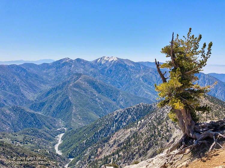
Each year, around Memorial Day, I like to do the out and back on the Pacific Crest Trail from Islip Saddle to Mt. Baden-Powell. It’s fun to see how much snow (if any) remains on Mt. Baden-Powell and to get an idea of how much snow there is on Mt. Baldy, San Jacinto Peak and San Gorgonio Mountain. It’s also a good way to continue acclimating to higher elevation.
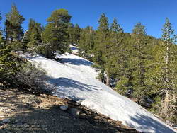
Snow at 8750′ near the junction of the PCT and Dawson Saddle Trail
This year I was a couple of weeks late getting to Baden-Powell, having done runs on Mt. Wilson Memorial Day weekend and Mt. Waterman the weekend after. That’s OK, over much of the holiday weekend it was cold and snowy at the higher elevations of the local mountains. The temperature at the Big Pine RAWS (6964′) was in the thirties all day Sunday, May 26, and it was certainly much colder than that at 9400′ on Baden-Powell.
There were no worries about snow flurries and cold weather today! The weather was perfect for the run. Cool in the shade and warm in the sun.
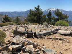
Summit of Throop Peak.
In some places between Throop Peak and Baden-Powell, there was still snow on the trail, but it could be avoided by moving to the sunny side of the crest. The last time there was more snow here in late May – early June was in 2010.
Perhaps because of the more seasonable weather, there were many (mostly) happy people on the trail that, like me, were thoroughly enjoying the wonderful day.
When I left the house to drive over to Ahmanson Ranch, the temperature in West Hills was 92 °F. It had been five months since it was that warm.
It’s been my experience that the first hot weather of Spring is often associated with an uptick of snake sightings. Over the past seven days or so, I’d seen a very young rattlesnake and a couple of small gopher snakes, but so far, that was it. With the warm weather, I thought I might see a snake on my run today, I just didn’t expect it to be in this manner.
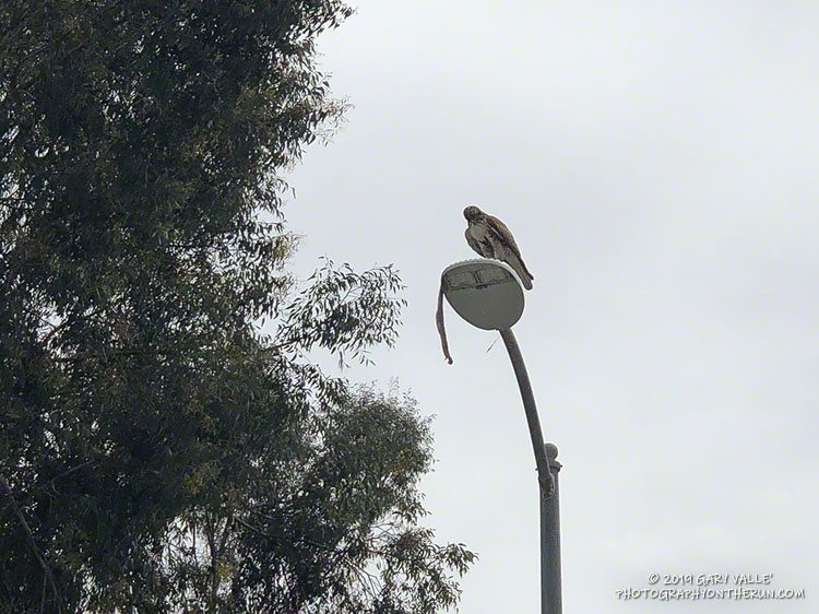
Lost in thought, I was just about to the entrance of Upper Las Virgenes Canyon Open Space Preserve (aka Ahmanson Ranch) when I was startled by a large red-tailed hawk flying from right to left directly in front of me. Something long was dangling from its talons.
I stopped and watched as the raptor, fumbling with a large snake, awkwardly flew onto the top of a street light. The snake was dangling precariously from the light, and the bird seemed to be having a little trouble holding it.
The snake looked relatively heavy-bodied, and at the time I thought it might be a rattlesnake. That brought to mind a story of a hawk somehow dropping a rattlesnake into a car. However improbable, I didn’t want to approach the hawk and frighten it. I have enough problems with rattlesnakes on the ground and don’t need them falling from the sky.
I got what photos I could with my phone and headed out for a run.
You know how it is when you’ve seen a snake — anything sinuous on the trail sets off the brain’s snake alert. During my run I saw a couple of stick snakes, but no real ones. Finishing my run, I pressed the Start/Stop button on my watch and started walking across the parking lot.
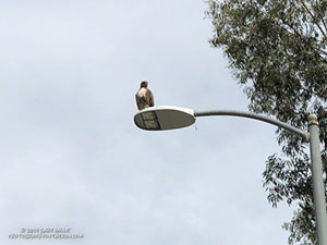
Red-tailed hawk waiting to retrieve a dropped gopher snake.
What? I squinted my eyes… Was the hawk still perched on the street light? No way, more than an hour had passed!
Continuing across the parking lot, I could see the hawk was still there, but where was the snake?
Cautiously, I approached the light post. I didn’t want to agitate the hawk or stumble onto an upset rattlesnake.
Sometime during my run, the hawk had dropped the snake — a gopher snake — and was waiting to retrieve it. It lay upside down on the street — sans its head. Rattlesnake or not, the hawk had removed the dangerous bit first.
I’ll be curious to see if the snake is still in the street tomorrow.
Update April 11, 2019. The following day (Tuesday) no trace of the snake remained, but the red-tailed hawk was still there — perched on an adjacent street light. On Wednesday the bird was gone.
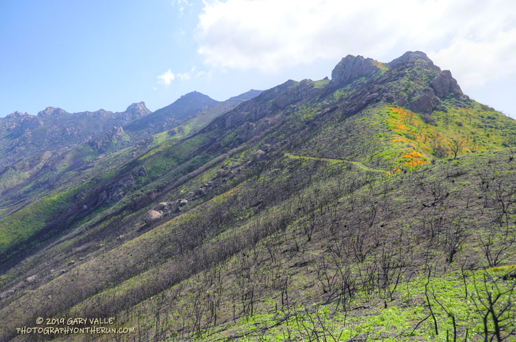
The sun had not yet risen and the poppies along Danielson Road were still tightly furled against the morning’s chill. The purl of Upper Sycamore Creek resonated in the canyon below — a wonderful tone that in recent years has too often been squelched by drought.
I was running to the Old Boney Trail and the start of the ridge that follows along Boney Mountain’s western escarpment to the massif’s huge summit plateau. Several of the Santa Monica Mountains highest peaks are on this plateau, including the range’s highest peak, Sandstone Peak.
In December I’d climbed this route to check the impact of the Woolsey Fire on the area. From the top of the ridge I’d been disheartened by what I saw. Tri Peaks and Sandstone Peak and much of the top of the Boney Mountain massif were a blackened, barren mess.
Now, three months later, I was headed back to Boney Mountain and would continue to Sandstone Peak for the first time since the fire.