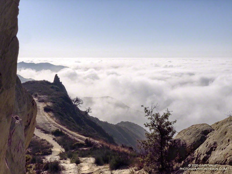
Marine layer clouds from the Backbone Trail at “Mammoth Pass.”
The Bulldog Loop, without any extras, is a little over 14 miles long, with an elevation gain of about 2700′.
While doing the Phantom Loop last week, I was reminded that a good way to extend the Bulldog Loop is to combine it with the Phantom Loop. This produces a run of about 19 miles, with an elevation gain of around 3650′.
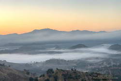
Early morning view of Saddle Peak from the Cistern Trail
This weekend I was looking to do something a little longer. With the National Forests in Southern California still closed, the usual high country options weren’t available. The temperature forecast looked warm, but not crazy hot, so it was a good day to do this run.
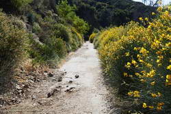
The Cistern/Phantom Trailhead on Mulholland Highway is a convenient place to start and end the loop. Later in the run, water is usually available from a faucet and fountains adjacent to the restrooms at the main MCSP parking lot. If doing the loop counterclockwise from the Cistern Trailhead, the restrooms and water are about 14 miles into the run.
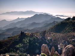
Santa Monica Mountains from the top of the Bulldog climb.
The main attraction is still the Bulldog climb. From Crags Road to Castro Mtwy, the Bulldog Mtwy gains about 1730′ over about 3.4 miles. From the MCSP parking lot to the high point on the Phantom Trail, the route gains a bit more than 1000′ over 4.7 miles.
A coast redwood stands above the other trees near Century Lake.
It was a chilly 45°F as I crossed algae-covered Malibu Creek on a foot-worn log. Following a brutally hot Summer with temps in the West San Fernando Valley reaching 121°F, the chill of the cold air felt especially good.
The plan was to do the Phantom Loop, but first, I was going to run over to the Forest Trail. The side trip was not only to check on the coast redwoods along the trail but to enjoy the calm beauty of the area. To say 2020 has been unsettling is like saying a rattlesnake bite is a little annoying — and the year isn’t over yet.
Coast redwood near the Forest Trail and Crags Road junction
Continuing along the Forest Trail toward Century Lake, I counted four healthy-appearing redwoods and two struggling trees. Redwoods sometimes grow in a group of two or more trees, and these were counted as a single “tree.” Near the end of the trail is a naturally-germinated redwood that has grown to about 5.5 inches in diameter. Remarkably, this young tree survived the 2011-2015 drought and the 2018 Woolsey Fire, and appears healthy!
I had just finished photographing the young tree when a Cooper’s or Sharp-shinned Hawk flew from a nearby oak and through the trees along the trail. It landed on the limb of an oak ahead of me but was in deep shade. In a much-enlarged image, the bird looks like a Sharp-shinned Hawk, but distinguishing the two species can be challenging.
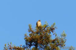
Red-tailed hawk atop a coast redwood.
A few yards down the trail, a much larger raptor — a Red-tailed hawk — was perched at the top of the tallest redwood. The huge bird had its wings pulled back to expose more of its body to the warming sun. It looked like a giant penguin sitting atop a tree. As I approached, it began to preen its feathers, comfortable with its lofty position.
With a sigh, I left the Forest Trail behind and returned to Malibu Creek. This time I crossed the creek on a plank near the washed-out bridge. This was a more direct route than the fallen tree upstream but only worked because the creek was low. At the crossing, a passing runner asked if he was on the Bulldog Loop. I assured him he was and was a little envious that he was getting to experience that excellent run for the first time.
Morning view of Goat Butte and stream course of Malibu Creek
As usual, Crags Road and the High Road were busy thoroughfares. The easy running under the sprawling coast live oaks was pleasant, and the morning view of Malibu Creek and Goat Buttes outstanding.
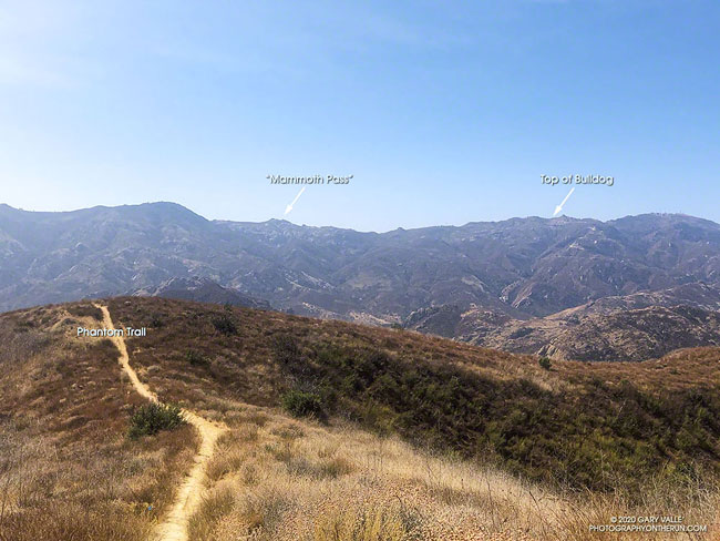
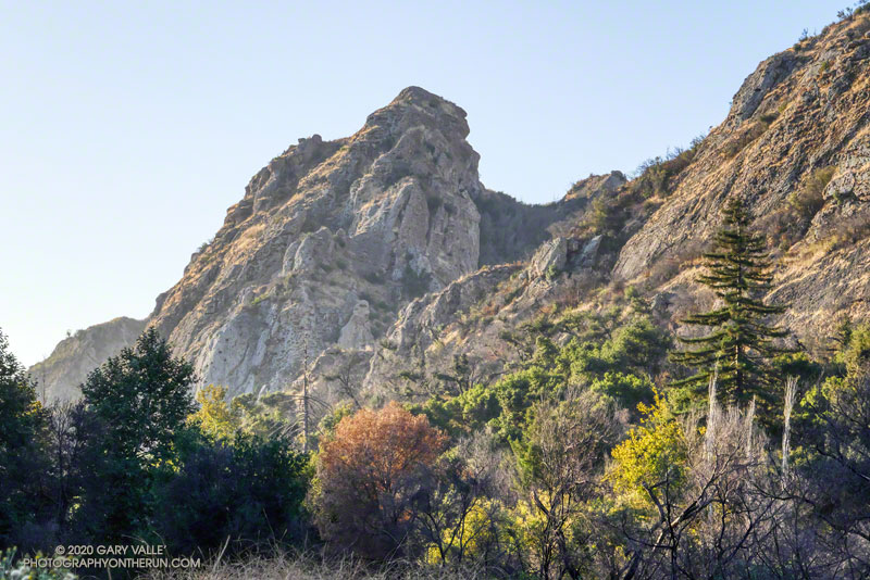
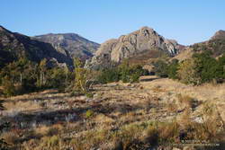
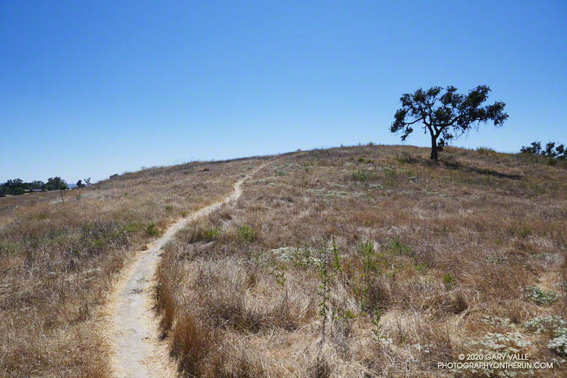
In a few minutes, I’d reached Mulholland Highway and then followed the Grasslands Trail to the Liberty Canyon Trail. From Liberty Canyon, the Phantom Trail gains about 750′ in elevation over about 1.5 miles to a high point and ridgeline with excellent views of Saddleback Peak, Las Virgenes Canyon, Brents Mountain, Goat Buttes, Castro Peak, Ladyface, and Boney Mountain.
The air quality this morning hadn’t been too bad. From up on the ridge, I could see there was far less smoke to the west of Las Virgenes Canyon than to the east. Yesterday, I’d done a run in the eastern Santa Monica Mountains and had to cut the run short because of smoke. That wasn’t a problem today, and the run had been a good one.
If today’s forecasts hold, it looks like Southern California could be in for a multi-day bout of very hot weather. Not only is the weekend forecast to be hot, but next week could be hot as well.
With the addition of Southern California Edison’s 480+ weather stations to existing NWS, RAWS, APRSWXNET/CWOP, and other networks, it’s now possible to find the temperature near many trails and trailheads in Southern California.
Below are MESOWEST links that will display maps with the temperatures recorded in the last hour. You’ll need to click the “View Profile Without Logging In” button to display the map. It isn’t necessary to join MESOWEST to display the map.
In most cases wind, solar, and humidity/dewpoint data are available as well as temperature. Some stations include precipitation and fuel temperature. You may need to drag the map to see a particular station. Click on a station icon for more info.
After so many years of doing the Angeles National Forest Trail Race, I’m not sure I even had a choice. At about 7:00 a.m. on Saturday, July 11, 2020, I found myself running down Mt. Wilson Road.
It was odd not to be surrounded by runners. Gary Hilliard had not done his one-of-a-kind pre-race briefing. There had been no hugs or handshakes at the start of the run. No runners commented on the temperature or talked about past or future races. Thanks to COVID-19, the 2020 ANFTR race had been canceled.
But the mountains and trails were still there, and by running the 25K course, I could get a good idea of what the 2020 race might have been like.
I was not racing the course. The forecast was — of course — for a hot day. And in these covid times, I was running solo. I was out to enjoy “being there” — seeing what I could see, learning what I could learn.
View into the canyon of the West Fork San Gabriel River from Mt. Wilson Road.
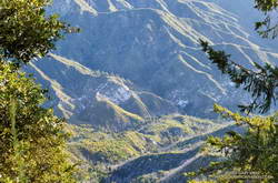
Mt. Wilson road is exceptionally scenic, and on the way down to Eaton Saddle, I stopped several times to take photos. The canyon of the West Fork San Gabriel River is spectacular. It’s a long way down to the bottom, and I always marvel at its depth. The 2600′ climb out of that canyon is the crux of all the ANFTR courses, and as I would later discover, would be especially challenging today.
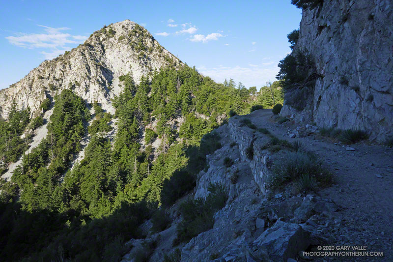
Rugged San Gabriel Peak marked the turn onto Mt. Lowe fire road at Eaton Saddle. From here, the course follows the fire road through Mueller Tunnel and up to the saddle between Mt. Markham and San Gabriel Peak. The first significant climb of the course begins here. Much of the 650′ climb up the single-track trail is in the shade. If it’s already warm here…
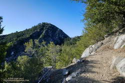
Looking back at San Gabriel Peak from near the top of the Lower San Gabriel Peak/Bill Reilly Trail.
The single-track trail leads up to the Mt. Disappointment service road. The high point of the 60K, 50K and 25K courses — about 5780′ — is along this short stretch of road. For the 25K course it’s (almost) all downhill from here to West Fork. A winding, and usually dusty, single-track trail turns off the service road and leads down through scrub oaks to Mt. Wilson Road, just above Red Box.
In the actual event, runners doing the 50K and 60K turn left onto the Gabrielino Trail at Red Box and do a 15+ mile circuit around Strawberry Peak. Runners doing the 25K turn right and continue down Rincon – Red Box Road to West Fork.
Spanish broom along Rincon – Red Box Road near Valley Forge Campground.
The time of day when you do the 5+ mile segment from Red Box to West Fork makes a huge difference. On hot race days, such as in 2012, 2017 and 2018, the road bakes and in-the-sun temps can reach well over 100 degrees. (This isn’t the only part of the 50K/60K course that can be hot!)
Because I was running the 25K course, I was on Red Box road relatively early. It was probably in the 90s in the direct sun, but there were still some cool stretches of shade. In years with average or above-average rainfall, there are usually a few little stream crossings where capfuls of water can be dumped on your head. They were flowing today. Usually at West Fork there is a hose/shower setup to use for cooling.
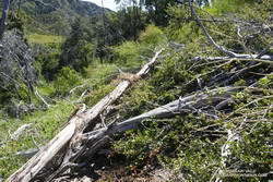
There was a collapsed sycamore on the trail near the spring, but it didn’t look like it was going to be much of a problem. On the run down to West Fork, I’d noticed an increasing number of trees on the road. About a mile from West Fork, a large oak had fallen down a road-cut, blocking the road and bringing with it a pile of debris.
Mass of trees down on the Gabrielino Trail.
Leaving West Fork on the Gabrielino Trail, I worked around the fallen sycamore and then continued up the trail. Within yards there was another fallen tree, then another, and another. The number of trees down on the trail was remarkable. Part of the reason is that the Forest Service isn’t currently allowing volunteer groups to do trail maintenance. I’m sure ANFTR R.D. / AC100 Trail Boss Gary Hilliard is going crazy not being able to work on the trails.
But I think there’s more to it than trail maintenance. There are far more trees down on the trail than I’ve seen in other years. The area is covered in scrub oaks and bay trees that were killed by the Station Fire. I suspect the same storms that broke and toppled trees in the San Gabriels high country over the Winter, toppled dead trees here as well.
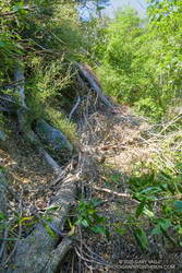
Trees down on the Kenyon Devore Trail.
It became a mantra — over, under, around or through? Over, under, around or through? Tree after tree. It was warming up, and the extra work of battling the trees added to the effort. On the Gabrielino segment of the route, trail users had trimmed some small limbs from a few of the trees, and that helped.
I thought that once I got out of the scrub oaks and into the forest proper, there wouldn’t be so many trees on the trail. That was mostly true, but there were still several tree challenges higher on the Kenyon Devore Trail. One large log was perched across the trail at the top of a steep gully. I didn’t want to slip and started to use the log for hand-holds. Bad idea! Who knew how little force would be required to dislodge the tree.
Eventually, I reached a point on the trail where I could just hike and didn’t have to climb over, under, around or through anything. What a relief!
It’s difficult to estimate just how many trees were down on the trail. Fifty? Sixty? I have no idea. There were many small trees I didn’t even think about, and there were multiple trees down in some spots. However many there are, if another Winter passes before the trails can be maintained, it will require a massive effort to get them cleared.
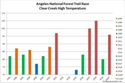
The highest temperature recorded at Clear Creek on the day of the ANFTR/Mt. Disappointment races for 2005-2020. The 2020 race was canceled.
Based on the temperatures recorded at the Clear Creek RAWS, this would have been the #3 or #4 hottest of the ANF Trail Races. Compared to the other hot races, temps were a few degrees cooler early, but reached similar temperatures by mid-afternoon. The Clear Creek RAWS recorded hourly temperatures as high as 96°F and hourly fuel temps as high as 121°F.
The out and back to Mt. Baden-Powell from Islip Saddle has become a springtime running ritual for me. Sometime in April, May or June, I like to get back to the high country, and see what there is to see — including whether there’s any snow left on Baden-Powell or Mt. Baldy.
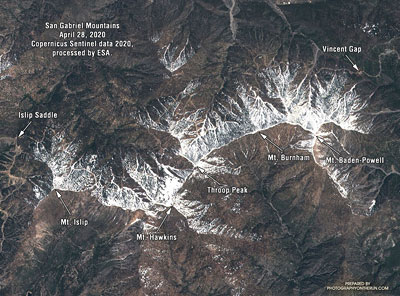
Snow in the San Gabriel Mountains, April 28, 2020. Click for larger image.
Sentinel satellite imagery showed a lot of snow along the crest at the end of April, but hot weather and dry winds in May accelerated the melt. By early June most of it was gone. It didn’t seem likely I would see any today.
I hadn’t seen any snow along the trail this morning. I’d run past Little Jimmy Camp, Windy Gap, Peak 8426, and was now at an elevation of about 8700′, near Mt. Hawkins. Above me, I could hear the excited voices of a couple of hikers near its summit. Thinking they might be part of a group, I looked up the trail toward the crest.
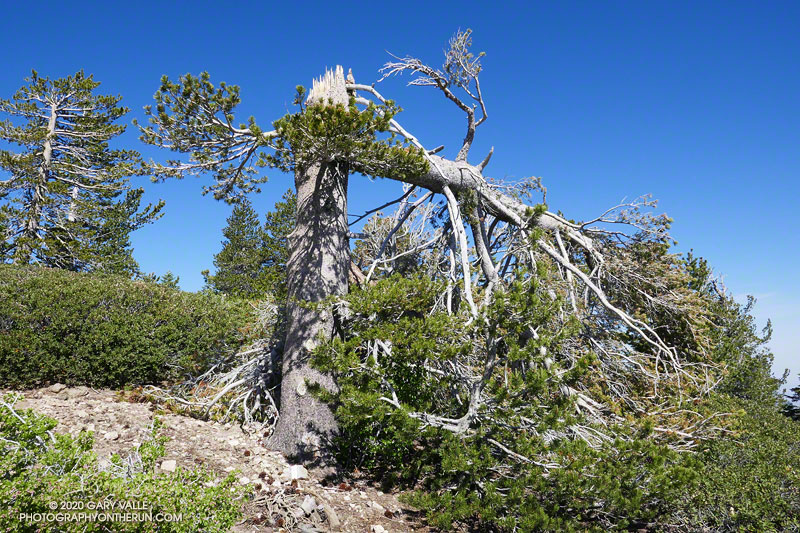
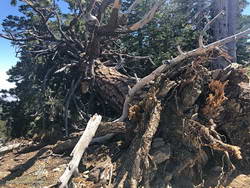
Something was missing… Where was it? Usually prominent on the skyline at this point, the “Mt. Hawkins Lightning Tree” was gone. I walked up the trail to look for the familiar landmark. The trunk of the lightning-scarred Jeffrey pine had been snapped like a twig. The crown of the tree lay 50 yards down the steep slope, jammed against two trees.
Jeffrey pine near Mt. Burnham, toppled by Winter winds.
It must have been a hard Winter. Several other live trees along the crest between Mt. Hawkins and Mt. Baden-Powell were either blown down or broken in half. In some cases, the damaging winds appeared to be from the south side of the crest and in others from the north. December 2019 was stormy in Southern California, particularly around Christmas. Weather data suggests this might have been when most of the damage was done.
Today, only two large trees blocked the trail. One, on the west side of Mt. Burnham, was easy to go under or around, but the other, west of Throop Peak, was a bit more of a challenge. Given the brush on either side, climbing over the tree worked for me. Some others had detoured well above or below the tree.
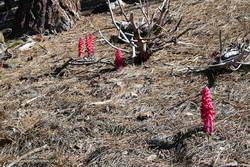
Snow plant along the PCT near Throop Peak.
Surprise, surprise! It turned out there were a couple of small patches of snow on the north side of the crest near Baden-Powell. These were the remnants of an area of wind-deposited snow on the lee (north) side of the crest between Mt. Baden-Powell and Mt. Burnham. Large drifts can collect here, and in a heavy snow year, can persist into July. The deposition area can be seen in the Sentinel satellite image.
With its long views, sub-alpine elevation, and weather-worn limber and lodgepole pines, Baden-Powell is a rewarding summit. Just a few miles to the southeast, Mt. Baldy looms above a mile-deep canyon. If the visibility is good, San Jacinto Peak and San Gorgonio Mountain can be seen beyond Mt. Baldy, many miles in the distance.
The distance from Islip Saddle to Mt. Baden-Powell (9,399′), and back, is about 16 miles. The cumulative elevation gain is about 3800′. Here’s an interactive, 3D view of the out and back route.
Trail note: I ran into a “misplaced” hiker that didn’t know what trail they were on or where they started. Take the time to familiarize yourself with the adventure you have planned!
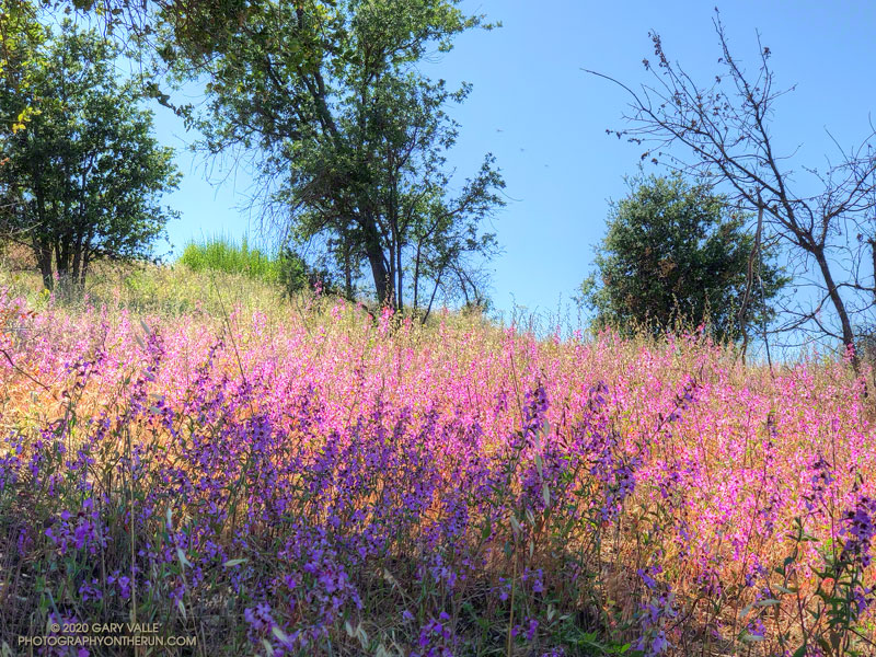
Over many years of running in Upper Las Virgenes Canyon Open Space Preserve (Ahmanson Ranch), I’ve noticed that the height of Elegant Clarkia is closely related to the amount of Spring rainfall. During some years of our most recent drought, the plants were short and scarce.
Spring 2020 was particularly wet in the Los Angeles area. Downtown Los Angeles (USC) recorded 179% of normal rainfall in March, and 332% in April. This was the wettest March and April in Los Angeles since 1992.
This year’s bloom of Elegant Clarkia is the most profuse I’ve seen in Upper Las Virgenes Canyon Open Space Preserve. Look for Elegant Clarkia along the Lasky Mesa Trail and along the Mary Wiesbrock Loop Trail on the north side of Lasky Mesa.
Another Clarkia currently blooming at Ahmanson Ranch is Purple Clarkia (Clarkia purpurea). Look for it along East Las Virgenes Canyon Road/Trail.