Twenty-Plus Years Running the Strawberry Peak Circuit

Large boulder near Strawberry Protreo marking the Colby Canyon Trail.
Can’t miss trail marker on the Colby Canyon Trail near Strawberry Protreo.

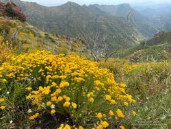
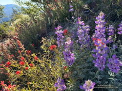
The repeated cries of a falcon called from high on the north face of Strawberry Peak. Along the sandy trail, lupine, paintbrush, penstemon and yarrow bloomed in a profusion of blues, reds, and yellows. Tracks from running shoes, bikes, boots, and a black bear proclaimed the trail to be truly multi-use.

I sighed and took it all in. I’d been doing this classic 16-mile route for more than 20 years. A favorite of mountain bikers and runners alike, the loop can be broken down into the following segments.

Josephine Fire Road Climb
Scarlet bugler along Josephine Fire Road. (thumbnail)
Scarlet bugler along Josephine Fire Road.

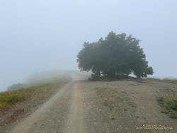
From the Clear Creek Trailhead, Josephine Fire Road climbs about 1250′ over 2.5 miles to a divide connecting Josephine and Strawberry Peaks. At the junction, the route turns right (east) onto a trail along the divide that goes to Josephine Saddle. A left (west) turn goes to Josephine Peak.

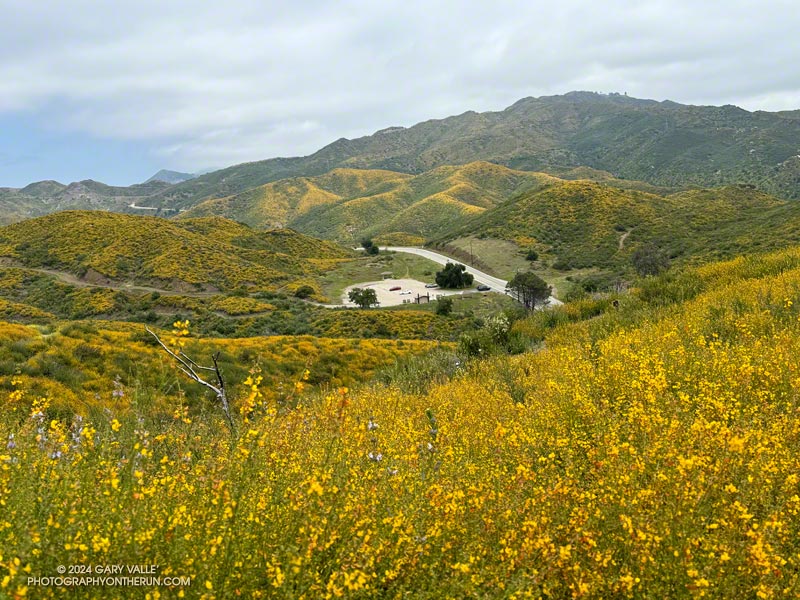
On the way up from Clear Creek, the switchbacks on the fire road look intimidating, but the climb goes relatively quickly. There are good views of Strawberry Peak along the way. In the Spring and early Summer, the bright yellow flowers of invasive Spanish broom line the road.

Clear Creek Trailhead from Josephine Fire Road. (thumbnail)
Clear Creek Trailhead from Josephine Fire Road.

An out-and-back ascent of Josephine Peak from the junction adds about three miles to the loop.

There is a Remote Automated Weather Station (RAWS) at Clear Creek Station. The “2.0m Temperature” is more or less the temperature in the shade and the “Fuel Temperature” is a good indicator of the temperature in the sun.

Colby Canyon Trail
Colby Canyon Trail northeast of Josephine Saddle. (thumbnail)
Colby Canyon Trail northeast of Josephine Saddle.

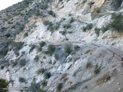
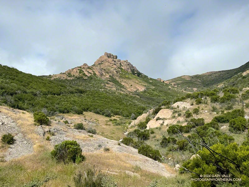
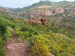
The route joins the Colby Canyon Trail at Josephine Saddle. A large cistern is found here. Just past the saddle, the climber’s trail to Strawberry Peak branches off the main trail and goes up the ridge. The Colby Canyon Trail contours along the left (northwest) side of the ridge and traverses a steep slide area. After that, it works around the shoulder of Strawberry, then turns east and descends, winding in and out of the small canyons on the northwest and north slopes of Strawberry.

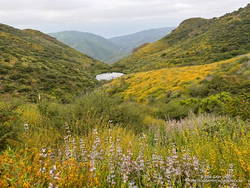
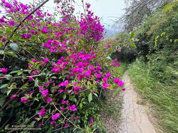
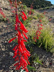
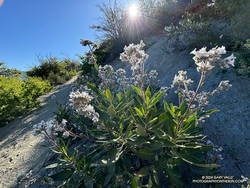
In the Spring and Summer colorful patches of lupine, paintbrush, and other wildflowers are found on this stretch of trail. Long-limbed big cone Douglas-firs grow on these cooler north-facing slopes.

Lupine and paintbrush along the Colby Canyon Trail. (thumbnail)
lupine (violet) and paintbrush (red) along the Colby Canyon Trail.

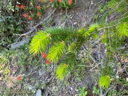
The bare trunks of trees burned in the 2009 Station Fire are mixed in with surviving trees. Today, I was surprised to find another reminder of the Station Fire — poodle-dog bush. The plant can cause a poison oak-like rash and was much more common following the 2009 Station Fire.

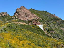
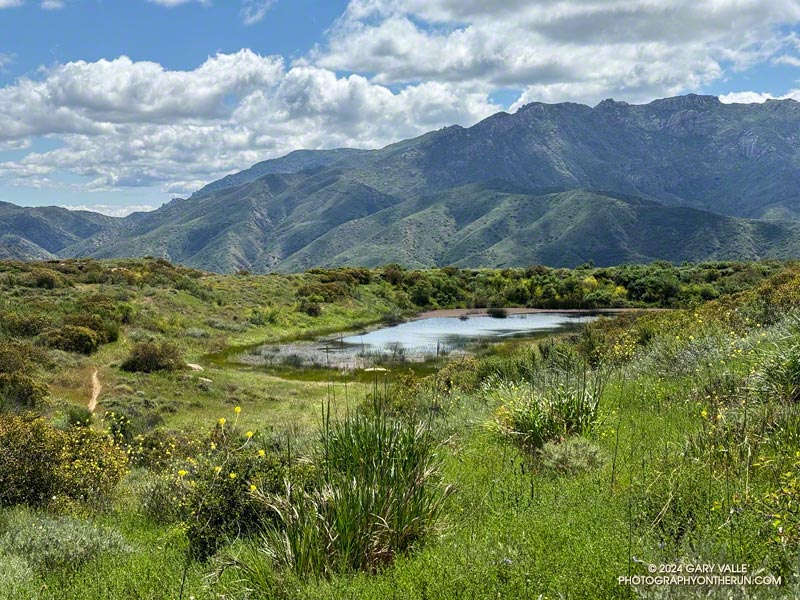
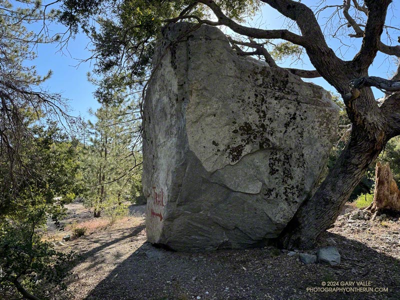
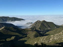
On this stretch, the large rock face on the north side of Strawberry Peak comes into view, and shortly after, the trail passes a huge boulder. The flattish area that follows is Strawberry Protreo. The “meadow” reminds me of lower elevation areas of the Southern and East Side Sierra.

North face of Strawberry Peak. (thumbnail)
North face of Strawberry Peak.

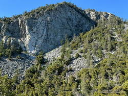
Several climbing routes have been done on Strawberry’s formidable north face. The consensus seems to be that the rock quality is poor and the risk high.

Beyond Strawberry Protreo, the trail descends along the margin of a moraine-like landslide. Then it turns south, reaching a flat, sandy area just before the Colby Canyon Trail – Strawberry Trail junction. I’ve often seen bear tracks on this stretch of trail. The loop takes the right fork onto the Strawberry Trail and climbs to Lawlor Saddle.

Climb to Lawlor Saddle
Yerba Santa along the Strawberry Trail. (thumbnail)
Yerba Santa is a close relative of Poodle-dog Brush.

The Strawberry Trail gains about 750′ over two miles on its way to Lawlor Saddle. As the post “Trail Games” mentions, this stretch will tell you a lot about how your day is going. It dips in and out of side canyons, passing Strawberry Spring along the way. Today, Strawberry Spring was running, but the spring was dry during our recent drought.  It is generally not a dependable water source.

Lawlor Saddle to Red Box
New growth on a bigcone Douglas-fir seedling. May 2024. (thumbnail)
New growth on a bigcone Douglas-fir seedling.

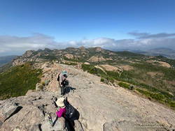
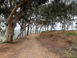
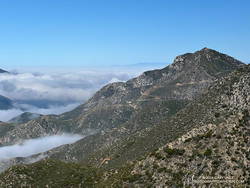
The 2.5 miles to Red Box are enjoyable single-track trail. Most of it is flat or downhill. On the weekend, numerous hikers are on the trail, heading up to climb Strawberry Peak. It is by far the busiest trail on the loop.

There’s a water faucet at Red Box at the Haramokngna American Indian Cultural Center which generally (but not always) has water.

Gabrielino Trail to Switzer’s
Josephine Peak from the Gabrielino Trail between Red Box and Switzer's. (thumbnail)
Josephine Peak from the Gabrielino Trail between Red Box and Switzer’s.

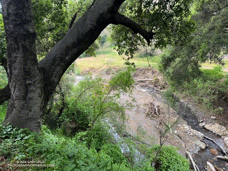
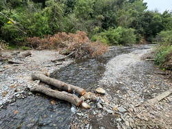
The 4.4 miles down to Switzer’s include some fast-paced stretches and some of the most technical sections of the loop. It is popular with mountain bikers and V-ed and rutted in places. At one point, the trail drops down to the stream (if it’s running) and crosses the creek twice.

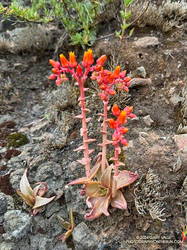
Among the many wildflowers found along this trail is crimson-spotted rock rose.

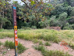
As the trail nears Switzer’s, derelict nature signs are seen along the trail, which the Forest Service apparently can’t afford to repair or remove.

Nature’s Canteen Trail to Clear Creek

The Nature’s Canteen Trail is roughly half a mile long and connects Switzer’s to Clear Creek. It starts a third of a mile up the steep access road between Switzer’s and Angeles Crest Highway. The trail is sometimes overgrown.

Strawberry Peak Variation

There is a more adventurous variation of the Strawberry Peak Circuit that goes over the top of Strawberry Peak instead of around it. This variation requires good route-finding and rock-climbing skills.

This interactive, 3-D terrain view shows the classic Strawberry Peak Circuit and the Strawberry Summit Loop variation.

Some related posts:
Showers on the Strawberry Peak Circuit
Strawberry Peak Summit Loop – Spring 2023 Update
Strawberry Peak Circuit

Encinal Canyon – Mishe Mokwa Loop – Sandstone Peak Running Adventure

Tri Peaks from the Mishe Mokwa Trail. Photography by Gary Valle'.
Tri Peaks from the Mishe Mokwa Trail.

I enjoy doing trail runs with an added element of adventure, exploration, or quirkiness. A run might climb a peak, look for a particular wildflower, or check out a rock formation, a creek, or an old trail. The possibilities are endless.

Whenever I’ve done the out-and-back trail run from Encinal Canyon to Mishe Mokwa, I’ve thought about extending it to Sandstone Peak. Doing so would add the ascent of the highest peak in the Santa Monica Mountains to an already excellent run. Even better, I could run from Encinal Canyon to Mishe Mokwa, do the Mishe Mokwa Loop — including Sandstone Peak — then run back to Encinal Canyon. That would be an exceptionally scenic 26+ miles, with much of it on the Backbone Trail.

An advantage to doing the run this Spring is that back-to-back wet rain seasons have recharged the area’s streams, and I would (theoretically) be able to get water from a creek on the Mishe Mokwa Trail. Another plus is that all the rain has resulted in historic conditions, with extraordinary displays of a variety of wildflowers.

Pond along the Backbone Trail, surrounded by deerweed, black sage. (thumbnail)
Pond along the Backbone Trail, surrounded by deerweed, black sage.

The day dawned overcast and cool, a deep marine layer covering most of the area. I was running west on the Backbone Trail between Encinal Canyon and Mishe Mokwa. The weather could not have been better for the initial 10+ miles of what I hoped to be a challenging and enjoyable run.

Along the way, I marveled at the explosion of wildflowers along the Backbone Trail. In addition to the extensive bloom of deerweed, pitcher sage, black sage, canyon sunflower and purple nightshade lined the trail.

About 8 miles into the run, as the Backbone Trail crossed the west shoulder of Triunfo Peak, a new trail sign had been posted. It marked the recently completed trail connecting the Backbone Trail to Yellow Hill Fire Road and the top of Triunfo Peak. The new trail replaces a use trail that had evolved here, and expands the route choices when running or hiking in the area.

Canyon live-forever on the rocks below Mishe Mokwa. (thumbnail)
Canyon live-forever on the rocks below Mishe Mokwa.

It was still overcast as I ran through the little valley below Mishe Mokwa. Above, I could see the Backbone Trail winding up toward Sandstone Peak and into the clouds. There was a colorful selection of wildflowers along the trail, including speckled Clarkia, canyon live-forever, yellow monkeyflower, woolly blue-curls, and others.

I had planned to make a go-no-go decision at Mishe Mokwa, but something in me had already made that decision miles ago.

When I reached Mishe Mokwa, I didn’t stop. I jogged across Yerba Buena Road and started hiking up the Mishe Mokwa Trail. It was still cool and my legs felt surprisingly good. The only question was: Would the creek at Split Rock actually be running?

Having run the Mishe Mokwa – Sandstone Peak Loop on other adventures, and climbed at Echo Cliffs, I was familiar with the trails. The 6+ mile loop from the Mishe Mokwa parking area is one of the most scenic short loops in the Santa Monica Mountains and deservingly popular.

Golden yarrow along the Mishe Mokwa Trail. (thumbnail)
Golden yarrow along the Mishe Mokwa Trail.

The Mishe Mokwa Trail traverses the rocky slopes directly across the canyon from Echo Cliffs and Balance Rock. The dramatic rock formations are so close that climbers can be heard conversing as they climb the steep faces. This stretch of trail is demanding and has a few steep steps— up and down — that have to be navigated.

As I worked past Echo Cliffs, I passed a large group of hikers that had stopped to enjoy the view from the top of a prominent outcrop.

Earlier, I’d encountered a runner coming down the trail, and he’d been pessimistic about using the creek as a water source. But the burbling sound echoing in the canyon below me left little doubt that the creek was running.

A wildflower-lined section of the Mishe Mokwa Trail near Echo Cliffs. (thumbnail)
A wildflower-lined section of the Mishe Mokwa Trail near Echo Cliffs.

It seemed everyone on the trail converged at Split Rock. When I arrived, one large group was already taking a break there, and by the time I finished getting water, another group joined them.

As a water source, the creek was a bit funky. I debated skipping it but thought of a friend’s comments regarding water sources on the Arizona Trail. How bad could it be? The drainage below Tri Peaks is relatively isolated and there are no cattle. At least, that’s how I rationalized it.

With the cool conditions, I only needed about a half-liter of water. And, of course, a little way up the trail, there was another — probably better — water source. I briefly debated dumping my water and refilling, but decided to continue.

At Split Rock, the character of the trail changes. It becomes much more straightforward as it gains elevation, passes below Tri Peaks, joins the Backbone Trail, and circles around to Sandstone Peak.

After being cloudy for most of the run, skies cleared while I was on Sandstone Peak. (thumbnail)
After being cloudy for most of the run, skies cleared while I was on Sandstone Peak.

Given the number of people on the Mishe Mokwa and Backbone Trails, I expected the top of Sandstone Peak to be a busy place. But the timing worked out perfectly — only two people were on the summit. Most of the clouds had cleared, revealing Sandstone Peak’s superb views.

Since I did the loop counterclockwise, the return to the Mishe Mokwa parking area from Sandstone Peak was much shorter (and steeper) than the trails to get there. Bush lupine lined the road; its unique fragrance and vibrant color a treat for the senses.

Damaged section of the Backbone Trail above Mishe Mokwa. May 2024. (thumbnail)
Damaged section of the Backbone Trail above Mishe Mokwa

Partway down, the shoulder of the trail had collapsed in a slide. It had been temporarily stabilized with a large white sheet of plastic that must have been visible from miles away. Continuing the descent, I took great care not to miss the turn onto the connector to the Mishe Mokwa Trail. At this point in the run, I didn’t want to do any “bonus mileage!”

The return from Mishe Mokwa to Encinal Canyon is a bit of a blur. Everyone I encountered on the trail — and particularly the mountain bikers — were super-cool, several offering a quick high-five as they passed. The encouragement must have helped — my time returning to the Encinal Canyon Trailhead was faster by a few minutes than the time going out!

This interactive 3-D terrain view shows my GPS track of the Encinal Canyon – Mishe Mokwa Loop – Sandstone Peak Running Adventure. The map can be zoomed, tilted, rotated, and panned. It is initially zoomed in on the Mishe Mokwa loop.

And BTW, even though it was a cool day, I was nearly out of water when I got back to Encinal. It took a little time to purify the water from the creek but having the additional water helped. So far, no obvious problems have resulted.

Some related posts:
Encinal Canyon to Mishe Mokwa Out and Back Trail Run
Encinal Canyon to Triunfo Peak
Balance Rock
Mishe Mokwa – Sandstone Peak – Grotto Trail Run

Deerweed Carpets Hills and Canyons in the Santa Monica Mountains

Deerweed (Acmispon glaber) blooming near the Encinal Canyon Trailhead of the Backbone Trail. May 2024.
Deerweed (Acmispon glaber) blooming near the Encinal Canyon Trailhead of the Backbone Trail.

A deerweed superbloom has emerged in the western Santa Monica Mountains this May, covering hillsides with a multitude of small yellow flowers.

The extensive bloom is occurring near the end of a two-year period that is the wettest in Los Angeles in over a century.

Sullivan Ridge – Will Rogers – Temescal Loop from the Top of Reseda

Creek in Rustic Canyon near the bottom of the Josepho Drop Trail.
Creek in Rustic Canyon from near the bottom of the Josepho Drop Trail.

The most popular trail run from the Top of Reseda to Will Rogers State Historic Park takes Fire Road #30 up to the Hub, turns left (east), and then follows the Roger’s Road segment of the Backbone Trail all the way to the Park. Many do the run as a keyhole loop, picking up the Rivas Canyon Trail on the west side of Will Rogers and using that trail to connect to Temescal Canyon. The Temescal Ridge Trail is then used to return to the Hub and Fire Road #30. The run is about 21 miles and gains/loses about 3400′.

There is another — more adventurous — way to do a loop from the Top of Reseda that visits Will Rogers and then returns via the Rivas Canyon and Temescal Ridge Trails. It is about the same length as the regular route and very nearly a complete loop. That’s the route I was doing this morning.

Solitary oak along Sullivan Ridge Fire Road. (thumbnail)
Solitary oak along Sullivan Ridge Fire Road.

Instead of going up to the Hub, I ran east about 2.5 miles on dirt Mulholland to Sullivan Ridge Fire Road and then 3.5 miles down the fire road to “Josepho junction.” There’s a yellow fire gate here, and the road changes from dirt to pavement.

From this point, the goal is to get to the Josepho Drop Trail — a short (0.75-mile) trail that connects Rustic Canyon to the Backbone Trail above the bridge. From the creek to the Backbone Trail, the trail gains about 650′. Much of it is steep, rough, and rubbly.

Years ago, we would run down the private service road from Sullivan Ridge to Camp Josepho, then follow a use trail down the canyon to the Josepho Drop Trail. That hasn’t been an option for some time, but there are other — more interesting — ways to get to the Josepho Drop.

Bougainvillea along the Old Stables Trail. (thumbnail)
Bougainvillea along the Old Stables Trail.

One option is to continue south from Joespho junction on the fire road a tenth of a mile to a single-track trail on the right. On some maps, the trail is labeled the “Old Stables Trail.” Initially, the trail contours below the crest of the ridge but eventually winds down into Rustic Canyon in the area of Murphy Ranch —  an abandoned 1930s compound said to have been a haven for fascists and Nazi sympathizers.

On the way down, there are vestiges of the old compound —  a flourishing Bougainvillea, an overgrown corral, an out-of-place palm.

Near the bottom, another trail/road enters from the left. I turned right here and followed the trail around a corner with a low, graffitied wall, and then down canyon about 130 yards to a trail sign near the creek. The collapsed structure found here must be the ruins of the stables.

Trail sign marking junction of the Will Rogers and Josepho Drop Trails. (thumbnail)
Trail sign marking junction of the Will Rogers and Josepho Drop Trails.

Finding the junction at the trail sign is the key to staying on route. According to Google Earth, the approximate location is 34.074534°, -118.516381°. The coordinates recorded for the photo are 34° 4′ 28.480000″ N, 118° 30′ 58.720000″ W.

A right-hand (west) turn at the sign crosses the creek and joins the Josepho Drop Trail. I’ve explored the trail south of the sign a few times. In about a half-mile, it leads to the heavily graffitied building that housed the diesel generators for the enclave. Not only is the building graffitied, but everything within reach of a spray can — walls, steps, pavement —  even the trees are painted.

Maps show the “Will Rogers Trail” continuing to Will Rogers, but as the trail sign says, the trail is not maintained. With the rain we’ve had the last couple of years, there’s little doubt the trail is washed out, overgrown, and would be time-consuming to follow.

Creek at bottom of Josepho Drop Trail. (thumbnail)
Creek at bottom of Josepho Drop Trail.

I returned up the canyon to the trail sign and followed the Josepho Drop Trail west across the creek . It looked like some trailwork had been done on the bottom part of the trail.

As I worked up the trail, I kept an eye out above. The last time up the Drop, I’d encountered a mountain biker bumping down a steep and very rutted section of the trail. It looked like he was riding down stairs.

When I reached the top of the Drop, I turned left on the Backbone Trail and continued down to Will Roger’s State Park. The loop was completed by following the Rivas Canyon Trail over to Temescal Canyon, then picking up the Temescal Ridge Trail and following it past Skull Rock and Green Mountain to the Hub. From the Hub, Fire Road #30 was followed back to dirt Mulholland and the top of Reseda.

Eucalyptus along the Inspiration Point Loop Trail in Will Rogers State Historic Park. (thumbnail)
Eucalyptus along the Inspiration Point Loop Trail in Will Rogers State Historic Park

I was surprised to find that without the side trip to the Murphy Ranch powerhouse, the Sullivan Ridge variant of the Will Rogers – Temescal Ridge loop is virtually the same length as the “regular” route down the Roger’s Road segment of the Backbone Trail. It just has a bit more elevation gain.

If a shorter run is preferred, another option is to turn right (north) on the Backbone Trail at the top of the Drop and follow that to the Hub. From the Hub, it’s about 2.5 miles to the trailhead at the Top of Reseda. This variant of the trail run works out to about 16.5 miles.

This interactive 3-D terrain view shows my GPS track (yellow) of the Sullivan Ridge – Will Rogers – Temescal Loop from the Top of Reseda. Also shown is my GPS track (red) of the Roger’s Road option on the Backbone Trail.

Here are some photos taken along the way, including some native, non-native, and ornamental flowers.

Some related posts:
Will Rogers – Rivas Canyon – Temescal Canyon Trail Run
Will Rogers – Temescal Loop

Mugu Peak – Wood Canyon – Hidden Pond Loop

Hidden Pond from the Hidden Pond Trail in Point Mugu State Park. Photography by Gary Valle'.
Hidden Pond from the Hidden Pond Trail in Point Mugu State Park.

It had rained a few hundredths overnight, and even though it was May, the weather was decidedly March-like.

Raindrops glistened in the grass, and a little mud caked my shoes as I ran across Satwiwa. To the south, rugged Boney Mountain captured the first rays of the rising sun, a remnant cloud hiding its summit. I breathed deeply and thought, “This is going to be an outstanding run…”

Here’s an interactive, 3D-terrain view of the GPS track of the Mugu Peak – Wood Canyon – Hidden Pond Loop.

Some related posts:
Soggy Shoes, Soppy La Jolla Valley, and Sensational Wildflowers
Busy Mugu Peak
Hidden Pond – Old Boney Loop