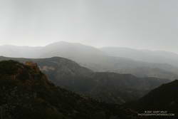
Another spectacular morning for a Southern California trail run.
The temperature on Saddle Peak was in the high-60s, with light winds out of the north.
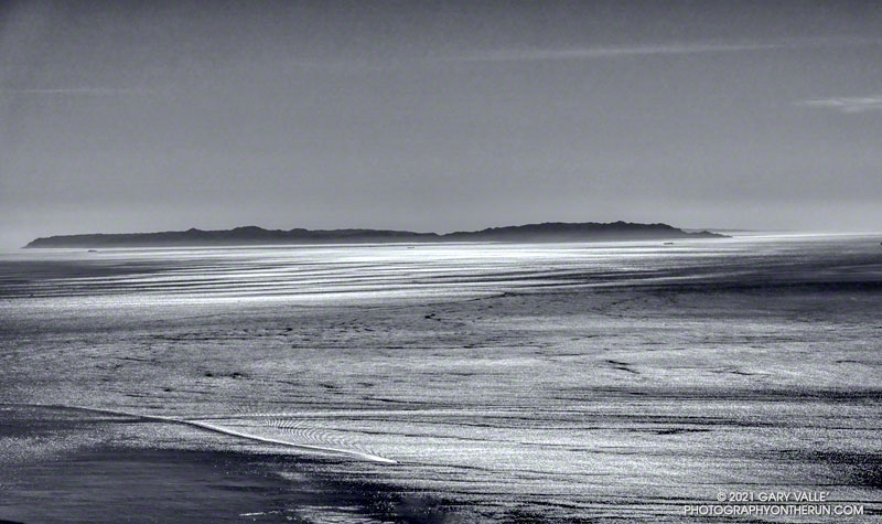
The distance to Two Harbors from Saddle Peak is about 45 miles.

Another spectacular morning for a Southern California trail run.
The temperature on Saddle Peak was in the high-60s, with light winds out of the north.
The distance to Two Harbors from Saddle Peak is about 45 miles.
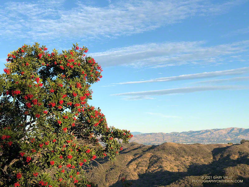
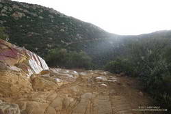
A week after doing the out and back run to the Ray Miller Trailhead, I was back in the Santa Monica Mountains and doing another popular trail run — the Trippet Ranch loop. Near the top of the Garapito Trail it dawned on me I’d seen no berries on the toyon shrubs and trees along the way. These red-orange berries usually add a bit of Holiday color to the chaparral, and at one time were so sought after that a law was passed to protect them.
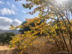
Toyon usually blooms in the Summer, producing green berries that slowly turn red-orange by the holidays. The title photo — of a toyon heavily loaded with berries — is from last Winter.
For the remainder of the run I checked most of the toyon along the trails back to the Top of Reseda. Not a single toyon had any berries.
How widespread was this? The following two weekends, I did runs in other areas of the Santa Monica Mountains. One was an extended version of the Bulldog Loop, and the other an out and back run from the Top of Reseda to the Oak Tree on Rogers Road segment of the Backbone Trail.
On those three runs I must have passed hundreds (thousands?) of toyon along the trail. Out of all of those I checked, only one had berries. It was near the water tank on Mesa Peak Mtwy fire road, at the top of the climb up from Tapia.
As you might expect, the most likely explanation for the lack of berries is the drought. Precipitation records for Downtown Los Angeles (USC) show that in 2019-2020, the rain season lasted about 5 months — from about mid November to mid April. Leading up to the flowering period for toyon the accumulated rainfall was a little above normal. The result was what you see in the title photo.
On the other hand, in 2020-2021, the rain season effectively began at the end of 2020 and ended in mid March. Less than half of normal rainfall was recorded going into the flowering period of toyon.
The toyon on Mesa Peak fire road that managed to produce some berries is situated near the crest of east-west oriented ridge. It probably benefits from enhanced precipitation because of its location.
Some related posts: Christmas Berry on the Garapito Loop, Best Trailhead to Start the Bulldog Loop, Will Rogers – Rivas Canyon – Temescal Canyon Trail Run
When I parked at the Wendy Drive trailhead, there was just enough light to see a wide band of high clouds overhead. That was good news. With a well-advertised storm expected to move through the area the next day, I hadn’t been sure what weather to expect for today’s run.
The general forecast was for low clouds and fog in the morning, giving way to partly cloudy skies in the afternoon. I was going to be running one of the more scenic trails in the Santa Monica Mountains — the Ray Miller Trail. High clouds and sunshine were a much better option than running in the fog or with gloomy, overcast skies.
Shortly after leaving the trailhead, the band of high clouds became underlit by the reds, oranges and yellows of the rising sun. It was going to be a good run.
The route-finding on this run is relatively straightforward. From the Wendy Drive trailhead on Potrero Road, run over to the Satwiwa Native American Indian Culture Center (see Satwiwa map). From the Culture Center run 4+ miles on Big Sycamore Canyon Road/Trail toward the beach. Some of this is paved.
Once past the junction of Sycamore Canyon and Wood Canyon fire roads, take either the Wood Canyon Vista Trail (Backbone Trail) or Fireline Trail up to the Overlook fire road. From the top of the Wood Canyon Vista Trail turn left on Overlook fire road, or from the top of Fireline turn right, and follow the road to the top of the Ray Miller Trail. The Fireline option is about 0.4 miles longer. Here’s a map from the State Park website. Note that the La Jolla Canyon Trail is closed.
The Ray Miller Trail drops about 1000′ over 2.6 scenic miles. There is usually water available at the parking lot at the trailhead. Today the conditions were about as good as they get. The trail was in excellent condition. The temperature was in the mid-70s. The marine layer was holding offshore and a few puffy clouds had formed over the higher peaks.
One of the things about the Ray Miller Trail is that run/hike up it is almost as enjoyable as the run down. It is a very popular, and there are almost always runners and hikers on the trail. Running up a section of trail, I thought I recognized someone going down. It was nine-time Badwater finisher Chris Frost. We talked for a while about trails, running and races.
From Overlook Fire road the route back to Wendy was a familiar one — Hell Hill, Wood Canyon Fire Road, Two Foxes Trail, Big Sycamore Canyon Road, Upper Sycamore Canyon Trail, Danielson Road, and the Satwiwa Loop Trail. Including a short jog over to PCH the run was a little over 24 miles with about 3100′ of elevation gain.
Here’s an interactive, 3D terrain view of the Wendy Drive – Ray Miller Out & Back trail run. The map can be zoomed, tilted, rotated, and panned. To change the view, use the control on the upper right side of the screen. Track and placename locations are approximate and subject to errors. Poor weather, and other conditions may make this route unsuitable for this activity.
Some related posts: A Windy Run, Walk, Ride, for Wildlife Research; Running to Ray Miller; Ray Miller Training Run
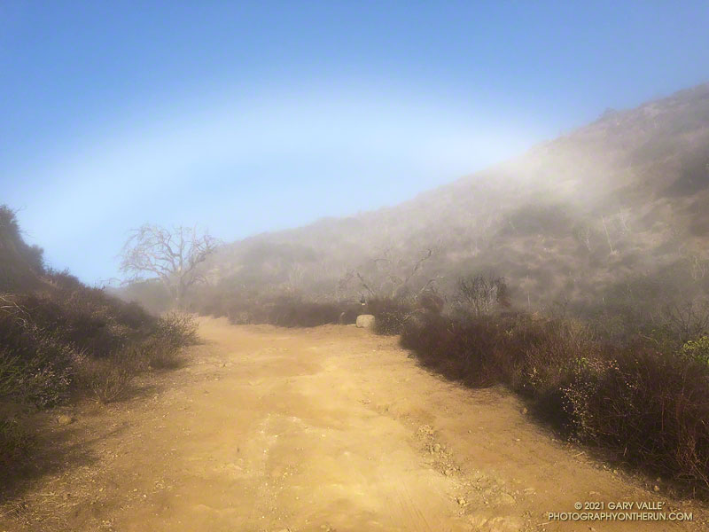
Fogbows form opposite the sun in a manner similar to rainbows, except the water droplets that create a fogbow are much smaller than raindrops. Because a fog droplet is so small, the physics of the interaction is different. The result is often a diffuse, primarily white bow.
The photograph of the fogbow was taken Sunday morning on an out and back run from Wendy Drive to Mugu Peak. The sun was about 14 degrees above the horizon. More about fogbows and other atmospheric phenomena can be found on Les Cowley’s Atmospheric Optics website.
Some related posts: Rainbow Colors in Cirrus Clouds Over Los Angeles, Out and Back Trail Run to Mugu Peak
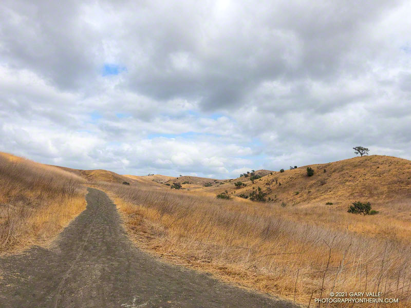
Hikers, riders, and runners reveled in the unseasonably cool afternoon temperatures at Ahmanson Ranch (Upper Las Virgenes Canyon Open Space Preserve) yesterday.
According to the NWS, the high temperature of 75 degrees at Woodland Hills (Pierce College) was the lowest for the date on record. The temperature at the Cheeseboro RAWS didn’t reach the 70s until around 1:30 p.m., and finally hit 75 around 4:30 p.m. Earlier in the day, the station recorded 0.03 inch of light rain.
I took advantage of the cooler weather to do an out and back trail run from the Victory Trailhead to Cheeseboro Canyon. The nine mile run has an elevation gain/loss of around 1000′. Except for a couple of hills, it’s a relatively fast-paced route, particularly on the way out to Las Virgenes Canyon. There are two creek crossings in Las Virgenes Canyon. These dried up earlier this year, but in some years the crossings have enough water to get your shoes wet.
It’s not a good run to do when it’s hot, and in the Summer Ahmanson is almost always hot. In-the-sun temperatures are typically above 100 degrees, and sometimes reach 110 degrees or more. More than once I’ve encountered people on Ahmanson area trails that misjudged the conditions and were out of water. And sadly, dogs are especially susceptible to heat.
Here’s an interactive, 3D terrain view of the run. The map can be zoomed, tilted, rotated, and panned. To change the view, use the control on the upper right side of the screen. Track and placename locations are approximate and subject to errors. Poor weather, and other conditions may make this route unsuitable for this activity.
Those that recreate at Ahmanson will recognize the title photo as East Las Virgenes Canyon, about 1.1 mile from the Victory Trailhead. This is where a trail/road to Lasky Mesa forks off the main road.
Some related posts: Run to the Cheeseboro Remote Automated Weather Station, Classic Cheeseboro Canyon, Big Southern Pacific Rattlesnake at Ahmanson Ranch
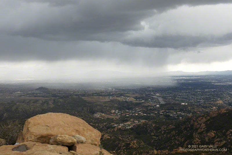
Was that thunder? I warily eyed the dark clouds over the mountains and pondered the situation.
I was about halfway to the top of the Chumash Trail and was planning to run along the crest to Rocky Peak. The run had started in short sleeves and sunshine, but it was pretty obvious that wasn’t going to last.
A cold upper-level low had brought badly needed rain to the area for the past two days. The low was moving off to the east, but there was still a chance of afternoon showers and maybe even a thunderstorm.
It was the “thunderstorm” part that I needed to pay attention to. I had enough gear to deal with a downpour and cooling temps, but electrical storms are no fun at all.
I decided to continue to the top of the Chumash Trail and reassess. As I worked up the trail, I pictured the counterclockwise circulation around the low, and how convective cells develop over the mountains and then dissipate as they drift south. The concern was that the cells don’t always dissipate.
It looked like things weren’t getting any better at the top of the Chumash Trail, but it wasn’t worse either. I hadn’t heard any thunder for a while, and most of the activity seemed to be a few miles to the west and east. Having been starved of stormy weather for much of the rain season, I turned right on Rocky Peak Road and headed south toward Rocky Peak.
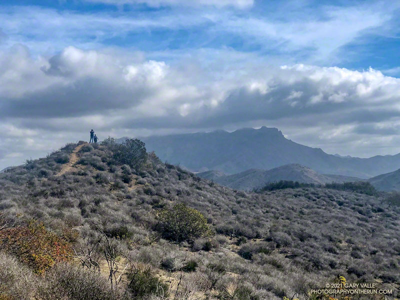
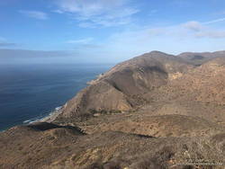
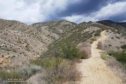
The run from the Chumash Trailhead to Rocky Peak is a challenging mix of technical single-track trail and hilly fire road. There are wide-ranging views of Simi Valley & Simi Hills, the San Fernando Valley, Santa Monica Mountains, Ventura County mountains, and San Gabriel Mountains. On a clear day, the view can extend to the Channel Islands, Saddleback, and San Jacinto Peak.
The actual turnaround point for a run to “Rocky Peak” varies. Some like to turnaround at the high point of Rocky Peak Road that is near Rocky Peak. Most of the time, I turnaround at a viewpoint that is at the end of a spur trail that branches off from the high point of Rocky Peak Road. From time to time, it’s fun to hike over to Rocky Peak and scramble to the top. That’s a bit more involved and requires some route-finding.
I felt the first raindrops as I reached the high point on Rocky Peak Road and turned onto the spur trail that leads to the overlook. There was some increased development to the east, but it looked like there would be enough time to get over to Rocky Peak, take a couple of pics, and then head back.
I felt a little exposed on top of Rocky Peak. I hadn’t heard any thunder for the past hour, but a cell to the east was spouting heavy rain over the San Fernando Valley, which meant there was probably enough development to produce lightning. I took the title photo and a couple of others and hurriedly descended from the peak.
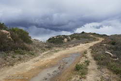
Back on Rock Peak Road, the sprinkles increased, and the showers became more steady as I ran north toward the Chumash Trail. Under the dark clouds, a raven perched on a large pinnacle cawed incessantly, either enjoying the rain or complaining about it. In the distance, a siren wailed down in the valley. It was cold, and I was very glad to have an extra shirt, sleeves, gloves and a light rain shell.
As I began the descent of the Chumash Trail, the sun briefly broke through the clouds, reflecting brightly on the wet sandstone rocks. I breathed deeply, relishing the smell of the cleansed air and wet chaparral, and continued down the trail.
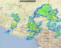
Here’s an interactive 3D terrain view of my GPS track. Over the run, the temperature sensor on my pack recorded a drop of about 30 degrees — from around 70°F at the start of the run to about 40°F when the showers began! Here’s what a NOAA Radar Mosaic looked like at the start of the run and when I was on Rocky Peak.
Related: Chumash Trail, Rocky Peak, Thunderstorm