Category Archives: adventures

Another Scorching Angeles National Forest/Mt. Disappointment Trail Race

Sunrise on Mt. Wilson prior to the start of the 2018 Angeles National Forest/Mt. Disappointment Trail Race

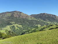
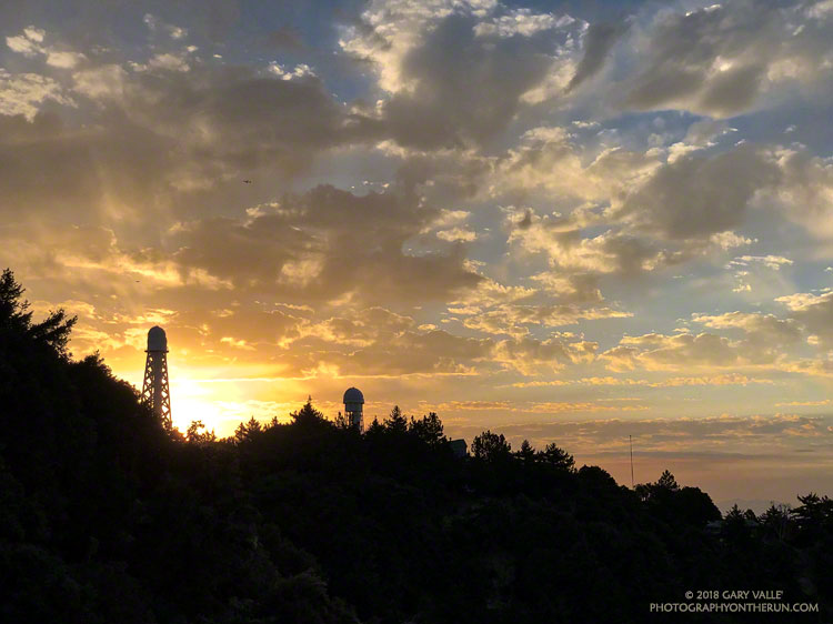
It was “déjà vu all over again” for the 12th running of the Angeles National Forest Trail Race on Saturday. When the sun rose over Mt. Wilson Saturday morning, the temperature was already in the 80s and monsoon clouds were scattered across the eastern sky. We all knew it was going to be a hot day. The only question was how hot?

Following weeks of seasonable — and often cool — weather, temps began to ramp up Thursday. On Friday many daily and some all-time record high temps were set around the Los Angeles area. Van Nuys set an all-time record high of 115°F. Downtown Los Angeles set a new daily record of 108°F and Woodland Hills set a new daily record of 117°F.

The high temperature recorded at Clear Creek for each of the ANFTR/Mt. Disappointment races. Click for a larger image.

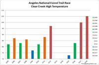
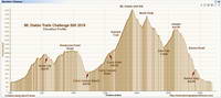
The record-breaking heatwave continued race day with temps on the ANFTR course surpassing the torrid temps of 2017. The Clear Creek RAWS recorded hourly temperatures as high as 100°F and hourly fuel temps as high as 123°F. The highest temperature measured at Clear Creek was 105°F — five degrees higher than last year’s race.

Once again, despite the heat, there were some AMAZING performances. In the 60K, first and second place in both the Mens and Womens division finished only a couple minutes apart. Mario Martinez’s 6:41:25 just edged Rupert Romero’s 6:43:27, and Katie Asmuth’s 7:29:11 was just ahead of Teresa Kaiser’s 7:32:21. Chase Coffey ran the 50K in 4:25:26, which I believe is the fastest time for the normal 50K course. (In 2009 we ran all the way to Red Box on Mt. Wilson road.) Ana Suchey was the top woman in the 50K with a time of 6:04:30. In the 25K Victor Martinez bested the record he set last year, running the course in 2:07:27. Jennifer Sunahara was first among the women, with a time of 2:58:29. Not all the great performances were from the fastest runners. Sa Il Hong, age 80, completed the 50K in fine form.

Many thanks to Gary and Pam Hilliard and all the ANFTR staff and volunteers! It wasn’t just hot for the runners! And those setting up the event and marking the course had to endure Friday’s record-setting temps, spend a warm night on the mountain, and then work in the heat again on Saturday!

See the ANFTR web site, Facebook page and Facebook group for more info. The Angeles National Forest Trail Race is the new name for the Mt. Disappointment Endurance Run. Only the name changed. All the results for the ANFTR/Mt. Disappointment races since 2005 can be found on Ultrasignup.com.

Note: The temperature in a commercial weather station is measured inside a white, ventilated instrument housing, several feet off the ground. Mid-day temperatures in the sun, in the summer, with a cloudless sky will be much warmer than this. Some stations, such as Clear Creek, also measure the fuel temperature — the temperature of a pine dowel in direct sun about a foot off the ground. According to the NWS (and common sense) exposure to full sunshine can increase heat index values by up to 15°F. In my experience the fuel temp gives a better indication of the actual temperature a runner can experience in the sun, especially on exposed mountain slopes facing the sun.

Related post: Record Heat for the 2017 Mt. Disappointment 50K & 25K

Still a Little Snow in Southern California

Snow patch at about 11,000' on San Gorgonio Mountain on June 9, 2018.

Given that Southern California has had way below average precipitation this rain year, I was a little surprised to find a few widely scattered patches of snow on San Gorgonio Mountain this past Saturday.

The patch of snow in the title photograph was at 11,000′, about a mile from San Gorgonio’s summit. This Google Earth image from last year shows an overview of the area. There was a lot more snow last year, but the same patch — in a deposition area — is near the “San Bern” in the “San Bernardino Peak Divide Trail” label.

There was “shorts and short sleeves” weather for the entire run from the South Fork trailhead.

Here are a few photos taken along the way.

Some related posts: San Gorgonio Mountain: Falls Creek Loop, August 2017; After the Lake Fire: The Dollar Lake – Dry Lake Loop on San Gorgonio Mountain

A Roundabout Route to Mt. Baden-Powell

Mt. Islip and South Fork Canyon in the San Gabriel Mountains

Given the choice of doing an out and a back run, or a loop, most of the time I’ll pick the loop. Loops encompass more terrain, incorporate more trails, offer more varied scenery, are more adventurous, and normally put you back where you started.

There are many excellent loops in the San Gabriel Mountains. Last week’s loop from Three Points around Mt. Waterman is a run I like to do a few times a year. Today’s run is another favorite — the Islip Saddle – South Fork – Mt. Baden-Powell loop.

This loop combines a demanding descent to the desert on the South Fork Trail with an arduous 5000′ ascent of Mt. Baden-Powell. From Baden-Powell the PCT is followed along the crest back to Islip Saddle. More info can be found in the related posts linked below.

Here are a few photos taken along the way.

Some related posts: South Fork Adventure, Wally Waldron Limber Pine, San Gabriel Mountains Running Adventure

Cool Weather, Old Trees, Grape Soda Lupine and a Restored Trail

Section of Three Points - Mt. Waterman Trail cleared of trees killed in the 2009 Station Fire.

The weather was surprisingly cool for a Memorial Day weekend in the San Gabriel Mountains. At Three Points (5925′) the temperature was a brisk 43°F when I started my run, and it remained in the 40s as I worked up the Three Points – Mt. Waterman Trail toward Twin Peaks and Mt. Waterman. The trail from Three Points is a long-time favorite and part of an adventurous — and scenic — 20 mile loop around Waterman Mountain.

In 2009 the Station Fire ran up the ribs and gullies of the south face of Mt. Waterman, ravaging some slopes, but leaving others untouched. Many trees were killed, including some old growth incense cedars and Jeffrey pines. On a run in March 2017 I counted more than 40 dead trees down on the trail. At that time a few trees had already been cleared from the trail and in the following months many more would be.

Grape soda lupine along the PCT in Cooper Canyon.
Grape soda lupine along the PCT in Cooper Canyon. Click for larger image.

One particularly hard hit area is about a half-mile west of the Twin Peaks Trail junction. Last Summer dead trees blocked the trail in this area and in places were stacked one on top of another. The title photo is of the same area after the trail was cleared.

On a previous run I’d photographed the growth rings of a burned Jeffrey pine above the Twin Peaks Trail junction and estimated the total at about 325. Today, a recently cut Jeffrey pine just west of the Twin Peaks Trail looked like it might be considerably older. A very rough count of its rings totaled 475.

On this run the Three Points – Mt. Waterman Trail was almost entirely clear of trees and in the best condition I’ve seen since the Station Fire. Many thanks to Alan and the SoCal Hikers & Trail Builders for restoring this trail!

Here are a few photos from the run.

Some related posts: Downed Trees, Melting Snow, and a Waterfall; Three Points Loop Plus Mt. Waterman; After the Station Fire: Pine Seedling Along the Mt. Waterman Trail

Diablo Trails Challenge 50K 2018

North Peak from the North Peak Trail. Mount Diablo Trails Challenge 50K.

Just 48 hours before the start of the Diablo Trails Challenge the temperature on Mt. Diablo’s summit was a chilly 31°F. Gray, wind-driven clouds shrouded the summit, propelled by 20-30 mph winds. Over the 10 days preceding the race, it had rained on four, and Concord had received about two inches of rain.

That’s the thing about Spring weather – a couple of days can make a huge difference. Today – race day – the sun is out, the hills are green and skies blue. Very little mud remains – the trails are in great shape and hills sprinkled with wildflowers. It’s the perfect day for a run on Mt. Diablo!

Diablo Trails Challenge 50K Elevation Profile

With around 7000′ of elevation gain/loss, the Diablo Trails Challenge 50K is characterized by its many ups and downs. The core of the 50K course is the 7 mile, 3000′ climb from the Curry Canyon Ranch aid station to Diablo’s main summit. But before you can enjoy this fine ascent, you have to get to Curry Canyon Ranch. And it’s on the other side of the mountain – about 12.5 miles away. Here’s a 3D interactive view of my GPS track of the 50K course.

Along the way there are several get-your-feet-wet creek crossings and many hills. Following along on the map, the course works its way past Wall Point, Artist Point, Knob Point and finally Windy Point. Did I mention the course is hilly?

Somewhere around Mile 10 you get the first good view of Mt. Diablo and North Peak. The runner in front of me exclaimed, “Holy guacamole, is that what we are going to climb?” My choice of words were similar, but not quite as polite. Yes indeed, those were the peaks, and they loomed LARGE across the valley.

Mount Diablo and North Peak from Knobcone Pine Road.
Mt. Diablo (left) and North Peak

Elevation gained is so easily lost. After gaining about 2500′ on the way to Windy Point, a 1000′ descent leads to the Curry Canyon Ranch Aid Station. The climb of Diablo starts here, but you really don’t feel like you’re on the mountain until you reach South Gate Road and the Curry Point Aid Station, about three miles up the canyon. The grade in Curry Canyon is moderate and I tried to take advantage of that, knowing steeper terrain was ahead.

The Half-Marathoners joined the course at Curry Point — adding their enthusiasm and company – but they were soon headed back down, leaving us to cope with the Summit Trail all on our own.

“Jalapeño chip?,” I asked the runner hiking up the hill next to me. He smiled and said something like, “Maybe next time.” I did what I could to keep from constantly looking up at the summit. I munched on chips, talked to runners and hikers, read the “Trail Through Time” interpretive signs, looked at wildflowers and enjoyed the great views. As long as you keep putting one foot ahead of the other — and maybe smile from time to time – summits will eventually arrive.

Yahoo! The Summit Aid Station! There is almost no wind. In the sun it’s comfortably warm and in the shade comfortably cool. As at the other aid stations, the volunteers are great, helping me to get my hydration pack sorted and get me on my way. After seven miles of uphill, a little downhill is going to feel really good.

North Peak Trail near Devil's Pulpit.
North Peak Trail near Devil’s Pulpit.

The next few miles I’d done before and they are among the most interesting on the course. It helped to be familiar it – especially the notoriously steep section of North Peak Road, just before the summit. Everyone picks a different route. This time I stayed on the left going up and the right going down, and didn’t fall on my butt!

Once past the “slide” it didn’t take long to get down to Prospector’s Gap. I recalled that the running on the Bald Ridge Trail was excellent and wasn’t disappointed. At Meridian Ridge Road we left Bald Ridge and descended into Mitchell Canyon. At Deer Flat Creek, once again the course headed up. I couldn’t recall how long the climb was going to be, but it looked like we were going to have to work over a high ridge to get to the Castle Rock side of the mountain. The ridge turned out to be Moses Rock Ridge and the climb over it fit right in with the other hills on the course. Click, click goes the elevation-gained counter.

Most of the course is a big loop, but to access the peaks and aid stations there are four short out and back sections. You get to know the runners around you on these sections and we’d give each other encouragement as we passed. The runners around me were great and throughout the run we had many good conversations.

Then there was Burma Road. Somewhere around mile 26, I commented to another runner that we were running out of miles and at some point we were going to have to lose a lot of elevation. The Burma Road descent took care of that.

Many thanks to Jasmin and Sam of Brazen Racing for putting together such a superb event! And a BIG thank you to all the volunteers, ham operators, runners, park staff, sponsors and especially the Save Mount Diablo Foundation. I thoroughly enjoyed running on Mt. Diablo!

Here are a few photos taken along the way. More photos and all the results are available on the Brazen Racing web site.

Spring on the Bent Arrow Trail

Encelia Along the Bent Arrow Trail

I usually do the 21 mile Will Rogers – Temescal loop once or twice a year, and that’s just long enough to forget the difficulty of the strenuous climbs, and remember the outstanding downhill on the Backbone trail, great views of the city, and lush growth in Temescal Canyon.

If the day is warm the return from the coast can be particularly brutal. Today it was cloudy and cool for much of the run, and it wasn’t until the final mile on the Bent Arrow Trail that the sun broke through.