Front Range Duo: San Gabriel Peak and Strawberry Peak

Bigcone Douglas-fir on San Gabriel Peak

The two highest peaks in the front range of the San Gabriels, Strawberry Peak (6164′) and San Gabriel Peak (6161′) are about three miles apart as the raven flies and about 6 miles apart by trail. If you don’t mind running/hiking a third of a mile on Mt. Wilson Road, you can do both of them from Red Box as a 12 mile run/hike with a total gain of about 3000′.

Strawberry Peak and Mt. Lawlor from San Gabriel Peak.

Earlier this morning, I’d done San Gabriel Peak. It’s the shorter of the two ascents — from Red Box it’s about 2.4 miles to the summit. While the elevation gain is nearly the same as climbing Strawberry, it is a less strenuous and more straightforward peak. Except for a short stint on the service road below Mt. Disappointment, the grade of the San Gabriel Peak Trail is relatively constant — and the trail goes all the way to the summit.

Josephine Peak (5558') and Mt. Lukens (5074') from the summit of Strawberry Peak.
Josephine Peak and Mt. Lukens from the summit of Strawberry Peak.

The route up Strawberry Peak is distinctly different. The initial 2.5 miles follows the Strawberry Peak Trail to Lawlor Saddle, gaining a moderate 500′ along the way. From there a steep, rough and sometimes rocky use trail ascends 950′ in a little over a mile to Strawberry’s summit.

That’s where I was now — nearly at the end of that brutal mile-long climb. My heart was racing and my legs felt like Jello. Reaching the crest of Strawberry’s final false summit, I jogged across the shoulder of the peak and on uncooperative legs climbed the final few feet to the summit.

To the southeast, San Gabriel Peak and Mt. Disappointment stood across the canyon and further to the east, indistinct in the morning haze was snow-capped Mt. Baldy. To the west, the view extended past Josephine Peak and Mt. Lukins to the San Fernando Valley, Santa Monica Mountains and Santa Susana Mountains.

The southwest side of San Gabriel Peak was burned in the 2009 Station Fire.

Recovery from the devastating 2009 Station Fire continues on both peaks. The amount, extent and size of Poodle-dog bush (Eriodictyon parryi) in the burn area is slowly diminishing. Some plants have died, but there are still viable plants of which to be wary. These plants were on the San Gabriel Peak Trail, above the notch, on the final climb to the summit of the peak. I don’t recall seeing any Poodle-dog bush on the ascent of Strawberry from Red Box, but it is still present on the west side of the peak.

Some related posts: Strawberry Peak, Switzer’s and the Old Colby Trail, Bear Canyon Loop Plus Strawberry Peak, After the Station Fire: Ten Miles – Four Peaks

Bigcone ENSO Prediction, Poodle-dog Bush Blues, and a Surprise on Kenyon Devore

Morning sun on the dome of the Mt. Wilson Observatory

I’d paused to rinse my arms and legs, hoping to wash away at least a little of the poison oak and Poodle-dog bush I’d been unable to avoid. I was at a small spring part way up the Kenyon Devore Trail, doing a variation of a loop that my son and I had done a year before.

Today’s run had started on the top of Mt. Wilson, descended the Rim Trail to Newcomb Pass then followed the Gabrielino Trail down to the Rincon – Red Box Road. This year instead of taking the forest road down to West Fork, I stayed on the Gabrielino Trail and descended to Devore Camp, and then worked back upstream on the Gabrielino Trail past West Fork to the Kenyon Devore Trail.


Driving up the Mt. Wilson Road I’d noticed that many of the bigcone Douglas-firs were heavily laden with cones. According to the Forest Service’s Silvics Manual bigcone Douglas-firs don’t often have bumper crops. Why now, following two subpar rain seasons, the most recent of which was unusually dry? Was the tree’s evolutionary knowledge playing the odds that a wet period of Southern California’s wet/dry ENSO cycle is a Winter or two away? At the moment La Nina or Neutral conditions look more likely this coming Winter, but the odds for El Nino could increase for the Winter of 2014-15.

Update June 25, 2018. El Nino conditions did emerge in late Fall 2014 and continued until the Spring of 2016. However, the drought in Southern California persisted and below average precipitation was recorded in both 2014-15 and 2015-16. It wasn’t until the 2016-17 rain season (during a weak La Nina) that Southern California received above average precipitation.


Like last year there was plenty of poison oak and Poodle-dog bush along the Rim and Gabrielino Trails. The poison oak was about the same as last year — mostly but not entirely avoidable — but the Poodle-dog seemed worse. I’d hoped that this year’s much lower than average rainfall would suppress the growth of Poodle-dog bush, but if anything it seemed more robust. Poodle-dog had overgrown the trail in several spots, its long stalks and sticky leaves overlapping the trail like a gauntlet of pikes. Contact was unavoidable.


It had been interesting to visit Devore Camp. The last time I’d been there was in March 2003 when Gary Gunder and I paddled from the West Fork San Gabriel River from West Fork to Hwy 39. We had been fortunate to be able to paddle the reach with few portages. With all the downed trees from the Station Fire it may be many years before big storms flush the river channel to point it can be paddled without logs being a constant problem.


In addition to the expanses of Poodle-dog bush blossoms, a number of other wildflowers were in bloom, including Grinnell’s beardtongue, rose snapdragon, blackberry, pink, paintbrush, bush poppy, buckwheat, gilia, Keckiella and others. Along the West Fork the blossoms of spotted Humboldt’s lilies had beamed like yellow-orange paper lanterns scattered throughout an immense garden.

I cannot ascend the Kenyon Devore Trail without thinking about the Mt. Disappointment 50K/50M. During those races the little spring I was at now had always been a welcome source of “extra” water on the final climb to Mt. Wilson. The 2013 races have been cancelled, but are expected to return in 2014. We all know how tough R.D. Gary Hilliard is and look forward to next year’s race!

“Hey, are you on a trail?”

The voice seemed to come from nowhere. I looked to my left and right, but the trail was empty.

“Hey, up here!”


What the… I scanned the STEEP slopes above the creek, but still had a hard time locating the voice. After a moment of rustling, a helmeted figure emerged from the trees, carrying an orange mountain bike.

If you’ve done the Kenyon Devore Trail as part of the Mt. Disappointment races or at another time you probably recall the slippery stream crossing with the chain. The MTBer had apparently missed a switchback about a mile up the trail and descended directly down a ridge to the spring.

Update Friday, June 21, 2013. Lucked out with the Poodle-dog bush* and poison oak! Just one small spot of irritation on the top of an ankle, and it’s already almost gone.

*The taxonomic name for Turricula parryi (Poodle-dog bush) has changed to Eriodictyon parryi. The Jepson Manual: Vascular Plants of California, Second Edition (2012) has returned Turricula to the genus Eriodictyon, as originally described by Gray. According to the Wikipedia entry for Turricula (April 11, 2012), “… molecular phylogenetic analysis carried out by Ferguson (1998) confirms that Turricula should be treated as a separate genus within a clade (Ferguson does not use the term “subfamily”) that includes Eriodictyon, and also the genera Nama and Wigandia; Eriodictyon is the genus to which Turricula is closest in molecular terms, and is its sister taxon.” I use “Turricula” and “Poodle-dog bush” interchangeably as a common name.

Some related posts: Mt. Wilson Rim Trail – Kenyon Devore Trail Loop, GSU Mt. Wilson CHARA Telescope Array, Why Won’t My Smart Key Work?

After the Station Fire: Why is Strawberry Peak Still Closed?

Update May 29, 2014. According to an Angeles National Forest press release issued May 20, nearly all remaining areas in the Angeles National Forest closed since the 2009 Station Fire were reopened on May 24. Some forest areas remain closed for reasons of public safety or further work needed on trails. In addition to the Colby Trail in the area of Strawberry Peak, the closed areas include Lower Gabrielino Trail (below Bear Canyon Trail), Barley Flats Trail, Ken Burton Trail, Millard Water Fall User Trail, Santa Clara Divide Road (FS3N17), Messenger Flats Campground, Lightning Point Campground, and Big Buck Campground. Check with the Forest Service for the most current information.

Update May 31, 2013. On May 24th Angeles National Forest quietly extended the closure of the 46,194 acre Station Fire Recovery Area through May 24, 2014. No press release or information regarding the rationale for the continued closure was published on the Angeles National Forest web site. A fire closure of this duration and acreage appears to be unprecedented in California and possibly the U.S. Even in the case of the largest California fires, the Cedar and Zaca fires, closed areas in Cleveland and Los Padres National Forests were reopened within a year of the fire. In many cases fire closures in the National Forests and State Parks of California have been lifted within days or weeks of a large fire. This reflects a general policy that closures of public lands should be implemented and maintained only as a last resort.

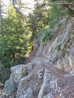
Update April 16, 2013. Strawberry and Josephine Peaks have now been closed over THREE AND A HALF YEARS. Will Angeles National Forest allow the Station Fire Recovery Area Closure Order to expire on May 24, 2013? Note that none of the trails to the summit of Strawberry Peak are maintained. They are “use” trails — paths that have evolved over time through use. The route to Strawberry’s summit from Red Box is use trail from Lawlor Saddle to the summit; and the routes that ascend the west ridge are use trail above Josephine Saddle. The west ridge also includes some third class rock climbing. It should also be noted there were rescues and other incidents on Strawberry Peak (and in other Forest areas) BEFORE the Station Fire and there will continue to be rescues and incidents. Whether a trail is a good trail or bad trail, accidents can occur and mistakes in judgment can be made. The Forest Service should not keep an area closed without definitive — and supportable — reasons for doing so.

Update May 25, 2012. Today Angeles National Forest reopened about 41,000 acres of the Station Fire closure area south and west of Big Tujunga Dam, and extended the closure of the remaining 46,194 acres to May 24, 2013. Newly opened resources include the Stone Canyon Trail, Trail Canyon Trail, and Delta Flat. Condor Peak also appears to be within the open area. According to the updated Forest Service map of the Station Fire Recovery Area (PDF), Strawberry Peak and Josephine Peak are in the area that remains closed.

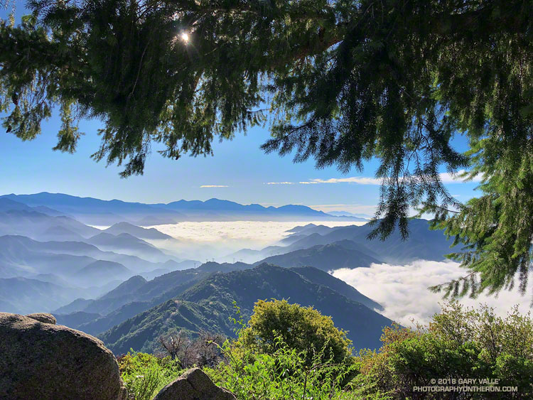
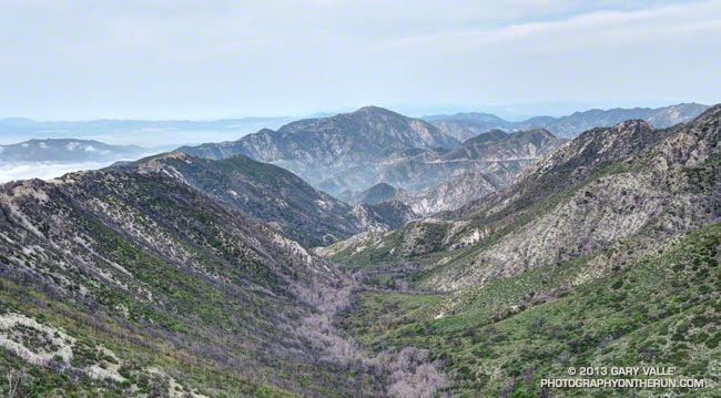
As a result of its relatively easy access, panoramic summit view, varied routes and generally mild Winter conditions Strawberry Peak is one of the most frequented summits in the San Gabriel Mountains. At least it used to be until it was closed by the Station Fire. Here we are, more than two and a half years after the Station Fire, and Strawberry Peak, Josephine Peak and Mt. Lawlor are still closed.

Why? The reason might be as arcane as it was simply easier to define the closure boundary as Angeles Crest Highway.

It cannot legitimately be claimed that the area was more damaged by the fire. If anything the damage done by the fire and subsequent flash floods and debris flows was greater on the open (south) side of Angeles Crest Highway — between Switzer Picnic Area and Red Box — rather than on Strawberry Peak.

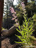
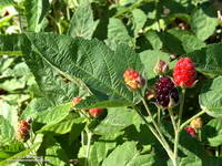
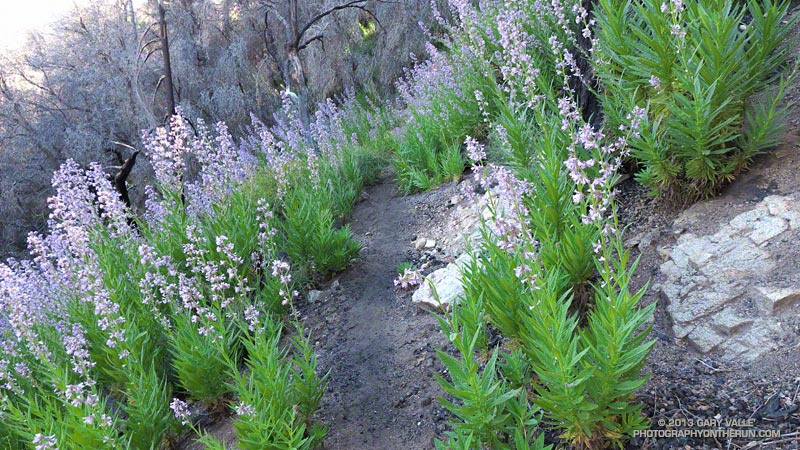
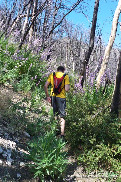
It cannot be the progress of recovery. I’ve closely followed the recovery of chaparral following several fires. The photographs and other evidence I’ve seen suggest the chaparral on Strawberry Peak is recovering at an absolutely normal pace. I think many would be surprised to see how far it has come. In fact its regrowth now threatens long established paths and trails.

I was under the impression that the route up Strawberry from Red Box was so overgrown and damaged as to be nearly impassable. Apparently that’s not the case. People are doing the peak and based on the reports I’ve read, photos I’ve seen, and firsthand information relayed the trail is in poor condition, but passable with care. There are certainly more hazardous trails and areas in the open areas of Angeles National Forest.

That route from Clear Creek also appears to be passable with care. I’m told there’s absolutely no issue on Josephine fire road. The use trail on the western ridge is a little overgrown, but can generally be followed. Apparently a short section of the ridge below the class 3 section is a bit overgrown with Turricula (Poodle dog bush). A little more use and snip here and a snip there would take care of that.

Restricted use is an important concern. Having seen the condition of several trails immediately after portions of the Station Fire area reopened, and then a year later, it’s clear to me that use is an essential element of trail health. People using a trail help keep it alive. Conscientious  users will pick up litter, remove debris, and do other on-the-go trail maintenance. Use quickly puts the focus on problem areas, and encourages participation when more comprehensive trailwork is done.

With the regrowth of the chaparral well underway we are at a critical point in the preservation of the trails and paths in the Station Fire closure area. They must be reopened to use — not only on Strawberry Peak, but also on popular peaks such as Condor Peak and Mt. Lukins. If we are not allowed to use the trails, the time and work required to restore them could increase to the point that some trails are lost!

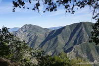
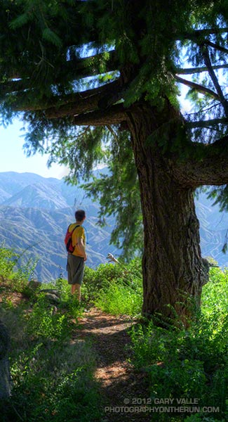
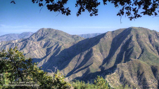
The photograph of Strawberry Peak (left) and Mt. Lawlor is from a trail run in September 2011. 

Some related posts: Blue Skies and Short Sleeves on Strawberry Peak, Coincidence, Strawberry Peak Traverse

Unwinding from the Backbone Ultra

Bear Canyon
Bear Canyon

Doing a moderate run in the San Gabriels and climbing a few peaks was a great way to unwind from the excitement of doing the 68 mile Backbone Ultra last weekend.

I felt good. I’d run more or less normally in the week following the event — depleted, but without any physical issues. In part that can be attributed to how Coyote Cohorts runs their events. It was basically a long training run in the company of a great bunch of runners and the help of incredible volunteers. Amazing! The long hours of training also really helped, particularly the back-to-back runs following 50Ks and the back-to-back night/day training runs. My shoes — Hoka Mafate 2s — also helped, reducing the impact of all the miles.

Paintbrush on the San Gabriel Peak Trail near Markham Saddle.
Paintbrush on the San Gabriel Peak Trail

One of the reasons for doing today’s run was to check how Poodle-dog Bush and some other plants are faring in this low rainfall water year. Since July 1 Downtown Los Angeles has recorded only 5.14 inches of rain. Unless we can manage to wring about a half-inch of rain from the heavens before June 30, this water year will go down as the fourth driest since record-keeping began in 1877. The driest water year on record was in 2005-2006 (3.21 inches). Assuming we don’t get that 0.48 inch of rain, three of the four driest water years have occurred since 2000.

Something I noticed on the Backbone run and recent training runs in the Santa Monica Mountains is that plant growth and flowering has been surprisingly robust given the amount of rainfall. This was also the case today on today’s run — the manzanita on the San Gabriel Peak Trail was covered in blossoms and bees, and the nightshade and paintbrush along the trail also seemed to be doing well.

Prickly phlox along Calabasas Peak Mtwy.

What about the Poodle-dog bush, aka Turricula? It looked about the same as last year at this time — just starting to come out of Winter dormancy. Last year we had above average rainfall in April and it really seemed to spur the growth of Poodle-dog bush. This year maybe we’ll see what an extended period of dry weather does to it. Last year some of the Poodle-dog died before the rain in April.

Here’s a short slideshow of a few photos from today’s run in the San Gabriel Mountains, as well as some photos of plants and flowers on recent runs in the Santa Monica Mountains.

Mt. Wilson Rim Trail – Kenyon Devore Trail Loop

Big cone Douglas-fir on the Rim Trail near Mt. Wilson

Brett was down for Father’s Day weekend and one of the things we wanted to do was get in a couple of good trail runs. He’s heard me talk (a lot) about the Mt. Disappointment 50K and how it ends. Basically you run 27 hilly miles with over 3600′ of elevation gain, THEN finish the race by doing a 5 mile, 2650′ climb from West Fork up the Gabrielino & Kenyon Devore Trails to the top of Mt. Wilson.

This final climb tells the 50K tale. If you’ve trained well and run a good race a middle-of-the-pack runner might gain 15-20 minutes on this leg. If not, you could easily lose an hour or more. In any case you put everything you have left into this climb. An elevation profile and some stats for Kenyon Devore are included in the post Hitting the (Big) Hills of Southern California.

There are several ways to incorporate Kenyon Devore into a loop, but I could only think of two that didn’t involve running on Mt. Wilson Road. One option was a 22 mile/5000’gain loop from Shortcut Saddle to Mt. Wilson and back. That wasn’t going to happen because just five days before I’d run the Holcomb Valley 33 Mile race. Instead we opted to start on top of Mt. Wilson and use the Rim Trail, Gabrielino Trail and Rincon – Red Box Road to get to West Fork. This would pare down the loop to a manageable 12 miles and 3000′ of gain.


Other than a “few” gnats, a lot of poison oak and some Turricula (Poodle-dog bush), the Rim Trail was in good shape and the running excellent. Once away from the observatory complex the trail has an adventurous, backcounty feel. The trail was in good enough condition that Brett enjoyed running it in the KomodoSport LS.

The day was going to be a scorcher and I was glad that much of the Rim Trail was on the shaded, north side of the crest. The Gabrielino Trail and Rincon – Red Box Road were also relatively cool and in the shade. With no race clock ticking away, we stopped at West Fork and ate some blueberries and PB&J. So far the route had been down, down, down; but in a few minutes it was going to go up, up, up.


One of the surprises of the day was how much the Turricula (Poodle-dog bush) had grown along the Gabrielino and lower Kenyon Devore Trails since I had been here in early March. A rain gauge near here (Opids Camp) recorded nearly seven inches of precipitation from March 25 to April 26. This appears to have promoted the growth of the Turricula. In a very dry rain season the rain and snow had been much needed. It rejuvenated the streams and vegetation, and the area looked much as it would if the seasonal rainfall had been normal.

The Turricula could not be avoided in some places, but that will be remedied in a couple of weeks when Gary Hilliard’s Mt. Disappointment Endurance Run volunteer trailwork group works on this section of the Gabrielino Trail and the Kenyon Devore Trail.

Update June 21, 2012. Although my contact with Turricula on this run was very limited, I did have a mild reaction, mainly on my arms. There was very slight inflammation and the “prickly” itching that is characteristic of Turricula. The itching became noticeable about a day after exposure and persisted for 4-5 days. Although mild, the reaction was stronger than occurred following several similar encounters last year. One difference was the exposure to poison oak on the Rim Trail earlier in the run. It’s possible that there was a cross reaction. This was observed in animal testing, but not in (limited) human tests. However, my reaction following this latest encounter was much, much milder than my first bout of Turricula, which resulted from wading through large patches of the young Poodle-dog plants on miles of overgrown trail. That first very strong response may have also involved a cross reaction with poison oak.


With the Summer Solstice approaching and the Sun so high, the temperature difference between sunny and shaded sections of trail was remarkable. About the time we were on Kenyon Devore the Clear Creek RAWS recorded a fuel temperature — the temperature of a wood dowel in direct sun — at a scorching 104°F. Brett did well on the climb and could have zoomed ahead. I had not recovered from Holcomb and struggled a bit on the exposed and steep sections of trail. Higher on the trail there was a breeze and more shade and that helped. It also helped pouring water over my head at the creek crossing!

It was great to show Brett Kenyon Devore, and what better way to sharpen the appetite for one of his superbly prepared dinners!


Humboldt Lily


Turricula (Poodle-dog Bush)


California Sister

California Bluebells Along the Gabrielino Trail

California bluebell (Phacelia minor)

Like Turricula (Poodle-dog bush)*, California bluebell (Phacelia minor) has been shown to cause a contact dermatitis similar to poison oak. The results from one study suggest the “dermatotoxic potential” of California bluebell approaches that of poison ivy/oak and that it is more likely to produce a reaction than Turricula.

Fortunately California bluebell doesn’t appear to be as prolific a fire follower as Turricula and is a much smaller plant.

The photograph is from a trail run in May.

*The taxonomic name for Turricula parryi (Poodle-dog bush) has changed to Eriodictyon parryi. The Jepson Manual: Vascular Plants of California, Second Edition (2012) has returned Turricula to the genus Eriodictyon, as originally described by Gray. According to the Wikipedia entry for Turricula (April 11, 2012), “… molecular phylogenetic analysis carried out by Ferguson (1998) confirms that Turricula should be treated as a separate genus within a clade (Ferguson does not use the term “subfamily”) that includes Eriodictyon, and also the genera Nama and Wigandia; Eriodictyon is the genus to which Turricula is closest in molecular terms, and is its sister taxon.” I use “Turricula” and “Poodle-dog bush” interchangeably as a common name.

Related post: Contact Dermatitis from Turricula parryi – Poodle-dog Bush and these additional posts.