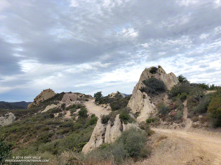
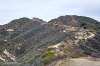
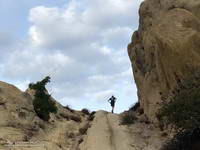
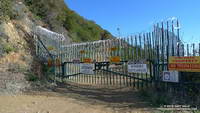
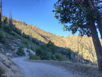
On June 1, Angeles National Forest reduced the size of the Bobcat Fire Closure, opening up most of the upper West Fork San Gabriel River area. Curious to see how the West Fork area is recovering from the Bobcat Fire, today I ran a slightly shortened version of the ANFTR/Mt. Disappointment 25K course.
Since the Mt. Wilson parking lot is usually closed until mid-morning, this morning’s run started and ended at a small turnout near the top of the Kenyon Devore Trail on the loop road on Mt. Wilson. The ANFTR Trail Races start at the main Mt. Wilson parking lot.
I’d recently done the San Gabriel Peak and Bill Riley Trails and knew they were in reasonable condition. And I’d read that AC100 Trail Work Teams led by Gary Hilliard and Ken Hamada had cleared the Gabrielino and Kenyon Devore Trails earlier this year. So, I didn’t expect to have a repeat of the epic fallen-tree obstacle course that I experienced doing this course in 2020.
First published on June 30, 2015. Updated June 8, 2023.
June 15, 2023. According to the AC100 website the 2023 Angeles Crest 100 Mile Run has been cancelled. According to R.D. Ken Hamada, CalTrans engineers do not expect Highway 2 to open until this Winter, at the earliest. The section from Islip Saddle to Grassy Hollow could be closed even longer.
July 29th will mark the 34th time runners from near and far gather in a small parking lot in Wrightwood, California, to start the Angeles Crest 100 Mile Endurance Run (AC100). Begun in 1986, the AC100 is one of the original five 100-mile U.S. endurance races. It has endured fires, floods, the Covid-19 pandemic, and changing trail restrictions.
There’s a tradition of running grueling endurance races in the San Gabriel Mountains. The Big Pines Trail Marathon was one of the first organized mountain ultramarathons in the U.S. First run in August 1934, its course used some of the same trails that AC100 runners enjoy today.
The AC100 is not like a road marathon. It is an entirely different kind of running event and an entirely different kind of running experience. In 2023 the L.A. Marathon had about 22,000 participants. About 1/100th of that number — around 250 runners — are expected to start the AC100.
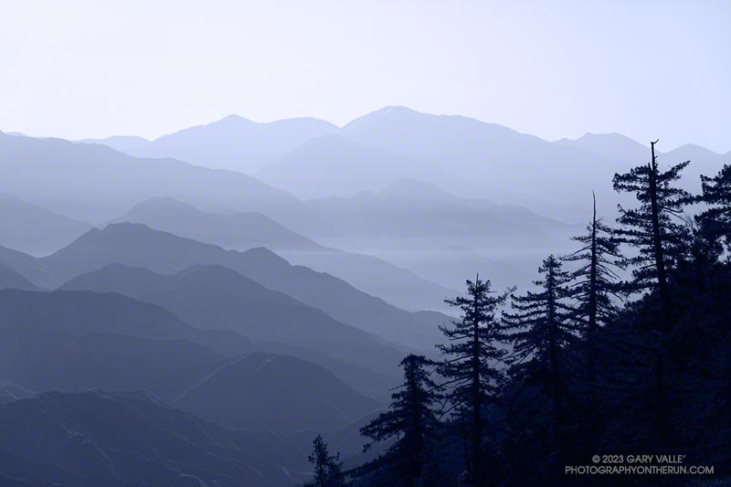
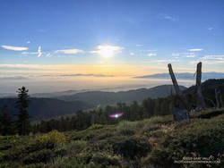
Sunrise from Blue Ridge during the 2015 AC100.
For many, one of the primary reasons for running the AC100 is to be fully immersed in the beauty and majesty of the San Gabriel Mountains. Runners start at 5:00 a.m., ascend the Acorn Trail, and as the sun rises, find themselves above 8000′, reveling in the spectacular views from Blue Ridge.
Even at this early stage of the race, the field is already becoming dispersed. By the time runners reach the first checkpoint, nine miles into the run, there is an hour spread between the first and last runners. Unlike a road marathon, much of the time a runner in the AC100 will be alone.
This year’s course returns to a point-to-point format, ending in Altadena. Because of damage to the Chantry Flat area by the Bobcat Fire, runners will bypass Chantry and ascend Mt. Wilson via the Kenyon-Devore Trail, returning to the traditional course at the Mt. Wilson Toll Road above Idlehour.
As a result of this Winter’s frequent storms, many trails have been damaged or blocked by trees and debris. Ultrarunners not only spend many hours enjoying the trails in our local mountains but also do hours of trailwork that helps keep trails open and in usable condition.
Once again this year, some long stretches of the AC100 course will be run on Angeles Crest Highway. As was done for the Western State 100 Mile course, AC100 organizers have been trying to obtain an exception to use trails historically included in the event. You can help get runners off the highway and back on the trail — for more information, see the Save the AC100 page on the AC100 website.
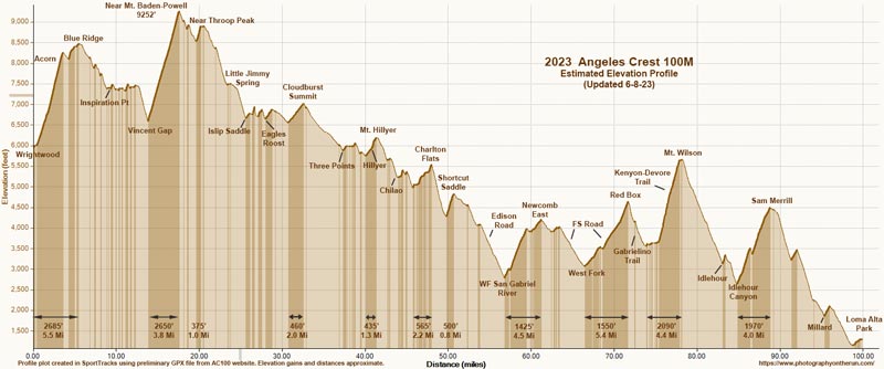
The elevation profile for the 2023 AC100 course (PDF) was created in SportTracks from the GPX file on the AC100 website on 6/8/23. The elevation profile was corrected using 3DEP 1-meter Lidar-based DEMs. A conservative elevation data smoothing setting was used, resulting in an estimated cumulative gain of about 17,890′ and loss of 22,550′. The actual gain and loss are probably a bit more. Placemark locations, mileages, and elevation gains and losses are approximate.
Click to view/download PDF of the elevation profile.
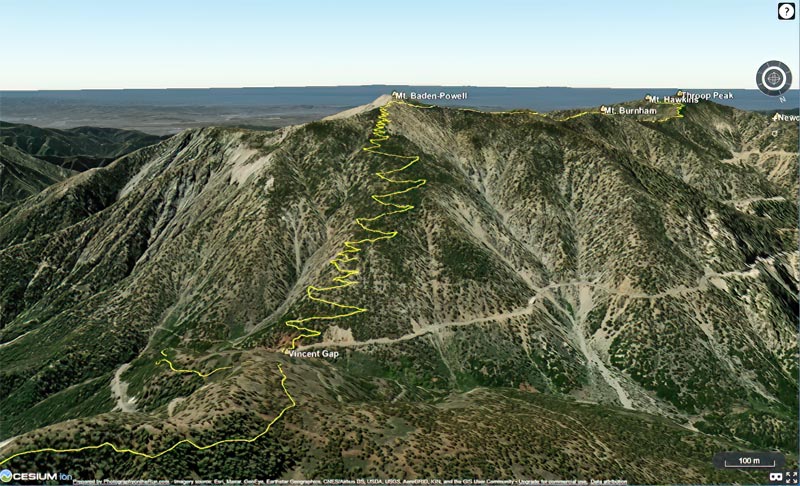
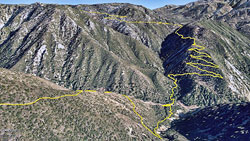
In addition, here is an interactive, 3D terrain map of the 2023 Angeles Crest 100 Mile Race. It is based on the course GPX file downloaded from the AC100 website. The map is initially zoomed in on the climb up Mt. Baden-Powell. To change the view, use the control on the upper right side of the screen. Track and placename locations are approximate and subject to errors.
Click to view 2023 AC100 course with photographic 3D terrain.
See the AC100 website for official information and details.
When I parked at Malibu & Piuma to do the Bulldog Loop on Sunday, I didn’t know that I was going to be swept up in a Bulldog Ultra training run.
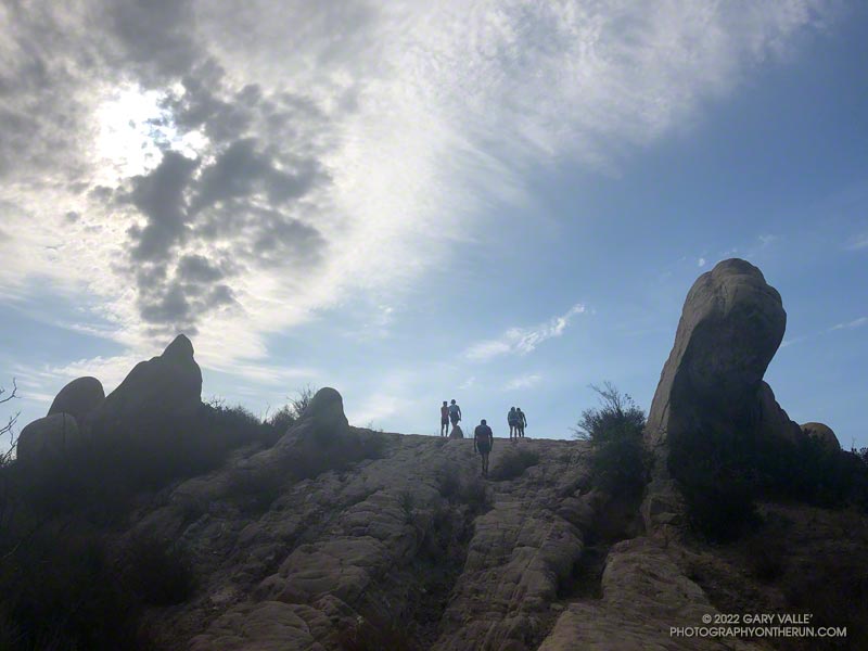
I had just started up Bulldog Mtwy fire road when the first group of speedy runners swarmed past. The strenuous climb to the Castro Peak Mtwy gains about 1750 feet over 3.4 miles. Much of its infamy is due to the oven-like conditions typically experienced on the second loop during the Bulldog 50K.
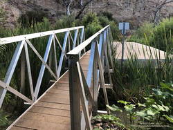
New bridge extension across Malibu Creek on the Crags Road trail, east of the M*A*S*H site.
This morning, the climb was a little warm in spots, but not bad. There was a good turnout for the training run and nearly everyone was enjoying the run.
On the way up I had an interesting conversation with a runner that had just done their first 100 miler and was going to pace someone in the AC100 this weekend.
In case you haven’t heard, State Parks has finally come up with a solution to the repeatedly washed-out footbridge across Malibu Creek, east of the M*A*S*H site. An extension was added to the massive block of concrete that formed the foundation of the old bridge. No more shaky log crossings — at least for a while.
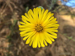
Common Madia (Madia elegans) at the bottom of the Bulldog Mtwy fire road.
Here’s an interactive, 3D terrain view of the Bulldog loop. The map can be zoomed, tilted, rotated, and panned. To change the view, use the control on the upper right side of the screen. Track and placename locations are approximate and subject to errors. Poor weather and other conditions may make this route unsuitable for this activity.
Good luck to all the runners doing Bulldog — especially those doing their first trail race or ultra!
Just 48 hours before the start of the Diablo Trails Challenge the temperature on Mt. Diablo’s summit was a chilly 31°F. Gray, wind-driven clouds shrouded the summit, propelled by 20-30 mph winds. Over the 10 days preceding the race, it had rained on four, and Concord had received about two inches of rain.
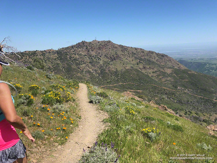
That’s the thing about Spring weather – a couple of days can make a huge difference. Today – race day – the sun is out, the hills are green and skies blue. Very little mud remains – the trails are in great shape and hills sprinkled with wildflowers. It’s the perfect day for a run on Mt. Diablo!
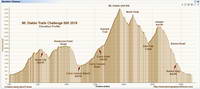
Diablo Trails Challenge 50K Elevation Profile
With around 7000′ of elevation gain/loss, the Diablo Trails Challenge 50K is characterized by its many ups and downs. The core of the 50K course is the 7 mile, 3000′ climb from the Curry Canyon Ranch aid station to Diablo’s main summit. But before you can enjoy this fine ascent, you have to get to Curry Canyon Ranch. And it’s on the other side of the mountain – about 12.5 miles away. Here’s a 3D interactive view of my GPS track of the 50K course.
Along the way there are several get-your-feet-wet creek crossings and many hills. Following along on the map, the course works its way past Wall Point, Artist Point, Knob Point and finally Windy Point. Did I mention the course is hilly?
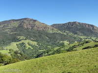
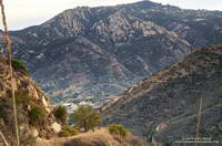
Somewhere around Mile 10 you get the first good view of Mt. Diablo and North Peak. The runner in front of me exclaimed, “Holy guacamole, is that what we are going to climb?” My choice of words were similar, but not quite as polite. Yes indeed, those were the peaks, and they loomed LARGE across the valley.
Mt. Diablo (left) and North Peak
Elevation gained is so easily lost. After gaining about 2500′ on the way to Windy Point, a 1000′ descent leads to the Curry Canyon Ranch Aid Station. The climb of Diablo starts here, but you really don’t feel like you’re on the mountain until you reach South Gate Road and the Curry Point Aid Station, about three miles up the canyon. The grade in Curry Canyon is moderate and I tried to take advantage of that, knowing steeper terrain was ahead.
The Half-Marathoners joined the course at Curry Point — adding their enthusiasm and company – but they were soon headed back down, leaving us to cope with the Summit Trail all on our own.
“Jalapeño chip?,” I asked the runner hiking up the hill next to me. He smiled and said something like, “Maybe next time.” I did what I could to keep from constantly looking up at the summit. I munched on chips, talked to runners and hikers, read the “Trail Through Time” interpretive signs, looked at wildflowers and enjoyed the great views. As long as you keep putting one foot ahead of the other — and maybe smile from time to time – summits will eventually arrive.
Yahoo! The Summit Aid Station! There is almost no wind. In the sun it’s comfortably warm and in the shade comfortably cool. As at the other aid stations, the volunteers are great, helping me to get my hydration pack sorted and get me on my way. After seven miles of uphill, a little downhill is going to feel really good.
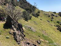
North Peak Trail near Devil’s Pulpit.
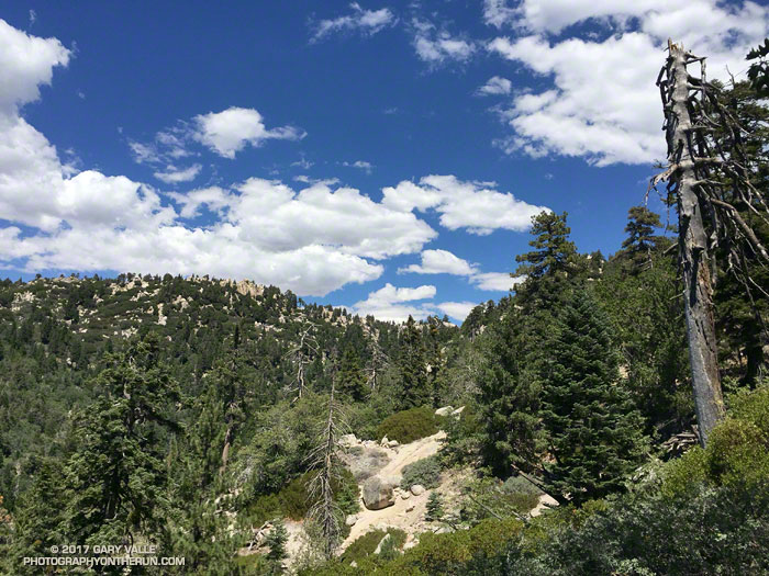
The next few miles I’d done before and they are among the most interesting on the course. It helped to be familiar it – especially the notoriously steep section of North Peak Road, just before the summit. Everyone picks a different route. This time I stayed on the left going up and the right going down, and didn’t fall on my butt!
Once past the “slide” it didn’t take long to get down to Prospector’s Gap. I recalled that the running on the Bald Ridge Trail was excellent and wasn’t disappointed. At Meridian Ridge Road we left Bald Ridge and descended into Mitchell Canyon. At Deer Flat Creek, once again the course headed up. I couldn’t recall how long the climb was going to be, but it looked like we were going to have to work over a high ridge to get to the Castle Rock side of the mountain. The ridge turned out to be Moses Rock Ridge and the climb over it fit right in with the other hills on the course. Click, click goes the elevation-gained counter.
Most of the course is a big loop, but to access the peaks and aid stations there are four short out and back sections. You get to know the runners around you on these sections and we’d give each other encouragement as we passed. The runners around me were great and throughout the run we had many good conversations.
Then there was Burma Road. Somewhere around mile 26, I commented to another runner that we were running out of miles and at some point we were going to have to lose a lot of elevation. The Burma Road descent took care of that.
Many thanks to Jasmin and Sam of Brazen Racing for putting together such a superb event! And a BIG thank you to all the volunteers, ham operators, runners, park staff, sponsors and especially the Save Mount Diablo Foundation. I thoroughly enjoyed running on Mt. Diablo!
I looked at the mileage on my Garmin watch — 11.93 miles. I was at Kanan Dume Road and debating whether to make Kanan my turnaround point. My run had started at Malibu Canyon Rd. & Piuma Rd., where I’d picked up the Sean O’Brien Trail Runs course at around mile 2. After crossing Malibu Creek, the 100K, 50M, 50K and Marathon courses all follow the Backbone Trail westbound from Malibu Canyon.
The ground had been spotted with raindrops as I started the nearly 3 mile, 1500′ climb out of Malibu canyon. Subtropical moisture was streaming in from the southwest and there was a broad swath of clouds over Southern California. There were scattered showers, but most of the rain was evaporating before it reached the ground. The last time it had rained was more than a month ago, and the smell of rain was intoxicating.
A short downhill on Mesa Peak Mtwy before the next climb.. Click for larger image.
Two weeks ago I’d done this climb as part of a “reverse” Bulldog loop. It hadn’t become any less steep. Most of the climb is on a fire road and some of it is runnable — just how runnable depends on your VO2max, determination and inclination. It was a relief to reach the top and start running downhill, even if another climb loomed just ahead.
Rock gateway on the Backbone Trail. Click for larger image.
Once to the top of this next climb, it is about a mile and a half to Corral Canyon. There are a couple of short ups and downs along the way and the rock formations become increasingly dramatic. Just east of Corral Canyon the Backbone Trail winds through a wonderland of rocks and pinnacles, climbing a steep sandstone ramp and passing through a rock gateway.
A tranquil spot along the Backbone Trail in Upper Solstice Canyon.
From Corral Canyon the Backbone Trail drops into Upper Solstice Canyon. Today, the 16 crossings of the small creek in the canyon were all dry. Someone had provided log seats under a sprawling oak at “heart” meadow. I had to stop for a moment just to enjoy its tranquility. On a run here in January several years ago, the area was covered in ladybugs.
Gate on Newton Mtwy on Castro Peak. (Not on the Backbone Trail.)
The high point of the 50K course follows the climb out of Upper Solstice Canyon and is near the saddle at Newton Mtwy. Back in the day the Bulldog 50K used to climb up and over the shoulder of Castro Peak from the top of Bulldog; then descend to this saddle and continue to Corral Canyon on the Upper Solstice Canyon Trail. This 2004 Los Angeles times article describes why the road is now gated and private.
Hummingbird Sage along the Backbone Trail
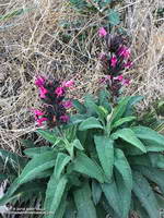
The day was a little warmer than expected and the shaded sections of trail in Newton Canyon were refreshingly cool. The dried out stalks of last year’s hummingbird sage were common along the trail and given the lack of rain, I was very surprised to find a plant that was blooming.
The Sean O’Brien Marathon turns around at Kanan Dume Road, which is what I should have done. That would have resulted in a pleasant 24 mile training run with a bit over 5000′ of gain. Instead I decided to continue west on the Backbone Trail and “just run down to the bridge” to see if there was any water in Zuma Creek. There wasn’t. The bridge also would have been a perfectly good turnaround point that would have netted a 26 mile run.
But it was one of those rare, long run kind of days where the mind and legs are in sync and the miles almost didn’t matter. I reasoned that the Sean O’Brien 50K turnaround was “only” another mile and a half away, so why not continue. That way I’d have an even better idea of what to expect on race day.
Descending Mesa Peak Mtwy into Malibu Canyon.
I did continue, and with the exception of running low on water, everything went well. At Latigo Canyon several runners had just returned to their cars and I was able to fill up my Camelbak(R). Thanks Lou! And thanks to the other runners at the trailhead for their offers of gels, beer and salt!
I’ve run that section of the Backbone Trail several times, but never as an out and back. I now understand why the times for the Sean O’ Brien 50K are a little longer than the typical 50K. For one thing the course is about 1.5 mile longer than a 50K. For another, it has a TON of elevation gain. Using the elevation profile from my fenix 3 and a 1/3 arc-sec DEM from the USGS, the hand-calculated elevation gain worked out to be around 6000′. Tack on another 500′ of gain to account for the Tapia Spur Trail and the total gain for the Sean O’Brien 50K works out to a stout 6500′, give or take.
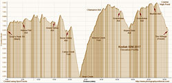
I had heard runners behind me since the last aid station. Now that we had passed the 8000′ high point of the course and were headed downhill, the group was going to pass me. I was at about mile 47 of the Kodiak 50 Mile race, and trying to shake off some demons that had been plaguing me for the last 7 miles.
It was my fourth Kodiak 50M and except for these last few miles it had been a mostly enjoyable day on the trails and forest roads of Big Bear Lake. There is no better run than a run in the mountains, and for my money no better 50 Mile race in Southern California than the Kodiak 50M. The Kodiak races (100M, 50M, Front 50K, Back 50K) have a character all their own, and at least for now — no lottery or histrionics. Just enter, train hard and then run!
Early in the race on Snow Slide Road.
The race had started before dawn near Fawnskin, on the north side of Big Bear Lake. It had been a chilly forty-something degrees at the trailhead, but warmed quickly as we ascended the Grays Peak Trail. Today would be the first day of a record-setting heat wave in SoCal and temps for the race would be the warmest in its five year history. By the time we reached Snow Valley and were descending the windless, exposed, south-facing slopes of Bear Canyon, the “in the sun” temps would be around 100.
The highlight of the 50M race for me is the climb out of Bear Canyon on the Siberia Creek Trail. This classic 7 mile ascent gains around 2910′ from Bear Creek (4770′) to the Champion aid station (7680′). You only get to do the Siberia Creek climb when the 50M is run counter-clockwise around the west end of the lake. This has been the case each year except for 2016.
The descent into Bear Canyon and climb out on the Siberia Creek Trail. Click for a larger image.
Expecting it to be hot and knowing how tough this climb can be, I filled my Camelbak(TM) to the brim and also took an extra bottle. (Thanks Aaron and Lacey!) What I didn’t do was take the time to cool off in the stream. A couple minutes of cooling here might have helped keep the race demons at bay.
It was deceivingly cool in the shade of the trees along Bear Creek, but that didn’t last long. By the time I got to the top of the Siberia Creek climb I was just about out of water, dehydrated and over-heated. I laughed when I thought about how cold it was here in 2013. That year racers resting at the Champion aid station huddled in blankets and sipped hot soup to try and stay warm. Not today! I tried to take the time to rehydrate, but the clock was ticking. I grabbed a cup of ice and started up the fire road.
Elevation profile for the Kodiak 50M. Click for a larger image.
Though still generous, the cutoffs for the 50 milers have been substantially tightened since the 2015 event. Descending from the Grandview aid station to the Aspen Glen aid station I knew I was close to the cutoff and that was confirmed when a runner coming up the trail told me I only had 5 minutes remaining. The aid station personnel at Aspen Glen were phenomenal and I was in and out of there with water, my headlamp, and a couple of GUs in 48 seconds. I was excited to have made the cutoff, but knew I was going to have to push it to make the Finish by 9:00 p.m.
I had forgotten just how far east the Pine Knot Trail goes before ascending to Grandview. At one point it seemed the trail was going to descend all the way to the lake. I hadn’t seen a trail marker in some time and no other runners were in sight. I began to think I might have missed a turn and stopped to look more closely at the tracks on the trail. The imprints of a Brooks Cascadia and Altra Olympus stood out from the others. They were as good as a trail marker, and assured me I was still on course.
The ups and downs of the Kodiak 50M course. Click for a larger image.
Eventually the Pine Knot Trail and I found our way back up to the Grandview aid station, but somewhere along the way I had become nauseated. Without asking, my body decided blood would be more useful for cooling and propulsion than for absorbing fluids and nutrients. My stomach had one message for me, “Sorry, we are closed!” It’s a common issue in longer runs, and given time, most runners work through it.
Unfortunately time was at a premium; all I could do is ralph, turn onto the Skyline Trail, and take the first steps toward the last aid station. I felt a little better after that and could sip a little water. The good news was that along with the sun, the temperature and my water requirements would be going down. What wasn’t going down was the trail. My recollection of this section was that it was a long five miles, but I did not recall all the ups along the way.
The last mile of the trail to the aid station paralleled the next section of the course and from time to time a runner would shout encouragement from the road above. I’d hoped to make it to the last aid station without having to stop and put on my headlamp and pulled into the station by the light of a quarter moon. Still nauseated, I put on my light and headed up the road.
Like a wrangler movin’ stock down from the high country, sweep Vanessa Kline encouraged the group of runners. We only had about 3 miles to go.
“You gotta keep running! You can do it! If you don’t run, you won’t make the cutoff!”
Most of the group did just that; they kept running and made the cutoff. Despite Vanessa’s best effort to get me moving a little faster, I crossed the finish line seven minutes after the 9:00 p.m. deadline.
I would have liked to make the cutoff, but I’m OK with the unofficial finish. I wasn’t trying to get UTMB points or to qualify for a 100 mile — I was running Kodiak for fun. I like the course and the way the event is organized. I’ve had faster Kodiak times and I’ve had slower. What didn’t change was that I was still smiling at the Finish.
Many thanks to R.D. Matt Smith, his supporting staff, all the volunteers, the sponsors, and runners. For all the results, photos and more info see the Kodiak web site and Facebook page. Also be sure to check out Kodiak 100M Winner Ruperto Romero’s interview on UltrarunnerPodcast.com. It’s a compelling and insightful story.