Category Archives: wildflowers

Soggy Shoes, Soppy La Jolla Valley, and Sensational Wildflowers

Approaching Mugu Peak from La Jolla Valley
Approaching Mugu Peak.

After doing a climbing /trail running combo in Pt. Mugu State Park last Sunday, I headed back to Wendy Drive this morning to do a trail run to Mugu Peak and back.

The plan was to get in a long run (20 miles) with fewer “get your feet wet” stream crossings, and also check out the conditions on several trails I hadn’t done this year.

Boney Mountain (left skyline) from Mugu Peak

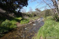
So much for keeping the feet dry! The temp was in the mid-30s when I turned off Big Sycamore Canyon fire road and onto Wood Canyon fire road. The main creek draining Sycamore Canyon cuts across the fire road here, and there was no way I was going to get across it without wading. Some smaller stream crossings followed, ending with Wood Canyon Creek.

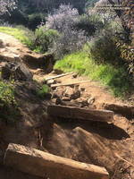
My shoes were squish-squashing loudly as I started up Hell Hill. The 600′ climb was almost enjoyable with the cool temperatures. Partway up, a slurry of rock and mud had flowed from the hillside onto the road — the soil saturated from storm after storm.

California poppies mixed with lupine along the Mugu Peak Trail

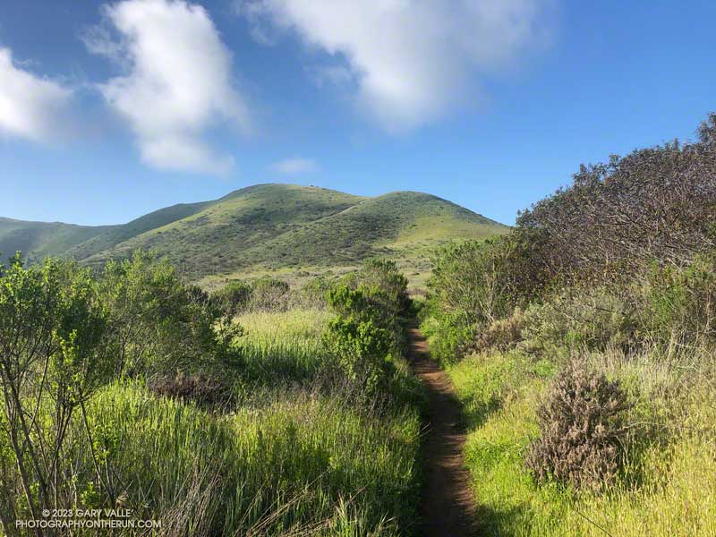
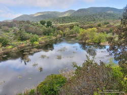
Several trails/roads converge at the top of Hell Hill, and I turned right onto the fire road that leads to the La Jolla Valley Loop Trail. I like to do Mugu Peak as part of a counterclockwise loop that combines segments of the La Jolla Valley Loop Trail and Mugu Peak Trails.

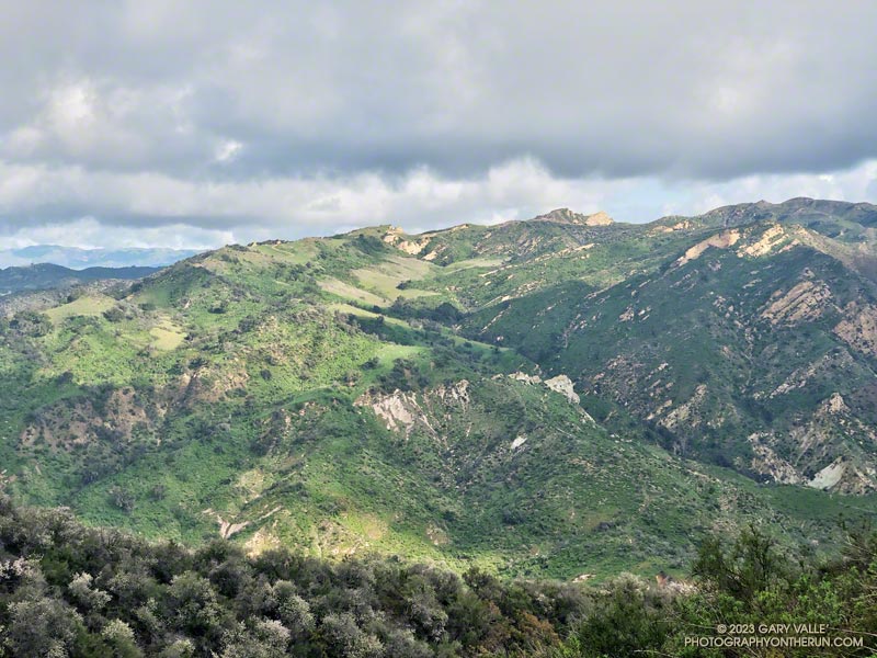
Long stretches of the La Jolla Valley Loop Trail between the walk-in camp and Mugu Peak were sopping wet. I’ll be curious to see how quickly it dries out, but today (April 2) it was really, really wet.

La Jolla Loop pond in La Jolla Valley in Pt. Mugu State Park.
La Jolla Loop pond is rarely this large — or even a pond.

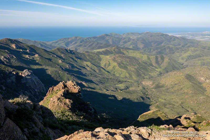
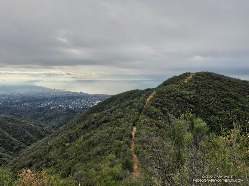
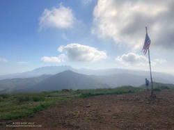
Mugu Peak was pretty much as it always is on this side — busy and steep. The steepness of the “Direct” trail helped wring the water from my Ultraglides and Injinji socks. By the time I reached the top, my feet were only damp.

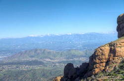
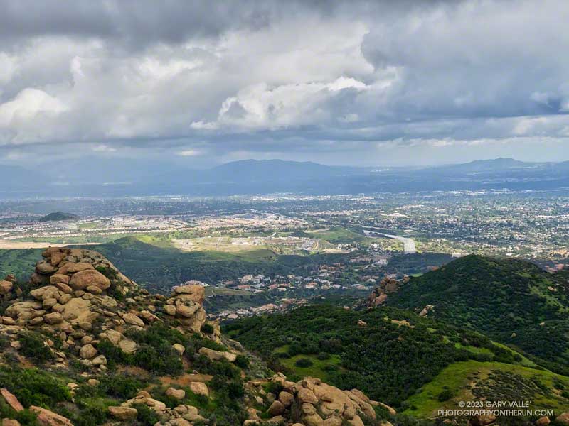
Mugu Peak is VERY popular, and there are almost always a few people taking in the wide-ranging views from the summit. Most do the short, steep hike from PCH on the Chumash Trail. A few start at the Ray Miller Trailhead — or like I was doing today — the long route from Wendy Drive.

Vivid red paintbrush along the La Jolla Loop Trail in Pt. Mugu State Park.
Vivid red paintbrush along the La Jolla Loop Trail

Although I usually climb the peak, two other options are worthwhile: the loop around the ocean-facing side of Mugu Peak and
the loop around La Jolla Valley.

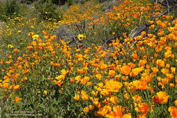
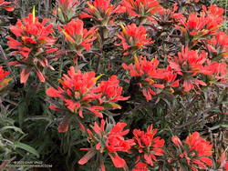
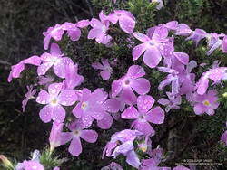
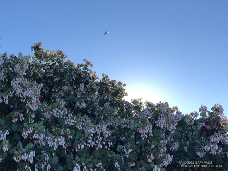
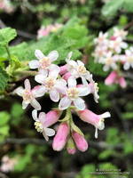
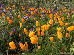
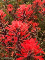
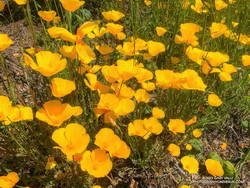
The wildflowers along the Mugu Peak Trail and La Jolla Loop Trail were fantastic. California poppies were plentiful on the south-facing slopes. The vibrance of the bright orange poppies could not have been better accentuated than by purple lupine. Yellow bush sunflower, royal blue phacelia, and rich red paintbrush also decorated the trail.

Bright yellow collarless poppies along Danielson Road.

I followed my usual route on the way back to Wendy — returning to the Hub, descending Hell Hill, retracing my steps in Wood Canyon, then following the Two Foxes single-track trail north to a short connector to Sycamore Canyon Road. This is near the Danielson Multi-Use Area. Once on Sycamore Canyon Road, the route back was the same as last week — up 1.8 miles of paved road and then onto the Upper Sycamore Trail. After that, up Danielson Road and across Satwiwa to the Wendy Drive trailhead.

Here is an interactive, 3D terrain map of my GPS track to Mugu Peak and back from Wendy Drive. To change the view, use the control on the upper right side of the screen. Track and placename locations are approximate and subject to errors. Poor weather and other conditions may make this route unsuitable for this activity.

Also, see the archived maps of Rancho Sierra Vista/Satwiwa and Pt. Mugu State Park from the NPS website, and the maps of Pt. Mugu State Park on VenturaCountyTrails.org.

Some related posts: Out and Back Trail Run to Mugu Peak, Running to Serrano and La Jolla Valleys from Wendy Drive, Busy Mugu Peak

Backbone Trail Mystery

Pt. Mugu State Park from Boney Mountain

The morning was beautiful and sunny. It hadn’t rained for two days, and except for a few contrails, the sky was nearly cloudless.

Earlier in the morning, I’d climbed the Western Ridge of Boney Mountain, then worked my way over Tri Peaks to the Backbone Trail. I’d been on cruise control running down the Chamberlain/Backbone Trail, enjoying the pleasant weather and wide-ranging views.

Hines Peak and other Ventura County Mountains from the Chamberlain segment of the Backbone Trail

Passing a gap in the ridge, I was surprised to see a person on the hillside, a few yards below the trail. It was an odd place to be.

The person was partially hidden by grass and brush, and all I could see was their head and shoulders. They were wearing an odd helmet and were busy working on something that looked like a pack. I didn’t see a mountain bike.

None of it made sense. Was it someone doing the Backbone Trail? Had they slept there overnight? What was with the helmet? Reaching the end of the Chamberlain Trail, I turned right on the Old Boney Trail and continued the descent toward Blue Canyon.

California poppies and bush sunflowers along the Old Boney Trail

Partway down, I heard the clap-clap-clap of helicopter blades approaching the canyon, and that’s when it all fell into place. The mysterious person along the Chamberlain Trail was a SAR crew member.

The helicopter was yellow, probably from the Ventura County Sheriff Search and Rescue Aviation/Medical Team. I’ve seen them in the area a number of times doing exercises.

This wasn’t the first time I’d seen something strange from the Chamberlain Trail. A few years ago, I’d noticed an odd-looking object below the Chamberlain and Old Boney Trails junction. It turned out to be a rescue manikin strapped onto a litter. Practice makes perfect, and exercises help ensure the safety and success of demanding SAR operations.

Stream crossing on the Blue Canyon segment of the Backbone Trail.
One of several stream crossings in Blue Canyon.

Farther down the Backbone Trail, there was a striking display of California poppies and bush sunflowers on the hillside above the junction of the Backbone and Old Boney Trails. After photographing the poppies, I returned to the Backbone Trail and entered Blue Canyon. To this point, I’d managed to keep my shoes and socks dry. But that was going to end.

I’d done a similar route in January, partly to see the condition of the Chamberlain, Blue Canyon, and Upper Sycamore Trails. That was the case again today. In the two months since the January run, nearby Circle X has recorded over 13 inches of rain. Not surprisingly, that has resulted in more water in the streams, more wildflowers along the trails, and a bit more eroded and rougher trails.

Some related posts: Looking for Storm Damage in Point Mugu State Park, Pt. Mugu State Park Debris Flows and Flash Floods (2014)

Rainy Weather Running on Rocky Peak Road

San Fernando Valley from Rocky Peak Road.

I like splashing through streams as much as anyone does, but today I wanted to try and keep my shoes and socks dry. This Winter that’s been surprisingly hard to do.

Weekdays, I often run from the Victory trailhead at Ahmanson Ranch over to Las Virgenes Canyon and back. But it had rained in the Los Angeles area for four days straight. There was just no question that Ahmanson was going to be wet and muddy, and Las Virgenes Creek would be too wide to jump. I’d have to wade the creek crossings — again.

Paintbrush (Castilleja affinis) along Rocky Peak Road

That’s why this afternoon, I was doing an out-and-back run on Rocky Peak Road from the 118 Frwy trailhead. As a result of the area’s sandstone geology, Rocky Peak Road is usually a pretty good place to run during periods of wet weather. For one thing, there are no creeks to cross. Plus, the rocky and sandy road doesn’t have many areas of “glob on your shoes” mud. It also has excellent views of the San Fernando and Simi Valleys and surrounding mountains.

My turnaround point today was the top of the Chumash Trail, which is a little less than four miles from the Rocky Peak trailhead. I sometimes continue past the Chumash Trail another mile to Fossil Point.

Today, there was one short, muddy stretch that could be mostly avoided and a few large mud puddles I could walk around. At the end of the run I didn’t have to switch shoes to drive home!

Some related posts: A Bear on Rocky Peak Road, Chilly Rocky Peak, Mountain Lion Tracks on Rocky Peak Road, Rocky Peak Vernal Pool

Out and Back Trail Run from the Top of Reseda to Parker Mesa Overlook

Upper Santa Ynez Canyon and Eagle Rock from East Topanga Fire Road

The view from Parker Mesa Overlook was the uniform gray of the inside of a cloud. I was about 30 minutes too early, and the low clouds hadn’t cleared. The Pacific Ocean was out there somewhere.

Even so, the run from the Top of Reseda to the Overlook had been excellent. The hills and canyons were painted in a muted palette of sun and shadow. Purple-pink prickly phlox brightened the roadside, and the “Beech-nut Gum” scent of Bigpod Ceoanthus filled the air.

Prickly phlox along East Topanga Fire Road

Fire Road #30, Eagle Springs Fire Road, and East Topanga Fire Road had all been cleared of the sluffs and slides that resulted from January’s rainstorms. Overnight, there had been a little drizzle, but the fire roads hadn’t been muddy at all.

Rather than just retracing my steps, on the way back to the Top of Reseda I opted to do the Musch and Garapito Trails. I had run the Garapito Trail in mid-January but hadn’t been on the Musch Trail since the January deluge.

The Trippet Ranch parking lot had been packed, and several groups appeared to be on their way to Eagle Rock via the Musch Trail. Overall, the trail weathered the storms reasonably well, but one badly eroded section and a couple other spots will need some work.

Section of the Musch Trail damaged in January 2023 rainstorms.
Damaged section of the Musch Trail

While it still had some issues, use of the Garapito Trail had moderated its condition since the last time I was on it. Some brush that had blocked the trail had been removed, and paths were evolving through the collapsed sections of trail. However, some extra care was still required in some spots.

The Bent Arrow Trail was closed, necessitating a return to dirt Mulholland on Fire Road #30, following the same route as had been used at the beginning of the run.

Here is an interactive, 3D terrain view of a GPS track (yellow) to Parker Mesa Overlook from the Top of Reseda. The Bent Arrow Trail is temporarily closed for repair and is shown in red. To change the view, use the control on the upper right side of the screen. Track and placename locations are approximate and subject to errors. Poor weather and other conditions may make this route unsuitable for this activity.

Some related posts: More Malibu Creek Flooding, Looking for Storm Damage in Point Mugu State Park, Popular Trails in Topanga State Park Damaged by Winter Storms

Bigberry Manzanita – A Hummingbird Hotel

Bigberry Manzanita - A Hummingbird Hotel

From a hummingbird perspective, it was the perfect place to spend a cold night.

The big berry manzanita was situated on the spine of a north-south oriented ridge near Topanga Lookout. In that location, a bird might benefit from the warmth of both the setting and rising sun.

In addition, the bush’s thicket of stiff branches afforded some protection from predators, and the multitude of nectar-rich blossoms would provide a badly needed boost of wake-up energy.

The temperature was warmer now, but it had been near freezing at the Cold Canyon trailhead when I started the Topanga Lookout Ridge loop. It had been cold enough that I had jogged the steeper sections of Calabasas Peak fire road, just to ward off the chill.

Humans are funny that way — a small drop in body temperature can be life-threatening. How in the world can a diminutive hummingbird, whose caloric needs require it to feed almost constantly, survive a long, cold Winter night?

Research reveals that hummingbirds accomplish this feat by reducing their body temperature and metabolic rate. This physiological state — called torpor — dramatically reduces their energy requirements.

This particular manzanita apparently receives a lot of 5-star reviews, and at the time I passed, was occupied by several buzzing birds.

From Sunday’s run of the Topanga Lookout Ridge loop.

Related post: Hummingbird Stories

Racing the Weather to High Point (Goat Peak) and Back

High Point (Goat Peak), Santa Monica Bay, and clouds.
High Point (Goat Peak)

The forecast for the Los Angeles area (Saturday, December 10) was for a chance of rain in the afternoon, with rain developing overnight and continuing into Sunday morning. There was also a slight chance of light rain or drizzle in the Santa Monica Mountains in the morning.

It was overcast in the West Valley as I drove to the trailhead, and I wondered if my run would be dank and drizzly. But as I drove up Reseda Blvd. toward Marvin Braude Mulholland Gateway Park, I was surprised to find patches of blue sky overhead.

Sunrise view of Hondo Canyon, Topanga Lookout, and Henry Ridge in the Santa Monica Mountains.
Hondo Canyon, Topanga Lookout, and Henry Ridge from the top of Fire Road 30.

I started the run a little before 7:00 a.m. and headed up the connecting single-track trail to dirt Mulholland and Fire Road 30. Many runs from the Top of Reseda start this way, and I turned onto Fire Road 30 and continued up to the Hub — about 2.5 miles from the trailhead.

For the first couple of miles, I wasn’t sure how long a run I would do or where I was headed. But as I neared the Hub, I had to make a decision. To a large extent, a decision that depended on the weather.

What had been partly cloudy skies had coalesced into a layer of clouds that just touched the top of the highest peaks. I’d been thinking about doing an out-and-back to High Point (Goat Peak), but if the weather continued to deteriorate, the only view I would see from the peak would be the interior of a cloud. I finally decided to give it a go and hope the peak didn’t get socked in with clouds and fog.

Chaparral currant (Ribes malvaceum) along the Backbone Trail
Chaparral currant

Turning left at the Hub onto the Temescal Ridge Fire Road segment of the Backbone Trail, I ran about a half-mile to where the Backbone Trail forks left off the fire road and becomes a single-track trail. This is the popular Rogers Road segment of the Backbone Trail that eventually ends at Will Rogers Historic State Park.

From Temescal Ridge Fire Road, it’s about 4.25 miles on the Backbone Trail to the unsigned junction with the High Point use trail. It’s on the right and easy to miss. The turnoff is about a half-mile before “The Oak Tree” landmark on the Backbone Trail.

The High Point trail is an unofficial, unmaintained path but is usually in decent shape. There are a couple of short, steep, loose sections on the way to the peak. Nothing is signed, and some side paths diverge from the main trail.

Summit of High Point (Goat Peak), with the San Gabriels, Downtown, and West L.A in the background
Summit of High Point (Goat Peak)

When I reached High Point’s summit, the weather was holding but looked more threatening. Even so, the view was excellent. Panning from east to west underneath the ceiling of clouds, the view included the San Gabriels, Downtown, West L.A., the South Bay, Santa Monica, Palos Verdes Peninsula, Santa Monica Bay, and Catalina.

There were a couple of rogue sprinkles on the way back to the Top of Reseda, but the rain held off in the West Valley until late in the day.

Here is an interactive, 3D terrain view of the High Point (Goat Peak) Out and Back from the Top of Reseda. The map can be zoomed, tilted, rotated, and panned using the navigation control on the right. Track and placename locations are approximate and subject to errors. Poor weather and other conditions may make this route unsuitable for this activity.

Some related posts: High Point (Goat Peak) Via the Rivas Ridge Use Trail, Goat Peak and the High Point Trail