Category Archives: running|adventures

After the Springs Fire: A Run Through Pt. Mugu State Park

New growth in Pt. Mugu State Park following the Springs Fire

As we rounded a corner on the Old Boney Trail, Ann spotted a deer bounding through a thick, unburned section of brush. Its behavior was unusual — the deer was a few hundred yards away and in heavy cover. We soon saw the reason — a large coyote was trailing the animal and probably had been doing so for time.

We were in the middle of a 25 mile Odyssey through Pt. Mugu State Park, about three weeks after the Springs Fire ravaged much of the park’s 14,000 acres.

Already the process of recovery was underway. Tufts of green were sprouting in many areas. Yucca was beginning to regrow and a few yucca scorched in the fire were blooming. In addition to the deer and coyote described above, over the course of the run we would see another deer; fresh raccoon, bobcat, fox and rodent tracks; a lizard, grasshoppers, many birds, a bee’s nest, and fresh mountain lion scat.

Here is a slideshow of some photos from the run.

Some related posts: Springs Fire Burn Severity, Springs Fire 2013

San Francisco Sights Trail Run

Golden Gate Bridge from the Batteries to Bluffs Trail

The Presidio of San Francisco is a favorite of local and visiting runners. One of innumerable route variations, this 7.5 mile run is jam-packed with iconic sights and memorable points of interest.

Brett and I started the run near the Chestnut gate of the Presidio. The first stop was the Letterman Digital Arts Center, the headquarters of Industrial Light and Magic and LucasArts. You can grab a cup of coffee at the Starbucks here, and then stop by the Yoda Fountain. Statues of motion picture pioneer Eadweard Muybridge and TV pioneer Philo T. Farnsworth are also on the grounds.


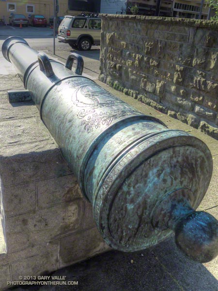
Circling around to the Letterman complex entrance we returned to the Presidio gate at Lyon & Lombard, which is flanked by two 18th century bronze Spanish cannon. The 6-inch caliber (24-pounder) cannon are marked with the ornate cipher of King Carlos III.  The information imprinted on the breech ring indicates they were cast two days apart in Seville in December 1783. Even older Spanish cannon can be found at the Officers Club and elsewhere in the Presidio.

Turning right (south) we ran a few blocks up Lyon Street to the popular Lyon Street steps. There are two groups of steps, the first set being steeper than the second. One of San Francisco’s most exclusive neighborhoods, Pacific Heights, borders the steps.


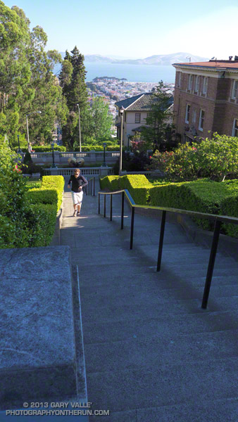
If you check online you’ll see counts of the Lyon Street steps ranging from around 241 to 291. Brett & Amanda counted the steps by section on another occasion and counted 63, 62, 46, 60, and 60 steps — for a total of 291 steps. The curb in the middle near the basketball hoop was not counted.

From the top of the Lyon Street stairs we re-entered the Presidio at Broadway, crossed Presidio Blvd, and then continued west along West Pacific Avenue. Wood Line, the first of two Andy Goldsworthy pieces passed on the run, is below West Pacific Avenue and between Lovers Lane and Presidio Blvd.

In about a half-mile we picked up the Bay Area Ridge Trail near the Arguello Gate and the Presidio Golf Course Clubhouse. Although not included on our route today, Inspiration Point is nearby and can be visited using the upper Ecology Trail.


Following the Bay Area Ridge Trail we crossed Arguello Blvd and continued uphill a short distance to Andy Goldsworthy’s Spire. Today Spire pointed into a clear blue sky, but on other days it can be nearly lost in fog. Over time, the young cypress and pine trees surrounding Spire will grow to dominate the skyline and Spire will shrink until it becomes a lost thought from another time.

About a half-mile beyond Spire the northwest-trending Bay Area Ridge Trail turned west, near the connector trail to the National Cemetery Overlook. Following the trail we continued west, past Rob Hill Campground to Washington Blvd. and then joined the Coastal Trail at the Pacific Overlook.

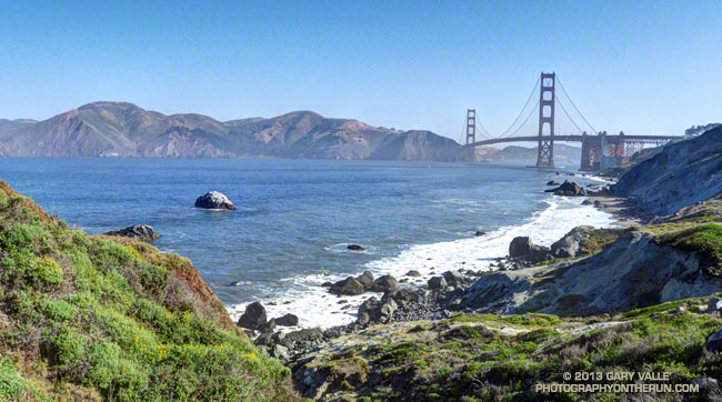
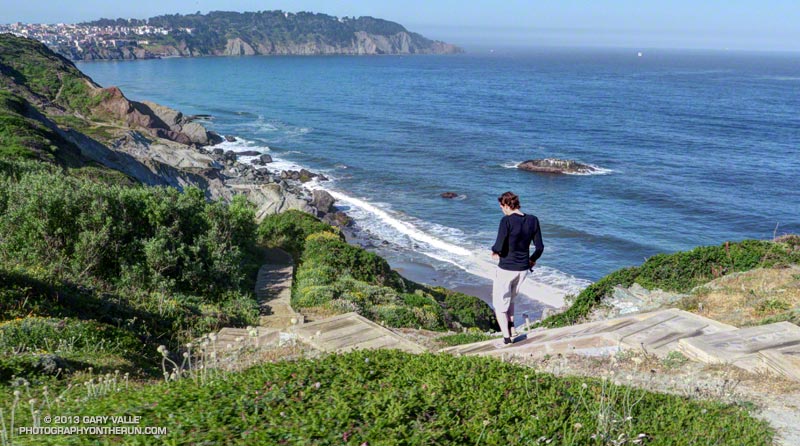
Here the iconic views of the Pacific shoreline and the Golden Gate begin. Taking advantage of the superlative weather, we ran down the Batteries to Bluffs Trail toward Marshall’s Beach and south to Battery Crosby, looping back up to the Coastal Trail and the Pacific Overlook.

The fantastic views continued as we ran north on the Coastal Trail, past Battery Geoffrey and other fortifications that protected the Golden Gate. Running under the Golden Gate Bridge we left the Coastal Trail (which crosses the bridge) and ran down the Battery East stairs to the Golden Gate Promenade.


Not that much bigger than a large container ship, Alcatraz looked like a huge tramp freighter out in the bay, steaming through the morning haze. Already late for breakfast, we tried to keep the pace up as we ran along the Promenade. At Crissy Field I paused for a moment to photograph Huru, one of Mark di Suvero’s huge steel sculptures.

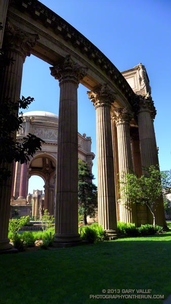
Leaving the shoreline at the marina, we crossed Marina Blvd. One more stop was on our itinerary — the Palace of Fine Arts. Built for the Panama Pacific International Exposition in 1915, and rebuilt in 1965-66, architect Bernard Maybeck’s vision was that of “a Roman ruin, mutilated and overgrown.”

Out of time, I took a few photos and we checked on the nest of the swans Blanche and Blue Boy, residents of the Palace’s lagoon. One swan was on the water, but the nest was empty. Later we learned that four cygnets had hatched just days before.

Here’s a slideshow of some photos from the run. This interactive Cesium browser View shows the GPS track of our route. Here also is a Park Service & Presidio Trust map of the Presidio (PDF).

Some related posts: Spire, Wood Line, Cooler Running, Inspiration Point – Golden Gate Bridge Loop

Trail Running Weather

Running Down the South Fork Trail from Islip Saddle

Just six days before I’d been sitting in my car at Islip Saddle debating whether to run. It had been COLD. The temperature had been about 35°F and the wind a steady 20 mph with higher gusts. It was cloudy and at times foggy, and it looked like rain, sleet or snow might begin at any moment.

Mt. Baldy from Mt. Baden-Powell.

Today I was back at Islip Saddle and the temperature was definitely not in the 30s. On a scale of 1 to 10, today’s trail running weather was going to be a 9 or 10. At least here in the San Gabriel Mountains the weather was going to be a 9 or 10. Down in the valleys the temps would hit the mid-90s in some locations.

We were doing the Islip Saddle – South Fork Camp – Vincent Gap – Mt. Baden-Powell loop, one of my favorite adventure runs in the San Gabriels. Because this loop starts by running down to the high desert heat is often a factor, and an early start desirable.

Western wallflower (Erysimum capitatum), a member of the Mustard family
Western wallflower along the Pacific Crest Trail.

Running down the South Fork Trail it felt like it was going to be a great day for the run, and by the time we were chugging up the Manzanita Trail toward Vincent Gap, there was no doubt about it. There was a cool, down-canyon breeze, and even in the sun the temperature was pleasant. The hatch of gnats that usually follows Spring showers wasn’t happening and all in all the conditions were as good as I’ve had on the loop.

Here is a slideshow with a few photos from the run, and here are an interactive Cesium browser View and an elevation profile of the run.

Some related posts: Heat Wave, San Gabriel Mountains Running Adventure, Bear Cubs on the South Fork Trail, Islip Saddle – Mt. Baden-Powell South Fork Loop

Cold Spring – Romero Loop

Forbush Canyon Trail in the Santa Barbara Back Country

This is an adventurous loop that starts and ends at the Cold Spring trailhead, low on the slopes of the Santa Ynez Mountains in the Santa Barbara Front Country. The route climbs the Cold Spring Trail to Camino Cielo on the crest of the range, and then descends to Forbush Flat and Blue Canyon in the Santa Barbara Back Country.

The Front Country views on the Cold Spring Trail are spectacular, and the Back Country segment from Forbush to Blue Canyon has a classic, isolated character, accentuated by grassy flats, sprawling oaks, gurgling springs and unique geology. Montecito Peak (3214′) can be climbed on the way up the Cold Spring Trail and depending on how much time you spend on the summit, adds about 15 minutes.


I was running with Kevin Young, whom I’d met during the Backbone Ultra. Kevin is long-time resident of Santa Barbara and this is just one of the challenging routes in his backyard. As is the case with many trail runs, the mileage of this loop — about 22 miles — isn’t the best indicator of its difficulty. Many variations of the loop are possible, but one thing they all have in common is lots of elevation gain.

Thanks to the marine layer it was cool along the immediate coast, but inland temps were hot. When we started the run the temperature at the Montecito RAWS was 60°F. A few hours later when we were climbing out of Blue Canyon on the memorably steep Romero Trail the in-the-sun temperature at nearby Los Prietos was around 100°F.


Having done this loop a number of times, Kevin knew it was longer than it looked, and had stashed some goodies at the Romero trailhead. You might think 100 oz. of water would be plenty for 16 miles. On a different day it might be, but today we both ran out of water part way down the Romero Trail. Neither one of us had particularly fresh legs. Kevin was training for a 100 miler later in May and had run 20 miles the day before.

The PB & J sandwich at Romero hit the spot, but after drinking a 16 oz. recovery drink, half of a large bottle of water, and some Gatorade, I wondered if I had overdone the fluids. Nope — it actually helped a lot and my running attitude improved considerably.

Kevin’s route back to the Cold Spring trailhead from Romero initially followed the Nine Trails course on the Edison Catway, but after reaching the Buena Vista Trail continued down to Park Lane. Here we picked up the Old Pueblo Trail, and then worked across to the McMenemy Trail. We followed the McMenemy Trail to the Hot Springs Trail, which we took down to Mountain Drive. From the Hot Springs trailhead it was about a mile on Mountain Drive back to the Cold Spring trailhead. Even though it had a lot of up and down, this part of the run turned out to be surprisingly cool and enjoyable.

For maps of the area see the Santa Barbara Hikes web sites.

Here’s a slideshow with a few photos from the run. We did this run last Sunday, April 28.

Snow, Sadie and Mt. Baden-Powell

View southwest from Sadie Hawkins past Twin Peaks to Mt. Wilson
View Southwest from Middle Hawkins past Twin Peaks to Mt. Wilson

The snow was rock hard and covered with lodgepole pine needles and other debris. Having experience climbing snow and ice I can usually deal with a little early season snow, but I could see no way to safely cross this patch. The snow was steep and icy, the runout long and the risk high. My usual tricks for crossing short stretches of snow were not going to work.

Snowfall had been sporadic in Southern California over the Winter and this was the earliest in the Spring I had tried to do the out and back from Islip Saddle to Mt. Baden-Powell. I had thought there might be some patchy snow on the north-facing slopes at the higher elevations, but I hadn’t expected it to be an issue.


Borrowing from river paddling philosophy, you never run (or hike, or ride) the same trail twice. I knew it was going to be an interesting day when a bighorn sheep darted from the trailhead at the beginning of the run. I’d followed bighorn tracks from Islip Saddle up the PCT for about a quarter mile to an overlook of Hwy 39 and Twin Peaks.

The view from the overlook had been spectacular. Marine layer stratus filled the canyon, nearly immersing Triplet Rocks on Twin Peak’s elongated east ridge. The stratus was evidence of a strong onshore flow, but above Islip Saddle a strong — and cold — wind was blowing almost directly out of the north. It had been cold enough that I pulled on my extra sleeves, ultralight shell and light gloves.

The wind was unrelenting and seemed to work its way around every corner and into every canyon. At Windy Gap and the other wind gaps along the crest the wind was funneled and accelerated, and I wondered if this would be the day I would see or hear one of the huge ghost trees from the Curve Fire crash to the ground.


At times I go where my camera takes me, and about a half-mile west of Mt. Hawkins it took me off the PCT and onto the Hawkins Ridge Trail. There are three peaks along this ridge —  Middle Hawkins, Sadie Hawkins and South Mt. Hawkins. It had been years since I’d done these peaks, and today it looked like there might be some good views from the ridge.

The Hawkins Ridge Trail was warm and mostly sheltered from the wind and I continued down the trail a little further than necessary before leaving it and scrambling up to the summit of Middle Hawkins. Warmed from the steep climb I had returned to the PCT and continued toward Baden-Powell.


Near the junction of the PCT and Dawson Saddle Trail there had been patches of snow mixed in with the chinquapin and limber pines, but it hadn’t been until the PCT skirted north around Mt. Burnham that the trail was blocked by snow. I abandoned the attempt to cross the icy patch and headed up the steep slopes of Mt. Burnham to the crest.

It was still cold and windy when I reached the summit of Mt. Baden-Powell, but a sparkling day with Mt. Baldy to the southeast across Vincent Gulch, San Jacinto Peak and San Gorgonio area peaks in the distance to the southeast, the Sierra to the north, and miles of stratus to the south. After spending a few minutes on the summit I retraced my steps back down the crest and the PCT to Islip Saddle, making the requisite stop at Little Jimmy Springs along the way.

Some related posts: San Gabriels High Five, La Nina Looming, Running Hot & Cold, Toward Triplet Rocks

Unwinding from the Backbone Ultra

Bear Canyon
Bear Canyon

Doing a moderate run in the San Gabriels and climbing a few peaks was a great way to unwind from the excitement of doing the 68 mile Backbone Ultra last weekend.

I felt good. I’d run more or less normally in the week following the event — depleted, but without any physical issues. In part that can be attributed to how Coyote Cohorts runs their events. It was basically a long training run in the company of a great bunch of runners and the help of incredible volunteers. Amazing! The long hours of training also really helped, particularly the back-to-back runs following 50Ks and the back-to-back night/day training runs. My shoes — Hoka Mafate 2s — also helped, reducing the impact of all the miles.

Paintbrush on the San Gabriel Peak Trail near Markham Saddle.
Paintbrush on the San Gabriel Peak Trail

One of the reasons for doing today’s run was to check how Poodle-dog Bush and some other plants are faring in this low rainfall water year. Since July 1 Downtown Los Angeles has recorded only 5.14 inches of rain. Unless we can manage to wring about a half-inch of rain from the heavens before June 30, this water year will go down as the fourth driest since record-keeping began in 1877. The driest water year on record was in 2005-2006 (3.21 inches). Assuming we don’t get that 0.48 inch of rain, three of the four driest water years have occurred since 2000.

Something I noticed on the Backbone run and recent training runs in the Santa Monica Mountains is that plant growth and flowering has been surprisingly robust given the amount of rainfall. This was also the case today on today’s run — the manzanita on the San Gabriel Peak Trail was covered in blossoms and bees, and the nightshade and paintbrush along the trail also seemed to be doing well.

Prickly phlox along Calabasas Peak Mtwy.

What about the Poodle-dog bush, aka Turricula? It looked about the same as last year at this time — just starting to come out of Winter dormancy. Last year we had above average rainfall in April and it really seemed to spur the growth of Poodle-dog bush. This year maybe we’ll see what an extended period of dry weather does to it. Last year some of the Poodle-dog died before the rain in April.

Here’s a short slideshow of a few photos from today’s run in the San Gabriel Mountains, as well as some photos of plants and flowers on recent runs in the Santa Monica Mountains.