Category Archives: geology

Missing Wildflowers, More Mountain Lion Tracks, and the Serrano Canyon Landslide

Cirrus clouds and Boney Mountain's western rim from the Old Boney Trail

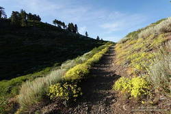
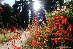
As I worked up the Old Boney Trail, I looked for anything blooming. The empty seed pods from last year’s bigpod Ceanothus bloom were still present on many plants, but not a flower was in sight.

Lack of rain will do that. Although today’s run was after Southern California finally received some rain, the first few months of the rain season had been ridiculously dry. From July 1, 2024, to January 24,2025, Downtown Los Angeles recorded only 0.16 inch of rain — tying 1962-1963 for the driest start to the Rain Year on record.

Purple nightshade along the Old Boney Trail (thumbnail)
Purple nightshade – just about the only early bloomer on 20+ miles of trail.

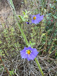
Over the 20+ miles of trail that I would run today, the only conspicuous wildflower was this purple nightshade along the Old Boney Trail. Ceanothus, paintbrush, milkmaids, phlox, poppy, and other early-blooming species might be seen in normal or wet years.

Very early in the run, I came across some disturbing tracks on the Old Boney Trail. I first saw them on Danielson Road, and they continued on Old Boney all the way to Blue Canyon. From the tracks, I could see they powered directly up the hills and sped through the straightaways.

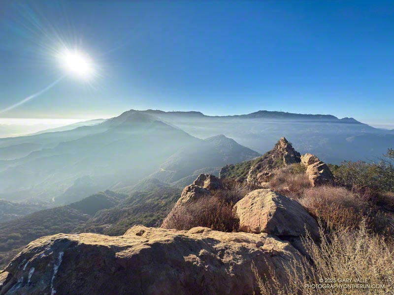
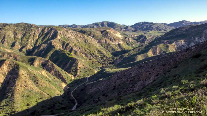
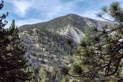
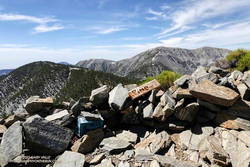
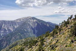
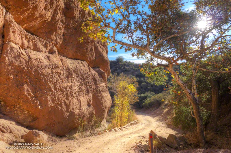
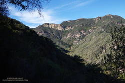
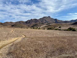
Usually, when I do the long climb out of Upper Sycamore on the Old Boney Trail, it’s to do the Western Ridge (Mountaineer’s Route) on Boney Mountain. This morning, the combination of crags, clouds, and early morning light on Boney Mountain looked especially inviting. I almost turned up the use trail that ascends the ridge. Resisting the impulse, I continued on the Old Boney Trail — past the Fossil, Blue Canyon, and Chamberlain Trails — to the Serrano Valley Trail and Serrano Valley.

Serrano Valley - February 2025 (thumbnail)
Serrano Valley – February 2025

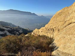
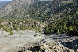
It had been over a year since I’d been to Serrano Valley. It is one of the prettiest spots in the Santa Monica Mountains. It has a “big sky” feel that I always enjoy. When combined with a run down Serrano Canyon, the experience is exceptional.

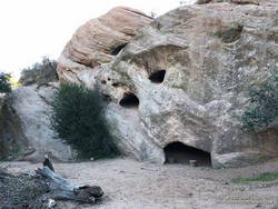
One of the interesting things to see in Serrano Canyon is a large landslide scar on the north side of the canyon, about a half-mile from Sycamore Canyon. The trail goes over the foot of the slide. Some boulders near the trail contain fossils, similar to those found on the Fossil Trail.

As the landslide scar came into view, something had changed — there was a “new” rockslide in the middle of the old landslide scar. When I stopped to take a photo, I could hear rocks and debris trickling down the slope. This suggested the slide was still active and might be very recent. When did it happen?

New rockslide on an old landslide scar in Serrano Canyon (thumbnail)
New rockslide on an old landslide scar in Serrano Canyon.

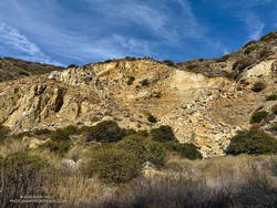
The last time I’d photographed the landslide scar was in February 2022. At that time, this new rockslide hadn’t occurred. I also checked Google Earth. The most recent Google Earth imagery of the landslide scar was from April 21, 2023. It didn’t show the rockslide. Then I checked Sentinel 2 satellite imagery, but that wasn’t high enough resolution to determine the date of the rockslide. High resolution imagery of a relatively small, non-urban area would be required, and it would need to have been taken after April 21, 2023.

After failing to find a suitable image using various services that provide free or low cost imagery, I contacted the Vexcel Data Program. They were kind enough to provide an answer — the new rockslide was not in imagery from September 23, 2023, but was present in an image from October 12, 2023.

The new rockslide occurred about 16 months ago, a month or two after Tropical Storm Hilary  passed through Southern California. For the 24-hour period  ending at noon on August 21, 2023, the weather station at nearby Circle X Ranch recorded  about 3.9 inches of rain.

While searching for imagery of the landslide scar, I stumbled onto UCSB Library’s collection of aerial photography. It contains more than 2.5 million images dating back to the 1920s. Curious to see the quality of the photos, I picked a 1:12,000 scale image from November 1936 that was more or less centered on the landslide scar. The quality of the image is excellent — but where was the landslide? I had assumed the Serrano Canyon Landslide to be an ancient feature. How old is it?

Serrano Canyon Landslide 1947 and 1961 (thumbnail)
Serrano Canyon before the landslide (1947) compared to after (1961). Click!

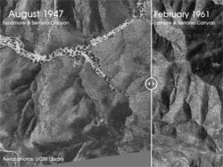
The most recent image I could find without the landslide was from August 1947. The most recent image of the landslide was from October 1959 but it doesn’t show the landslide clearly. The oldest the landslide could be is about 77 years!

The event did not go unnoticed. This 1:16,000 scale aerial photo from February 1961 shows a well-used road going to the landslide. Vehicles are parked at the end of the road and there is activity at the landslide. Here is a before and after comparison of the 1947 and 1961 photos.

Continuing down Serrano Canyon, I stopped at Sycamore Canyon to get some water and decide where I was headed next. Option A was to turn south on Sycamore Canyon Road, go up the Fireline Trail to Overlook Fire Road, and then return to Wendy Drive via Hell Hill, Wood Canyon, Two Foxes, Sycamore Canyon, and Upper Sycamore. Including what I’d already done, that would be about 24 miles. Option B was to turn north on Sycamore Canyon Road and go directly to the Two Foxes Trail, etc. That would be about 20 miles.

Mountain lion tracks along Sycamore Canyon Fire Road, Pt Mugu State Park (thumbnail)
Mountain lion tracks along Sycamore Canyon Fire Road

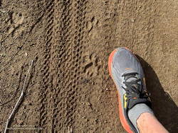
Today, I opted for Option B. That turned out to be an exciting choice. Just before the turn onto Wood Canyon, there was a sequence of mountain lion tracks along the east side of Sycamore Canyon Road. To better show its size, I superimposed the track on top of my shoe. The shoe is about 4.5 inches wide at the center of the track. There were also deer tracks along the road.

Here is a high resolution, interactive, 3D terrain view of the Old Boney – Serrano Valley Loop from Wendy Drive. Two options are shown. The map can be zoomed, tilted, rotated, and panned. To change the view, use the control on the upper right side of the screen. Track and placename locations are approximate and subject to errors. Poor weather, and other conditions may make this route unsuitable for this activity.

Some related posts:
Back on the Old Boney and Serrano Valley Trails
Old Boney to Serrano Valley, Plus Fireline and Overlook

Exploring Calabasas Peak’s Southeast Ridge

Topanga Ridge, Lookout and Saddle Peak from Calabasas Peak's southeast ridge.
Topanga Ridge, Lookout, and Saddle Peak from Calabasas Peak’s Southeast Ridge.

On the way down from Saddle Peak last Sunday, the “knob” at the end of Calabasas Peak’s southeast ridge caught my eye. For some time, I’ve been curious about the ridge and the unique sandstone ribs that form its backbone. The odd knob at the end of the ridge just increased my curiosity.

Calabasas Peak from the Stunt High Trail. (thumbnail)
Calabasas Peak from the Stunt High Trail.

This morning found me running (and hiking) up Calabasas Peak Mtwy. fire road towards Calabasas Peak. My rough plan was to do Calabasas Peak, explore the rock formations along the peak’s southeast ridge, and then do Topanga Lookout Ridge Loop and Saddle Peak.

Near the top of the fire road, I stopped to take a photo of the rock formations and rising sun. The marine layer created a peculiar veil of fog and haze that accentuated the rocks and ridges.

After a quick ascent of Calabasas Peak, I returned to the viewpoint at the top of the fire road and started working down the southeast ridge. A steep, brushy, convoluted, little-used path wound down and around the tops of the rock ribs along the ridge to a small clearing at a saddle below the “knob.”

Sandstone rib on Calabasas Peak's Southeast Ridge. (thumbnail)
Sandstone rib on Calabasas Peak’s Southeast Ridge.

It turned out that it was not a knob but another rocky rib that looked like a knob when viewed head-on. It was relatively easy to access the rib from the clearing. I ascended the rib until I ran out of rock, then descended it to a point below where I had joined it.

I briefly debated continuing down the ridge but decided to retrace my steps and return up the ridge to the viewpoint.

Once back on the fire road, I jogged down to its junction with Red Rock Road and started up Topanga Lookout Ridge. The rib at the end of Calabasas Peak’s southeast ridge doesn’t look anything like a knob from Topanga Lookout Ridge!

Later in the run, when I was on the way down from Saddle Peak, I looked across the canyon at the “knob” on Calabasas Peak and smiled. Checking it out had been an enjoyable adventure.

Wandering Around Malibu Creek State Park

Century Dam from the end of the Forest Trail in Malibu Creek State Park.

Here are a few images from a meandering run in Malibu Creek State Park on the Cistern, Lookout, Crags Road, Forest, and Chaparral Trails.

Some related posts:
Spring Fever Running the Phantom Loop in Malibu Creek State Park
Malibu Creek State Park: Lake Vista Ridge, the Forest Trail, and September Wildflowers
Afternoon Run on the Forest and Lost Cabin Trails in Malibu Creek State Park

Exploring Las Llajas

Las Llajas Canyon, in the northeast corner of Simi Valley.
Las Llajas Canyon

First published in March 2008.

At times the site of a religious colony, a grit mine, an oil field, and a housing development, Las Llajas Canyon is now part of the Marr Ranch Open Space and Rocky Peak Park. Its oak groves, gurgling stream, varied plants, and unique geology make it a popular place to hike, run or ride.

According to California Place Names, Las Llajas might have originated from a misspelling of the Spanish word “llagas,” which literally means sores or wounds. Perhaps this was a reference to the area’s natural oil seeps. These would have been an important resource for the Chumash and early settlers.

The trailhead for Las Llajas Canyon is on Evening Sky Drive in Simi Valley. From the trailhead, it’s about 3.4 miles up the (mostly) dirt road to a windmill and oak-shaded trail junction. From the junction, a connecting trail crosses the creek and then climbs steeply to Rocky Peak Road. A strenuous 9.2 mile loop — Chumash-Las Llajas Loop — follows this route.

There are also some less-used side trails in Las Llajas Canyon. A use trail on the canyon’s east side starts about 0.4 mile from the trailhead and connects to Rocky Peak Road near the highest point in Rocky Peak Park. A very steep, eroded hill marks the beginning of the route. The trail ends at a large cairn near Rocky Peak Road. Fossiliferous limestone, composed of seashells, is found here. It is similar to that found at Coquina Mine.

The Coquina Mine trail starts about 1.9 mile from the Las LLajas trailhead. It climbs “Tapo Alto Mountain” on the west side of Las Llajas Canyon and appears to follow the route of a dirt road shown in the U.S.G.S. 1941 Santa Susana Quadrangle topo map.

About a half-mile up the trail splits — the Coquina Mine use trail switches back to the right, while a trail connecting to the Marr Ranch Trail continues straight ahead. After the switchback, the Coquina Mine trail traverses across a steep, rocky face that overlooks Las Lajas Canyon and then continues to the top of the peak. As the trail winds up the mountain, there are bits and pieces of rusted mining equipment and abandoned dig sites — signposts of success and failure on the meandering trail of time.

Thumbnail: P&H Model-206 Corduroy Power Shovel. Click for a larger image.
P&H Model-206 Corduroy Power Shovel

At the end of the trail, a few feet from the summit of the peak is a P&H Model-206 Corduroy power shovel. Nearly out of mountain, its bucket is poised to scoop another load of crushed seashell, waiting for its operator to return. Here’s a short video walk around the power shovel.

From P&H Mining Equipment:

“Thank you so much for this extraordinary image of a P&H 206! Our company built Model 206 machines during the 1920s and 1930s. They were offered in shovel configuration, such as the machine you discovered in Southern California, and also in construction crane, dragline, clamshell, pile driver and backhoe options. It is amazing to behold such a well-preserved Model 206. The arid environment must be a factor.”

The 1941 Santa Susana topo map shows two “COQUINA” mines in the area. They are labeled “TAPO COQUINA MINE” and “COQUINA MINE.” The mines are described in the Ventura County section of a 1947 California Journal of Mines and Geology report, “Limestone in California.” From the report:

“During the last 20 years there has been irregular production from deposits of shell limestone on Rancho Simi, north and east of north from Santa Susana. The quarries are on hills 2 1/2 miles apart and 1 to 2 miles from the Los Angeles County line.”

The report goes on to summarize the operation at Coquina Mine:

“In 1929 Tapo Alto Shell & Fertilizer Company leased the deposit and produced limestone until 1935. They dug limestone with a 1/4-cubic-yard gasoline shovel, and screened and crushed it in a plant having a daily capacity of 15 tons. The principal product was poultry grit…”

A more detailed description of the mine’s operation is found in the 1932 REPORT XXVIII OF THE STATE MINERALOGIST:

“Present quarry is 200 feet long by 70 feet wide, with a 40-foot face. Material is handled by gasoline shovel, having a 1/4-yard dipper, into a l 1/2-ton truck which hauls it about 200 feet to the brow of the hill where it is dumped into a chute 300 feet long. This chute empties into a hopper which discharges into the boot of an elevator; to trommel screen, 4-mesh, screenings to bin, thence to elevator and Cottrell vibrating screens ; products to two-compartment bin ; over-size from trommel to rolls and bin. The plant is so arranged that either product can be put on dump by means of a conveyor. Plant is operated by 25-h.p. Fairbanks Morse gas engine. Plant has a daily capacity of about 15 tons. Products are — 8 + 10-mesh for chickens and — 10-mesh for little chicks.”

Some related posts: Chumash-Las Llajas Loop, Not So Flat Las Llajas Canyon

A Warm Day on Blue Ridge and the North Backbone Trail

Clouds, pines, and Pine Mountain from Blue Ridge in the San Gabriel Mountains

Angeles Crest Highway was still closed between Red Box and Vincent Gap, and the heatwave continued. I was trying to decide where to run.

I briefly considered the Circuit Around Strawberry Peak, but yesterday at 10:00 a.m., the “in-the-shade” temperature at Clear Creek was already 92°F, and the “in-the-sun” fuel temperature 109°F. By 1:00 p.m., the fuel temp reached a scorching 122°F!

Although trailheads such as Three Points and Islip Saddle couldn’t be accessed using Angeles Crest Highway, the highway was open from Wrightwood to Inspiration Point and Vincent Gap. After seeing the temps at Clear Creek, it took about two seconds to make the decision to head to the San Gabriels’ high country.

 sulfur flower-lined section of the PCT east of Inspiration Point
sulfur flower-lined section of the PCT east of Inspiration Point

From Inspiration Point (7,365′), I ran east on the PCT about 7 miles to the North Backbone Trailhead on Mt. Baldy. Over most of that stretch, the temperature was a blissful 60-something degrees. Other times, I’ve driven to this trailhead — which requires a high-clearance vehicle — or run to the trailhead from Wrightwood. But the run along Blue Ridge is a favorite. It is especially scenic, with fantastic views of Mt. Baden-Powell, Iron Mountain, Pine Mountain, and Mt. Baldy.

About a quarter-mile east of the top of the Acorn Trail, the PCT passes within a few feet of one of the Wright Mountain landslides. The canyon-size landslide is prehistoric, but smaller landslides and mudflows occur periodically within the primary scar. The debris cone of a dramatic 1941 mudflow is an unmistakable feature on satellite photos.

Peak 8555 and Pine Mountain from the PCT.

Less than a mile beyond the overlook of the landslide, I left the PCT and jogged down to the North Backbone Trailhead. After a short descent, I started up the steep use trail toward Peak 8555. On the way up, San Gorgonio Mountain and San Jacinto Peak were visible in the haze to the east.

Peak 8555 is the first high point on Baldy’s North Backbone. It is an idyllic spot with a great view of Mt. Baden-Powell and the surrounding terrain. But you might not want to linger here in a thunderstorm — spiral scars on the trunks of trees suggest the point is repeatedly struck by lightning.

Crossing the top of a chute on Mt. Baldy's North Backbone.
Crossing the top of a chute on Mt. Baldy’s North Backbone.

Following a short descent, I resumed climbing the steep, somewhat loose ridge. After about ten minutes, I scrambled onto the crest of the ridge and crossed the top of a prominent, rocky chute. More than a thousand feet below, avalanche-hardened snow gleamed white in the sun at the base of the chute.

Another 10 minutes of climbing and I reached the Pine Mountain Juniper. Straddling the rocky crest at an elevation of about 9000′, this stalwart tree is estimated to be 800 – 1000 years old. It is a remarkable tree in a remarkable location. Except for one short, steep, eroded section, the remainder of the trail to the top of Pine Mountain (9648′) was relatively straightforward.

Dawson Peak and Mt. Baldy from Pine Mountain's south summit.
Dawson Peak and Mt. Baldy from Pine Mountain’s south summit.

Pine is the second-highest peak in the San Gabriels and has excellent views of the surrounding terrain. It is higher than Mt. Baden-Powell (9399′) and Dawson Peak (9575′) but a few hundred feet lower than Mt. Baldy (10,064′).

From Pine Mountain, the North Backbone trail continues over Dawson Peak another 2.5 miles to Mt. Baldy. There was still a long ribbon of snow along the east side of the upper North Backbone, but it looked like the trail might avoid it. I would have liked to confirm that, but today the top of Pine was my planned turnaround point. As it was, with the warm weather, I thought I might run short on water on the return to Inspiration Point.

Leaving Pine behind, I started back down — jogging when it made sense — but trying not to do anything stoopid. On the way down, I kept reaching behind me and squeezing the bladder in my hydration pack. I guess I was hoping that it would magically be more full than the last time I checked. It never was.

San Gabriel beardtongue along the PCT on Blue Ridge.

Back at the North Backbone Trailhead, and definitely low on water, I decided it was a good time to run the dirt road back to the top of the Acorn Trail and see how much shorter it was than the PCT. The answer was not much — only about a tenth of a mile.

I’d been willing to push the water envelope because it had been a heavy snow year. I expected the spring near Guffy Camp would probably be running. I’d passed the side trail to the spring a bunch of times but never ventured down the steep slope. My impression was that the spring was often low or nearly dry. This time when I reached the side trail, I headed down.

Pumphouse at Guffy Spring, surrounded by giant larkspur.

And down and down… It sure seemed like a long way to the spring, but when I checked the track, it was less than a quarter-mile with an elevation loss of about 200′.

As I walked up to the spring, a flurry of birds scattered in every direction. Eight-foot-tall larkspurs surrounded the spring, and an old pump house was adjacent to it. While not exactly gushing, the flow from the spring was more than adequate and refreshingly cold. I drank several cups of water and added some to my hydration pack.

Clouds over Mt. Baden-Powell from the PCT east of Inspiration Point
Clouds over Mt. Baden-Powell

Back on the PCT, the temperature was generally in the mid-eighties but was warmer on south-facing slopes. At about 1:00 p.m., the in-the-sun fuel temperature at the Big Pines RAWS was 109°F. I was very happy to have the extra water.

Here are a few photos from the out and back trail run to Pine Mountain from Inspiration Point.

Explore the scenery and terrain of this out-and-back trail run and hike from Inspiration Point to Pine Mountain using our high resolution,  interactive, 3D viewer. The imagery is so detailed, it’s almost like being there! To change the view, use the control on the upper right side of the screen, the CTRL key and your mouse, or touch gestures. Track and placename locations are approximate and subject to errors. Snow, ice, poor weather, and other conditions may make this route unsuitable for this activity.

Some related posts: Inspiration Point to the Pine Mountain Juniper and Pine Mountain, Mt. Baldy from Wrightwood Via the Acorn and North Backbone Trails, North Backbone Trail Revisited

Red Rock Canyon – Hondo Canyon – Saddle Peak Loop (3D Terrain Map)

Red Rock Canyon, near Topanga, California.

It was clear and cool when I started up Calabasas Peak fire road from the trailhead on Stunt Road.

Several good trail runs and hikes start here; among them are out and backs to Calabasas Peak and Saddle Peak and an adventurous loop up Topanga Lookout Ridge to Topanga Lookout and Saddle Peak. This morning’s trail run was also going to be a loop, and it was a loop that I hadn’t done before.

Two-thirds of a mile of uphill on the dirt road brought me to a bench and the top of Red Rock Canyon. This is also where the use trail up Topanga Lookout Ridge begins. This time, instead of starting up the ridge, I turned right onto the fire road and began the winding descent into Red Rock Canyon.

Sandstone rock formation in Red Rock Canyon.

In the canyon, there are Sespe Formation sandstone rock outcrops with a variety of intriguing shapes and colors. About a mile from Calabasas Peak Mtwy is the parking area for Red Rock Canyon Park. From here, the road continues a little less than a mile to Old Topanga Canyon Road.

Running 1.5 miles on a narrow canyon road with little or no shoulder can be hazardous to your health. Doing the run early on a Sunday morning helped. There were about the same number of cyclists as cars, and there weren’t that many of either. The diciest part was a section of road with no shoulder on a blind curve. I was glad to get past that and to the Hondo Canyon Trailhead.

Hondo Canyon from the Backbone Trail in the Santa Monica Mountains.
Hondo Canyon from the Backbone Trail

Hondo Canyon is one of the many memorable sections of the Backbone Trail. From Old Topanga, the trail climbs through oaks, grassland, chaparral, and California bay for about four miles to the Fossil Ridge Trail. The trail hides the 1600′ elevation gain well, and long sections of the trail are runnable.

Just below Saddle Peak Road, the Backbone Trail turns right and follows along Fossil Ridge three-quarters of a mile to the service road used to access Topanga Lookout. A left turn leads to the intersection of Saddle Peak Road, Schueren Road, and Stunt Road at the Lois Ewen Scenic Overlook.

The antennae-festooned west summit of Saddle Peak in the Santa Monica Mountains
Antennae-festooned west summit of Saddle Peak.

The remainder of the loop follows the same route as the Topanga Lookout Ridge – Saddle Peak loop. Initially, it follows the Backbone Trail west, past a large water tank to a spur trail that goes to the twin summits of Saddle Peak. The West summit, with all the electronics, is slightly higher, but is now closed. The flat East summit is about a quarter-mile from the Backbone Trail.

Returning to The Backbone Trail and continuing west, it’s about 1.25 miles down to the Stunt High Trail junction. From there, it’s another 2.6 miles on the Stunt High Trail down to the Calabasas Peak/Stunt High trailhead and the end of the 14.3 mile loop.

Here is an interactive, 3D terrain view of the Red Rock Canyon – Hondo Canyon – Saddle Peak loop. The Topanga Lookout Ridge route is also shown. The map can be zoomed, tilted, rotated, and panned using the navigation control on the right. Track and placename locations are approximate and subject to errors. Poor weather and other conditions may make this route unsuitable for this activity.

Some related posts: Red Rock Canyon from the Red Rock Trail; July Fourth Trail Run to Trippet Ranch, Hondo Canyon and Saddle Peak; Topanga Lookout Loop, Plus Saddle Peak