Category Archives: weather|southern california

San Gorgonio Mountain: Dry Lake – Fish Creek Saddle – Dollar Lake Loop

Sky High Trail on San Gorgonio Mountain

Sky High Trail a Mile from the Top of San Gorgonio Mountain

Time flies when you’re having fun, and except for kayaking the upper Santa Ana River and a ski ascent or two, the last time I’d been on the north side of San Gorgonio was before Poopout Hill closed in 1988. Curious to refresh my memory of the area and compare a South Fork trail run to those on the Forest Falls side of the mountain, I started thinking about what would be an interesting route to do.


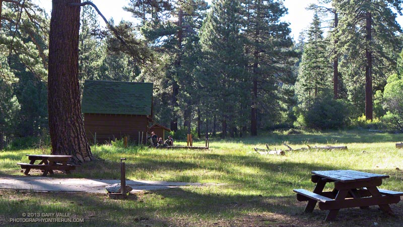
Running in shorts and short sleeves, I’d left the South Fork trailhead about 7:30 and was now about a half-hour into the run. Up ahead was the turn-off to Poopout Hill and not far beyond that the wilderness boundary. I’d been doing a mix of fast hiking and running and enjoying the morning. A black-capped chickadee had stopped on a branch to say hi, and a Steller’s jay was complaining loudly from the top of a pine. Earlier I’d passed Horse Meadows, an iconic scene with sunlight filtering through the trees, green meadows and rustic brown cowboy cabins.


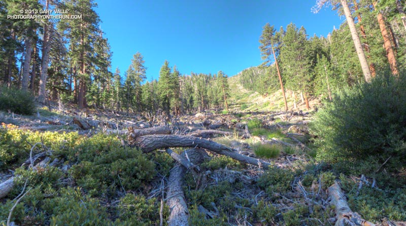
About a quarter mile past Poopout Hill my jaw dropped as I rounded a corner and was suddenly in a sizable avalanche path. A tumult of interleaved  firs and pines lay in a hundred yard wide swath that extended thousands of vertical feet up the mountain.

This avalanche likely occurred within a few days of January 23, 2010, following (or during) a multi-day rain and snow event in Southern California. Over the seven day period from January 17 to January 23, the rain gauge at Mill Creek recorded 7.82 inches of precipitation. According to a NWS report, Mt. Baldy recorded 7′ of snow at the 8600′ level. The source area of the avalanche appears to have been in a cirque near peak 10,230.


Working up the hill toward South Fork Meadows I stopped to chat with a Ranger, who checked my wilderness permit and mentioned a group of day hikers had left South Fork very early and were ahead of me.

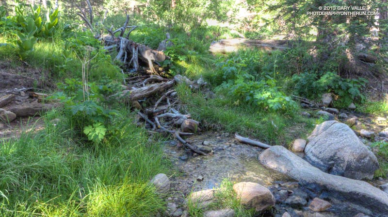
At the Dry Lake/Dollar Lake fork at South Fork Meadows I turned left onto the Dry Lake Trail. I already heard water, so one question was answered — there was plenty of water at South Fork Meadows. Comments on the Water Info Collector had said Lodgepole Spring was low, but “flowing OK,” so the plan was to top off my water there.


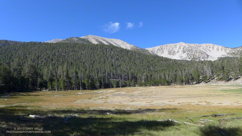
Dry Lake was indeed dry, but the meadow in its place and backdrop of sculptured mountains was still impressive. The next stop was Lodgepole Spring; I just had to find the use trail leading to it. This was one of those situations where it’s important to note the details of the topography. There are two areas that people camp at Dry Lake (noted on a sign) and the use trail is in the drainage above the second, more southerly camp.


After talking to some campers I followed the trail around the east side of Dry Lake and into the primary camping area.  After working up the drainage a couple tenths of a mile I found a small spring flowing out of some willows. Rather than taking the time to use a UV pen, I used a makeshift cup to fill a one liter  collapsible water bottle with a built-in filter. Hopefully that, and what was left in my pack, would get me up to the peak and back down to South Fork Meadows.


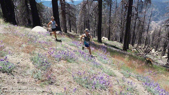
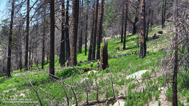
The “use” trail from Lodgepole Spring was not too difficult to follow and it took about 30 minutes to get up to Fish Creek Saddle. The trail between Fish Creek Saddle and Mineshaft Saddle more or less follows the 9880′ contour line and was reasonably runnable. It passes through an area of lodgepole pines killed by the mountain pine beetle.


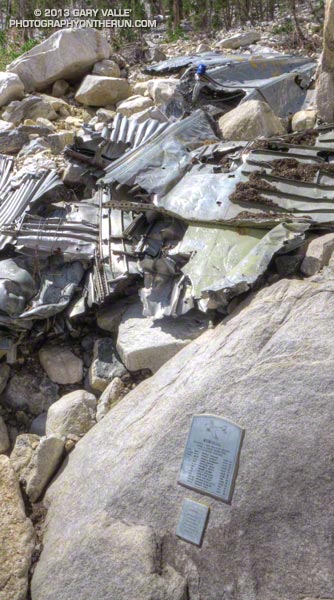
In a few minutes I rejoined the regular Dry Lake route at Mine Shaft Saddle and started up the increasingly scenic Sky High Trail. About a mile up the trail from Mine Shaft Saddle is wreckage and a memorial to the personnel of a Douglas C-47 that crashed in a snowstorm on December 1, 1952. The C-47B “Gooney Bird” was a military version of the venerable DC-3 airliner.

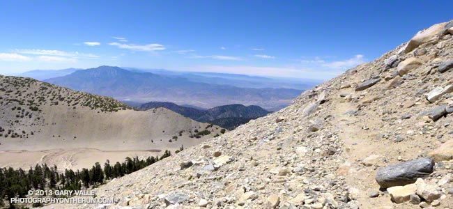
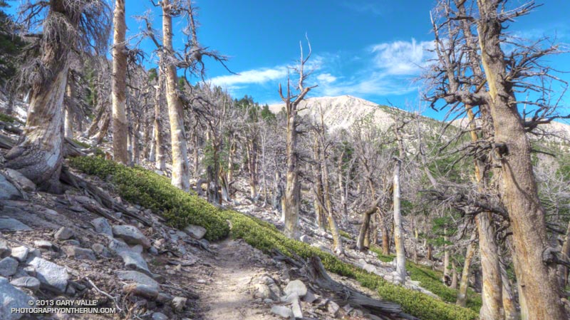
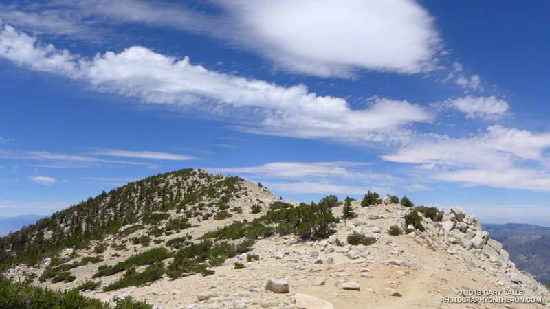
The Sky High Trail earned its name as it switchbacked up to 11,000′, and wrapped around the south side of Gorgonio’s summit. From the  airy trail there are stunning views past The Tarn to Banning Pass and Mt. San Jacinto. The Sky High Trail joined the Divide Trail a little east of the Vivian Creek Trail junction and in a couple of minutes I was jogging east across the summit plateau to the blocky summit of San Gorgonio Mountain.

According to the Trail Mileage Handout (PDF) from the San Gorgonio Wilderness Association the descent from the summit by way of Dollar Lake Saddle and the Dollar Lake Trail is about 10.7 miles — which is a little shorter than the 11.4 miles listed using the regular Dry Lake route. (Mileage doesn’t include the side trip to Lodgepole Spring.) Even so, I think the Dry Lake route is the preferred route from South Fork Meadows. It’s more scenic and aesthetic.


The running was technical, but good down to Dollar Lake Saddle. Below Dollar Lake Saddle the trail was often very rocky. This lightning-scarred pine was on one of the last switchbacks before South Fork Meadows. I was happy to get down to South Fork Meadows, get some water, and get onto a better trail! By about 3:30 pm I was back at the car and enjoying an ice cold bottle of water.

Some related posts: Falls Creek Loop 2012, San Gorgonio High Line 2009

Western Tiger Swallowtail Laying Eggs on Snow Bush

Western Tiger Swallowtail Laying Eggs on Snow Bush

We had run from Mt. Pinos (8831′) to Mt. Abel (~8280′) on the Vincent Tumamait Trail stopping by Sawmill Mountain (8816′) and Sheep Camp (8200′) along the way. Valley temps were forecast be well into the 100s, but here had ranged from a cool 60-something in the shade to the high 70s on the exposed sections of trail — perfect for trail running.

I’d paused at about 8700′ on the way back up Mt. Pinos to take a photo of some phlox, when a western tiger swallowtail flitted past and started to land here and there on a spiney low shrub at the margin of the trail. There was something peculiar about the butterfly’s behavior. Rather than stopping completely, it would hover briefly at one spot and then move to another. There were no flowers on the snow bush where it was hovering, so it wasn’t feeding.

Perhaps 18-24 inches away, the butterfly reacted when I started to move the camera, so I just stood quietly, holding the camera near my waist and took several photos.

A closer look at the photos revealed the butterfly was laying golden-green eggs on the snow bush.

Some related posts: Tiger Swallowtail on Snow Plant, Western Tiger Swallowtail, Vincent Tumamait Trail, Thunderstorm, Atmospheric Dynamics

Three Points Loop Twice

Ann and Skye on trail 10W04, between Mt. Waterman and Three Points

Did the 20 mile Three Points – Mt. Waterman Loop a couple of times this month. The first time was during a heat wave similar to what we’re going through now. It was one of those days when you drive to the trailhead early in the morning, open the car door, and the “brisk” mountain air is a surprising 75 or 80 degrees. After doing the run I checked the temperatures recorded at nearby Chilao, and by 9:00 a.m. the temperature was already at 90°F.


The title photo is of Ann and Skye on trail 10W04, between Mt. Waterman and Three Points. Here’s another photo of them in an area covered with bracken fern on a section of the trail that burned in the 2009 Station Fire. It doesn’t look like it, but they are on a trail!

Last weekend I did the loop again, and the temperature was about 15 degrees cooler. What a difference!

Some related posts: Three Points – Mt. Waterman Loop, Southern Pacific Rattlesnake on the Burkhart Trail, Three Points Loop Plus Mt. Waterman

After the Springs Fire: Checking on the Chamberlain Trail

Rock formations on Boney Mountain from the Chamberlain Trail

It had only been a week since I’d run here, but it was still easy to see recovery in Pt. Mugu State Park was continuing at a steady pace. Along the Hidden Pond, Sin Nombre and Blue Canyon Trails daubs of brilliant green contrasted sharply with the somber tones of black, gray and white left by the Springs Fire.


Hopefully recovery will continue at this pace. Most Southern California fires occur in Autumn, when there is a higher likelihood of rain in the weeks and months following the fire. The Springs Fire started May 2. A late season storm moved through the area May 6, helping firefighters to control the fire. The weather station at Circle X recorded about 0.4 inch of rain that day, but the area might not see that amount of rain again for 6-7 months.

In the coastal mountains the marine layer is also a source of moisture. Many of the area’s plants supplement rainfall by extracting water from the moist air. For example, the scalloped shape and surface of coast live oak leaves, and their spine-toothed margin promote condensation and collection of water. On a foggy day you’ll sometimes see a rain-like pattern on the ground under a live oak tree.


This morning the marine layer was in, and skies were partly to mostly cloudy. This was a good thing. Yesterday (June 1) Pierce College in Woodland Hills set a new high temperature record for the date of 104degF. With the hot weather and low humidity the Powerhouse Fire near Lake Hughes had tripled in size. The switch to an onshore flow would cool temps, increase the humidity, and help firefighters to control that blaze.

Today, in addition to checking on the progress of recovery, I wanted to check on the condition of Chamberlain Trail. The Chamberlain Trail is part of the Backbone Trail and the descent from Boney Mountain one of the best in the Santa Monica Mountains.


Last week, on the way to Serrano Valley, we’d seen that the fire had burned up to trail signs at the junction of the Chamberlain Trail and Old Boney Trail. It had been a close call. Brush at the base of the Chamberlain Trail had been scorched and burned, but the fire had not progressed upslope.

But what you can’t see from the junction is that the fire made a serious run up from Serrano Valley on the south side of Boney Mountain. This can be seen on this Google Earth snapshot of a NASA Landsat Satellite Burn Severity image, but from the image it’s hard to tell if the Chamberlain Trail was overrun or not.

Fortunately only a very short section of the Chamberlain Trail about a 0.4 mile from the Old Boney junction was burned.

Some related posts: A Run Through Pt. Mugu State Park, Springs Fire Burn Severity

Trail Running Weather

Running Down the South Fork Trail from Islip Saddle

Just six days before I’d been sitting in my car at Islip Saddle debating whether to run. It had been COLD. The temperature had been about 35°F and the wind a steady 20 mph with higher gusts. It was cloudy and at times foggy, and it looked like rain, sleet or snow might begin at any moment.

Mt. Baldy from Mt. Baden-Powell.

Today I was back at Islip Saddle and the temperature was definitely not in the 30s. On a scale of 1 to 10, today’s trail running weather was going to be a 9 or 10. At least here in the San Gabriel Mountains the weather was going to be a 9 or 10. Down in the valleys the temps would hit the mid-90s in some locations.

We were doing the Islip Saddle – South Fork Camp – Vincent Gap – Mt. Baden-Powell loop, one of my favorite adventure runs in the San Gabriels. Because this loop starts by running down to the high desert heat is often a factor, and an early start desirable.

Western wallflower (Erysimum capitatum), a member of the Mustard family
Western wallflower along the Pacific Crest Trail.

Running down the South Fork Trail it felt like it was going to be a great day for the run, and by the time we were chugging up the Manzanita Trail toward Vincent Gap, there was no doubt about it. There was a cool, down-canyon breeze, and even in the sun the temperature was pleasant. The hatch of gnats that usually follows Spring showers wasn’t happening and all in all the conditions were as good as I’ve had on the loop.

Here is a slideshow with a few photos from the run, and here are an interactive Cesium browser View and an elevation profile of the run.

Some related posts: Heat Wave, San Gabriel Mountains Running Adventure, Bear Cubs on the South Fork Trail, Islip Saddle – Mt. Baden-Powell South Fork Loop

Cold Spring – Romero Loop

Forbush Canyon Trail in the Santa Barbara Back Country

This is an adventurous loop that starts and ends at the Cold Spring trailhead, low on the slopes of the Santa Ynez Mountains in the Santa Barbara Front Country. The route climbs the Cold Spring Trail to Camino Cielo on the crest of the range, and then descends to Forbush Flat and Blue Canyon in the Santa Barbara Back Country.

The Front Country views on the Cold Spring Trail are spectacular, and the Back Country segment from Forbush to Blue Canyon has a classic, isolated character, accentuated by grassy flats, sprawling oaks, gurgling springs and unique geology. Montecito Peak (3214′) can be climbed on the way up the Cold Spring Trail and depending on how much time you spend on the summit, adds about 15 minutes.


I was running with Kevin Young, whom I’d met during the Backbone Ultra. Kevin is long-time resident of Santa Barbara and this is just one of the challenging routes in his backyard. As is the case with many trail runs, the mileage of this loop — about 22 miles — isn’t the best indicator of its difficulty. Many variations of the loop are possible, but one thing they all have in common is lots of elevation gain.

Thanks to the marine layer it was cool along the immediate coast, but inland temps were hot. When we started the run the temperature at the Montecito RAWS was 60°F. A few hours later when we were climbing out of Blue Canyon on the memorably steep Romero Trail the in-the-sun temperature at nearby Los Prietos was around 100°F.


Having done this loop a number of times, Kevin knew it was longer than it looked, and had stashed some goodies at the Romero trailhead. You might think 100 oz. of water would be plenty for 16 miles. On a different day it might be, but today we both ran out of water part way down the Romero Trail. Neither one of us had particularly fresh legs. Kevin was training for a 100 miler later in May and had run 20 miles the day before.

The PB & J sandwich at Romero hit the spot, but after drinking a 16 oz. recovery drink, half of a large bottle of water, and some Gatorade, I wondered if I had overdone the fluids. Nope — it actually helped a lot and my running attitude improved considerably.

Kevin’s route back to the Cold Spring trailhead from Romero initially followed the Nine Trails course on the Edison Catway, but after reaching the Buena Vista Trail continued down to Park Lane. Here we picked up the Old Pueblo Trail, and then worked across to the McMenemy Trail. We followed the McMenemy Trail to the Hot Springs Trail, which we took down to Mountain Drive. From the Hot Springs trailhead it was about a mile on Mountain Drive back to the Cold Spring trailhead. Even though it had a lot of up and down, this part of the run turned out to be surprisingly cool and enjoyable.

For maps of the area see the Santa Barbara Hikes web sites.

Here’s a slideshow with a few photos from the run. We did this run last Sunday, April 28.