Looking for Ogres in Serrano Canyon

Mustard on the Old Boney Trail.

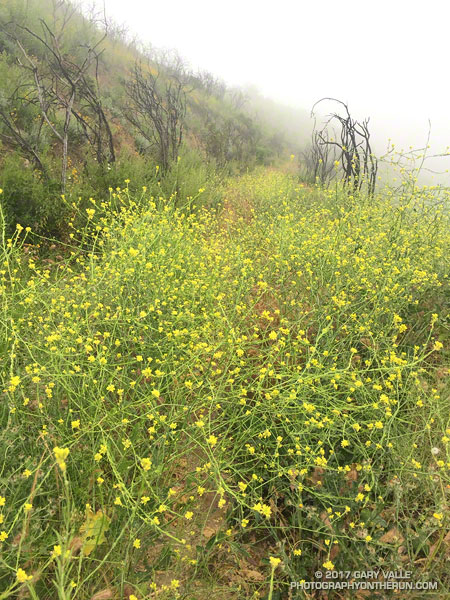
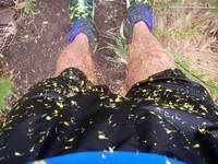
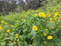
I was covered with bright yellow mustard petals and soaked from head to toe. It had been raining, and I’d just wrestled my way through another tangle of 10 foot high mustard plants. On some parts of the Old Boney Trail the mustard was so thick it was almost impenetrable. The pestilent species becomes especially prolific in wet years, growing rapidly and overwhelming native species and habitats.

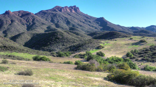
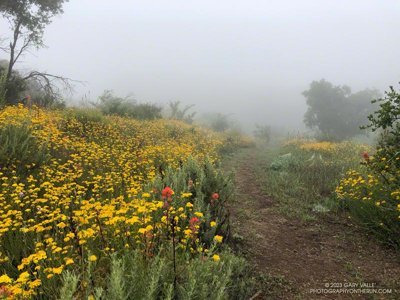
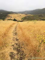
After turning onto the Serrano Valley Trail and climbing up to the overlook of Serrano Valley the trail wasn’t quite so overgrown — at least I could run. In the grasslands below the greens of the rainy season were gone, replaced with the straw-colored hues of dried grass gone to seed.

Serrano Valley
Serrano Valley

Like mustard, foxtails are bad this year. In recent weeks I’ve picked a multitude of the barbed grass seeds from my socks and shoes. Today, I’d worn ankle gaiters hoping to ward off the expected seed-storm in Serrano Valley. The seed-storm turned out to be more of a seed-shower, but the gaiters did help.

Part way through Serrano Valley I happened on a hiker, coming up from Serrano Canyon. We said hi to each other and then after he passed, he turned around and dramatically exclaimed “Don’t go down Serrano Canyon!!”

What?? Were there ogres down there? He’d obviously made it through the canyon OK. All limbs were intact and I didn’t see any cuts or bruises. I quickly ran through the possibilities and rejected most of them. One possibility that seemed plausible was that the trail had been washed out.

Covered in mustard petals after mustard-whacking on the Old Boney Trail.
Covered in mustard petals.

One of the reasons I was doing this run was to see how Serrano Canyon had fared during the February 17 atmospheric river event. I’d seen the damage caused by high flows in Blue Canyon and Upper Sycamore Canyon. This was the first chance I’d had to investigate Serrano Canyon since the flooding, so the hiker’s warning had the opposite of its intended effect — it just made me more curious about what was going on in the canyon.

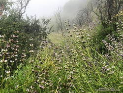
All the way down the canyon I kept an eye out for X-Files monstrosities, but saw none. Serrano Canyon did not appear to have had as severe flooding as Blue Canyon and Upper Sycamore Canyon. Some sections of the trail were very overgrown and a short section of the trail was partially washed away, but with care and a bit of mustard-whacking the trail was passable.

Canyon Sunflowers
Canyon Sunflowers

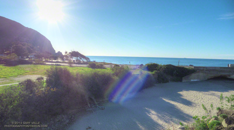
I’d had my fill of mustard and was happy to reach the dirt road in Big Sycamore Canyon. I returned up canyon using a combination of Big Sycamore Canyon Road and the Two Foxes Trail. This was much more straightforward than Old Boney and it took only about an hour to reach the Upper Sycamore Trail.

The work done on the Upper Sycamore Trail by the Santa Monica Mountains Trail Council during Trail Days was impressive. Several sections of the trail were washed away by the February 17 atmospheric river event and all have been restored.

You Can’t Run Just Part Way Up Serrano Canyon

Serrano Valley and Boney Mountain

Today’s plan was to get in around 25 miles, and like last Saturday, I was trying to keep the elevation gain down to something reasonable. I’ve been doing longer weekday runs, longer weekend runs and more days with runs. If I increased the elevation gain by the same percentage as the mileage I didn’t think I would be able to keep up with the extra training.

Today’s long run had started with a low impact 8.5 miles from Wendy Drive & Potrero road down Sycamore Canyon to the beach. That had gone well. I’d hooked up with a group training for the L.A. Marathon, and they had set a comfortable — but steady — pace.

Sycamore Canyon Campground was just beginning to stir as I ran down the access road. Warm sunlight was finding its way into the camp and other than the camp host, not many people were out and about.  Overhead a raucous gang of crows jeered a passing band of parrots, and across PCH a wave crashed on the rocky shore.


I continued running through the campground to the day use parking lot and then down onto the sand at the PCH bridge. The tide was high and from time to time whitewater from a larger wave would rush up the sand slope under the bridge and spill over the berm. I thought of bare feet on cold Rincon sand and how 55 deg water would at first feel warm on a Winter day.

With Part A of my run complete, I started thinking about Part B. If I was going to reach my mileage goal I needed to extend the return route by about 7 miles. To keep the elevation gain to a minimum, I came up with the contrived idea of doing out & backs up Serrano Canyon and Wood Canyon on the way back up Sycamore. It didn’t sound very appealing, but would add the necessary miles. Leaving the sand and seagulls behind, I started the long haul back up the canyon.

It wasn’t as cold in Sycamore Canyon as last Saturday, but with the down-canyon breeze it was still chilly in the shade. In about 15 minutes I reached the Serrano Canyon Trail and turned east up the canyon. The initial part of the canyon was quite flat and I resigned myself to the idea of running part way up the classic canyon and turning around just before reaching one of the most scenic spots in the Santa Monica Mountains.


At the landslide a half-mile into the canyon the trail steepens briefly and climbs above the creek. Just before starting up the hill I stopped to take a photo of the slide. Looking closer at one of the large boulders, I noticed it contained shell impressions and remnants similar to those found on the Fossil Trail. After snapping a photo I continued up the canyon.

Much of Serrano Canyon was in shade on this Winter morning; but in places the sun would find its way through the twists and turns of the canyon, warming me as only the morning sun can do on a cold day. With almost no water in the creek the 15 or so creek crossings in the canyon were just dips in the trail and the running was free, easy and enjoyable.

I passed the two mile turnaround point with little thought of plans, miles, races or elevation gain, and soon found myself standing on the edge of Serrano Valley’s spectacular grasslands. Rock formations on the southern flank of Boney Mountain towered above the valley and a green undercoat of Winter growth accented the trails and terrain. With a deep sigh I continued running into the Boney Mountain wilderness.

*****

I did get in my 25 miles, but not in the way I planned. From Serrano Valley I followed the Ray Miller 50K course backward, running the Serrano Valley, Old Boney, Blue Canyon, and Sin Nombre trails to the Hidden Pond Trail. There I lef the Ray Miller course and followed the Upper Sycamore Trail to Danielson Road and Satwiwa.

This route bypassed Sycamore Canyon road almost entirely and avoided the toil of having to run back up the road after just running down it. One minor issue was that when I got back to Satwiwa, I’d only run 21 miles. That was remedied by running over to Ranch Overlook and back.

Some related posts: Fossil Trail – Pt. Mugu State Park, Boney Mountain – Serrano Valley Adventure Run

A Really Overgrown Trail, Thirty Creek Crossings, and Thousands of Wildflowers

Yarrow and paintbrush along the Old Boney Trail in Pt. Mugu State Park.
Old Boney Trail in Pt. Mugu State Park.

Starting at the Wendy Drive Trailhead, I’d crossed Satwiwa, run down Danielson Road, rock-hopped across Upper Sycamore Creek, and picked up the Old Boney Trail. The condition of the Old Boney Trail between Danielson Road and the Fossil Trail junction was better than expected. Maybe the trail was going to be in good shape after all.

A section of the Old Boney Trail overgrown with black sage following the wet rain season of 2022-2023.
A section of the Old Boney Trail overgrown with black sage.

Wrong! Once I passed the turnoff to the Fossil Trail, the vegetation closed in. In places it was so thick I couldn’t see the trail at my feet, much less a few yards ahead. All I could do is smile and work my way through it. Everything was overgrown — bushes, grasses, wildflowers. And everything was wet with dew. A hundred yards past the Fossil Trail, I was soaked from head to toe.

I tried to see the positive. It was an amazing display of the effect of a wet rainy season. Without trail work and use, it wouldn’t take long for the trail to be completely consumed.

The Old Boney Trail continued to be a tangle of chaparral for about two miles — until I reached the Backbone Trail at Blue Canyon. At that point, it becomes part of the Backbone Trail system, and I was relieved to see that some work had recently been done on the trail.

Coast live oak and fog along the Old Boney Trail in Pt. Mugu State Park.
Coast live oak along the Old Boney Trail.

As I worked up the Backbone Trail toward the Chamberlain Trail junction, I recalled other times I’d run to Serrano Valley using Old Boney. What would the condition of the trail be beyond this point? I’d been on that part of the Old Boney Trail following a wet rain season and knew how overgrown it could be. Some refer to that section of trail as “tick alley.”

But when I got to the junction, surprise, surprise, the Old Boney Trail had been trimmed. More than two miles of trail were groomed. It was good all the way to the Serrano Valley Trail and partway into Serrano Valley. The trail in Serrano Valley was a little overgrown, but NOTHING like the Old Boney Trail between the Fossil and Backbone Trails.

Part of the fun of doing this route is all the stream crossings in Serrano Canyon — what is it 13 or 14? Today, most of these could be done without getting your shoes wet — especially if you have poles. I didn’t have poles, and my shoes and socks were already wet, so I didn’t worry about keeping them dry. Some sections of the Serrano Canyon Trail were also overgrown, but not bad. However, there was a lot of poison oak, some of which wasn’t avoidable.

Paintbrush and golden yarrow along Sycamore Canyon Fire Road in Pt. Mugu State Park.
Paintbrush and golden yarrow

After getting a drink of water at the faucet at the junction of the Serrano Canyon Trail and Sycamore Canyon Fire Road, I headed up-canyon. Almost immediately, the fire road crossed Big Sycamore Canyon Creek. I did this first crossing without getting my shoes wet, but nine more crossings followed, and most resulted in soaked shoes. The water crossings and wildflowers helped distract me from the five mile run up Sycamore Canyon to the Upper Sycamore Trail.

Getting off Sycamore Canyon Road and onto the Upper Sycamore Trail was a relief. Whatever run I do from Wendy Drive, I always finish it via this trail. The trail gets enough use that it was in good shape. This time all the creek crossings could easily be rock-hopped.

Even with a few tedious sections, it was an adventurous and mostly enjoyable 20 miles. Here are some photos taken along the way.

Some related posts: Old Boney to Serrano Valley, Plus Fireline and Overlook; Looking for Ogres in Serrano Canyon; Running to Serrano and La Jolla Valleys from Wendy Drive; You Can’t Run Just Part Way Up Serrano Canyon

Not So Busy Sandstone Peak

Boney Mountain area peaks from the top of Sandstone Peak.

With the closure of Los Padres, Angeles, San Bernardino, and Cleveland National Forests until Thursday, I did not expect to find the summit of the highest peak in the Santa Monica Mountains empty. Even if it was by happenstance, I’ve rarely found the summit of Sandstone unoccupied on a Saturday or Sunday morning.

Like last weekend’s run, this morning’s trail run started at the Wendy Drive Trailhead on Potrero Road in Newbury Park. But today’s route had a lot more elevation gain, and some steep scrambling up the rocks of Boney Mountain’s Western Ridge. It’s an adventurous way to do Boney Mountain, Tri Peaks, and Sandstone Peak, and get in some excellent running on a very scenic stretch of the Backbone Trail.

Overall, the route was in the best shape I’ve seen since the 2018 Woolsey Fire. The path that works up the north side of Tri Peaks and around the east side of its summit blocks was relatively clear. Following trailwork by the Santa Monica Mountains Trails Council, the Chamberlain Trail segment of the Backbone Trail was once again an enjoyable downhill run.

Here’s an interactive, 3D terrain view of a GPS trace of my usual route (yellow) to Sandstone Peak from Wendy Drive via Boney Mountain’s Western Ridge, and return via Big Sycamore Canyon. A GPS track of the Cabin trail is also shown. Variations of the route include doing the Mishe Mokwa loop after climbing Sandstone Peak; and returning to Sycamore Canyon via Serrano Valley/Canyon instead of Blue Canyon.

Some related posts: Sandstone Peak from Wendy Drive, Over Boney Mountain to Sandstone Peak and Serrano Valley, An End of Year Boney Mountain Adventure, Too Many Flowers on the Chamberlain Trail

A Windy Run, Walk, Ride, for Wildlife Research

Boney Mountain and Serrano Valley from Overlook Fire Road
Boney Mountain and Serrano Valley from Overlook Fire Road.

The Overlook Fire Road in Pt. Mugu State Park was nearly empty. I’d seen only two hikers between the top of the Fireline Trail and the top of the Wood Canyon Vista Trail. Maybe it was the wind. There had been 20-25 mph wind gusts much of the morning. Along the ridgelines, the gusts were even stronger.

Run, Walk, Ride 2020

I’d picked Pt. Mugu State Park to do a run in support of the Santa Monica Mountains Fund’s Run, Walk, Ride, for Wildlife Research. Many mountain lions have included Pt. Mugu State Park in their home range, including P-1, the patriarch of the mountain lions in the Santa Monica Mountains study.

According to the NPS website, the Santa Monica Mountains National Recreation Area is the world’s largest urban national park. Wildlife in the Park is affected by issues resulting from the proximity of urban and wild areas. Among the problems are poisoning from anticoagulant rodenticides, limited genetic diversity, and vehicular deaths. Only by studying Park wildlife can we better understand and manage these and other issues.

Because water is usually available at several spots in Sycamore Canyon, it’s a great place to do a self-supported ultra-length trail run.

A very windy Pacific and the Ray Miller segment of the Backbone Trail
A very windy Pacific

So far, today’s run had taken me from Wendy Drive in Newbury Park to Serrano Valley via the Old Boney Trail. I’d circled past the old ranch in Serrano Valley and then descended the Serrano Canyon Trail to Sycamore Canyon. A short jog south in Sycamore Canyon put me at the bottom of the Fireline Trail, which I’d followed up to the Overlook fire road.

Next up was a scenic loop in La Jolla Valley. After that, I would work my way back to the Upper Sycamore Trail via Sycamore Canyon. From there, it would only be a few miles back to the Wendy Drive Trailhead.

The Santa Mountain Mountains Trails Council has been hard at work. Even though they can’t currently accept volunteer assistance, it looked like the Old Boney, Serrano Canyon, and Upper Sycamore Trails had been recently maintained.

Some related posts: It’s Raining Mountain Lion Tracks!; Mountain Lion Tracks on Rocky Peak Road; Mountain Lion Saga; Reagan Ranch Bobcat; Hawk, Bobcat and Rabbit