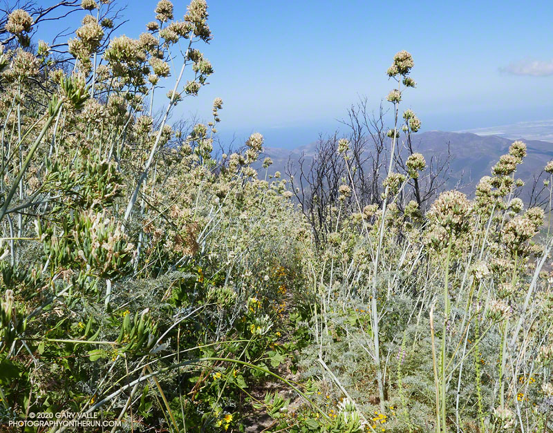
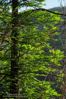
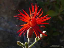
Flower stalks of bleeding heart on the Chamberlain segment of the Backbone Trail
After climbing the western ridge route on Boney Mountain and scrambling over Tri Peaks, I was trying to run down the Chamberlain segment of the Backbone Trail. Usually one of my favorite downhills, the trail was so glutted with the flower stalks of bleeding heart, it made running difficult. Here’s a video snapshot of one short section of trail.
During this second Spring following the Woolsey Fire, bleeding heart has become a predominant fire follower in the Boney Mountain Wilderness. Its rampant growth is reminiscent of the explosion of Poodle-dog bush in the San Gabriel Mountains the second Spring following the 2009 Station Fire.
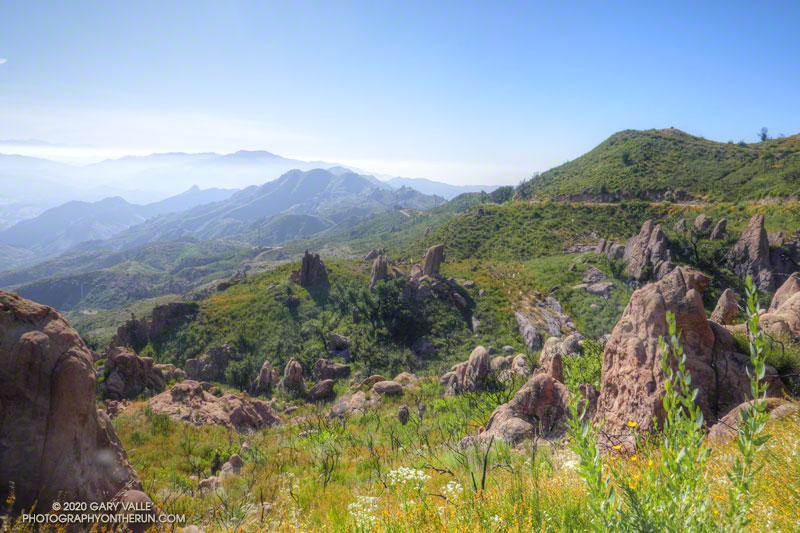
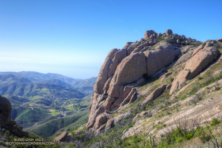
View east of the Santa Monica Mountains from near the top of the Bulldog fire road.
With the reopening of trails in the Santa Monica Mountains, my list of “must do” trails is impossibly long. Today, I headed over to Malibu Creek State Park to do a variation of the popular Bulldog Loop, and catch-up on what was happening in the Park as it recovers from the Woolsey Fire.
The route I was running starts at the Cistern Trail trailhead on Mulholland and descends to Crags Road using the Lookout and Cage Creek Trails. After a side trip on the Forest Trail to see the coast redwoods, it continues counterclockwise around the regular Bulldog Loop. Here’s an interactive, 3D view of the approximately 17-mile variation of the Bulldog Loop.
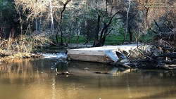
Crossing Malibu Creek
Summer 2022 Update. A seasonal bridge has been installed across Malibu Creek at the site of the original bridge. The bridge is removed when there is a threat of flooding on Malibu Creek. This is typically during the rainy season.
As I ran along Crags Road toward the M*A*S*H site, I wondered how much water would be in Malibu Creek, and if the fallen tree used to cross the creek would still be there.
Washed-out footbridge on Malibu Creek
Since February 2019, hikers, runners, and riders doing the Bulldog Loop or headed to the M*A*S*H site have had to either get their feet wet or use a fallen tree to cross Malibu Creek. The concrete slab bridge is still there, but the stream now flows around the bridge, rendering it useless.
The bridge survived a canyon-wide flood in mid-February 2017. But two years later, and just 11 weeks after the Woolsey Fire, sediment-laden runoff from burned hillsides clogged the drainage pipes embedded in the bridge’s concrete slab. With nowhere to go, the stream simply circumvented the structure.
Nearly to the bridge, I turned right off of Crags Road and followed the well-trodden path along the creek for about 70 yards. The downed tree had not washed away. Not wanting to take an early morning bath, I carefully worked across the logs and limbs and then rejoined the Crags Road Trail, near a coast redwood.
Checking on the Malibu Creek State Park Redwoods
Whenever I do the Bulldog Loop, I usually stop by the Forest Trail and see how the 100+ year-old coast redwoods are doing. Several of the 16 or so redwoods were killed by the 2011-2015 drought, and virtually all the trees were scorched in the Woolsey fire.
New growth on a young redwood burned in the Woolsey Fire
I’d last checked on the redwoods at Christmas and had been encouraged by the condition of the remaining trees. In Los Angeles, three of the past four rain years have recorded average or above-average rainfall. This seems to have really helped the surviving redwoods.
There are five or six trees that are doing well. They’ve added a lot of new foliage and look healthy. I was excited to see that a young, naturally-germinated redwood was thriving. It was burned in the Woolsey Fire and lost most of its foliage.
Leaving the redwoods behind, I continued toward the M*A*S*H site and then up the Bulldog climb.
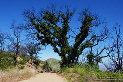
As I worked up the Bulldog fire road, I marveled at the number of live oaks sprouting new foliage on their burned trunks and limbs. On Mesa Peak Mtwy fire road, there is a grove of live oaks that used to provide welcome relief from the blazing-hot summer sun. On the crest of a ridge, the trees must have been fully-engulfed in fire when burned during Woolsey Fire. None the less, the trees are recovering. Compare this December 2018 photo of one of the larger live oaks, to what it looks like today. Incredible!
Digger Bees
Cruising along Mesa Peak Mtwy fire road, I took an auditory double-take. What the heck was all the buzzing around me? That’s when I realized the loud, resonate buzz was from thousands and thousands of bees. I’d just run into a huge aggregation of digger bees.
Digger bees along Mesa Peak Mtwy fire road
I’ve encountered them before. Even though the males (reportedly) don’t have a stinger and the females (reportedly) aren’t usually aggressive, it was a little unnerving walking through so many active bees. Here’s a video snapshot of the digger bees on Mesa Peak fire road.
Digger bees are not social in the same way as honeybees. Female digger bees build their individual brood cells in a communal area to efficiently reproduce. According to behavioral ecologist John Alcock, the males emerge slightly before the females and then fly low over the area, searching for females that are about to emerge. Using their antennae, the males can find the females in a burrow, before they emerge, gaining a competitive edge. For more info, see the article Desert Diggers, in Arizona State University School of Life Sciences’ Ask A Biologist web site.
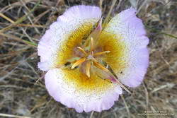
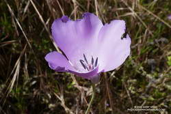
Splendid Mariposa and Other Wildflowers
Splendid mariposa lily
At first I ran past it. I was descending the Tapia Spur Trail and nearly to the gravel parking lot in Malibu Creek State Park when a flash of purple caught my eye. My thought was that it was a solitary farewell-to-spring (Clarkia). But something didn’t seem right, and it would be unusual to see just one farewell-to-spring. So I went back to take a look, and it turned out to be a splendid mariposa lily (Calochortus splendens). Although it is common in areas south of Los Angeles, it is the first I have photographed in the Santa Monica Mountains. This one was not quite so splendid as it might have been since a beetle had been feasting on its petals.
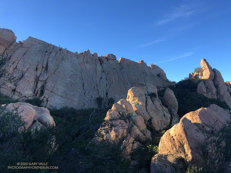
Along with Sandstone Peak, Tri Peaks, and Exchange Peak, Boney Peak is an officially named peak that is part of the Boney Mountain massif. The peak is located about 0.5 mile southwest of Sandstone Peak and is easily accessed from the Backbone Trail.
I’d climbed the other peaks in the area, and run past Boney Peak many times, but never scrambled to its summit. Getting to Boney Peak from the Wendy Drive trailhead was pretty much the same as doing Sandstone Peak. I took the “escalator” up the Western Ridge of Boney Mountain to Peak 2935 and then ran over to Tri Peaks. From there, I followed the Tri Peaks Trail to the Backbone Trail, near the Mishe Mokwa Trail junction.
Tri Peaks from the top of Boney Peak
The use trail to the top of Boney Peak leaves the Backbone Trail about a mile from the Tri Peaks/Mishe Mokwa Trail junctions. Other than a little brush, it’s fairly easy to get to the peak’s boulder-strewn summit. There was a red register can stashed in the rocks. (The title photo of Boney Peak was taken where the use trail begins.)
The actual high point of the peak is atop, a large, exposed summit block. Various trip reports describe the easiest route up the summit block as class 3. That seems about right. Although relatively straightforward, the use of handholds is necessary, and a fall would ruin your whole day. Like many such boulders, it is easier to climb up than to climb down, and someone without rock climbing experience could easily find themselves unable or unwilling to climb down.
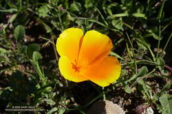
California poppy blooming in February!
From Boney Peak, I returned to the Backbone Trail and headed west, down the Chamberlain Trail and on to the Danielson Multi-Use area. A few brightly-colored, yellow-orange poppies were already blooming along the trail. The rest of the run was the usual jog up Sycamore Canyon to the Upper Sycamore Trail, and then back to Satwiwa and Wendy Drive.
Here’s a 3D Cesium interactive view that shows a GPS track of my route. The view can be zoomed, tilted, rotated, and panned. Placemark and track locations are approximate and subject to errors.
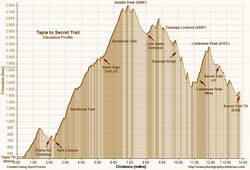
The range of temperatures had been remarkable. At the Secret Trail trailhead in Calabasas, where I left my car, it had been a balmy 60 degrees. Near the start of my run from the Tapia Trailhead in Malibu Canyon, it had been a very chilly 32 °F. Near the end of the run, the temp topped out at 79 °F. That’s SoCal Winter running!
On the way to Saddle Peak, I was surprised to see how wet it was on some sections of the Backbone Trail. There has been very little rain this January, but marine layer dew, the trail’s north-facing aspect, the low sun angle, the canopy of bays and oaks, and relatively cool temps have kept the trail damp. In places it looked like it had just rained yesterday.
Elevation profile for trail run from Tapia to Secret Trail via Topanga Lookout and Ridge.
Because there’s about 1000′ less elevation gain, I usually do this run in the opposite direction, starting on the Secret Trail and ending at Tapia. This is the route described in the venerable guidebook, 50 Trail Runs in Southern California. But I’d run it in that direction a bunch of times — so here I was, chugging up the Backbone Trail, nearing the end of a 2600′, seven-mile climb from Tapia to Saddle Peak.
The area around Saddle Peak is yet another spectacular section of the Backbone Trail. (There are so many!) Just west of the peak, the trail winds through a narrow passage with massive sandstone rocks on either side. As the trail levels out, there is a short spur trail to the peak’s antennae-infested summit.
Even if a little obstructed, views from the top extend to Catalina, Boney Mountain, Mt. Pinos, and Mt. Baldy. Sometimes San Gorgonio Mountain and San Jacinto Peak can be seen beyond Mt. Baldy. The round trip to the summit of Saddle Peak adds about 0.8 mile. The eastern summit is slightly lower, but no antennae obstruct the view.
Getting to Saddle Peak from the Tapia trailhead is relatively straightforward, if a bit strenuous. Getting to Calabasas Peak and the Secret Trail from Saddle Peak is not as simple.
The “normal” way to get from Saddle Peak to Calabasas Peak would be to run back down the Backbone Trail to the Stunt High Trail and then follow that trail to the parking area on Stunt Road. Calabasas Peak Mtwy is across the highway and slightly downhill (west) of the parking area and leads to Calabasas Peak and the Secret Trail.
If doing the regular route, note that the Stunt High Trail crosses Stunt Road twice on the way down. In each case turn right and follow the road east about 100 yards to pick up the trail on the other side of the road. There are also various side trails to avoid.
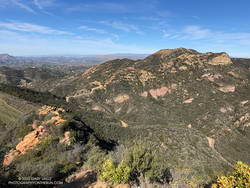
Calabasas Peak from Topanga Lookout Ridge.
I had been planning to do the regular route, but as I was returning to the Backbone Trail from Saddle Peak, it occurred to me there was a way to avoid backtracking. Instead of turning left on the Backbone Trail and descending to the Stunt High Trail, I turned right and continued east, past the water tank, to the Lois Ewen Overlook. From there, I ran over to the Topanga Lookout and then scrambled down Topanga Lookout Ridge to Calabasas Peak Mtwy.
This option is more adventurous, but requires good route-finding skills and being comfortable clambering down a rocky ridge. This 3D Cesium interactive view shows a GPS track of my route. The yellow track is today’s route. The red track is the usual route between the Backbone Trail and Calabasas Peak Mtwy. The view can be zoomed, tilted, rotated and panned. Placemark and track locations are approximate and subject to errors.
Scrambling down the ridge put me at “The Bench,” at the junction of Calabasas Peak Mtwy and Red Rock Road. This is a little more than a mile from Calabasas Peak. Once on Calabasas Peak, it was only about 0.6 mile to the top of the Secret Trail, and from there about 1.3 miles of mostly downhill running to the trailhead.
With about 4000′ of gain over 14 miles, it was a demanding route, with challenging route-finding and a fun scramble down a rocky ridge. Here are a few photos taken along the way.
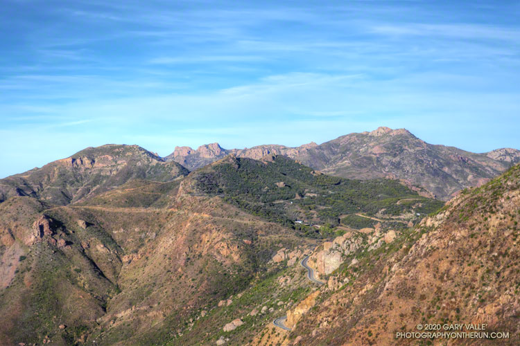
Backbone Trail, Triunfo Lookout, Boney Mountain, and Sandstone Peak from Etz Meloy Mtwy
Several segments of the Backbone Trail are spectacular and have superb scenery, but one of my favorites is the stretch between the Encinal Canyon and Mishe Mokwa Trailheads. Accentuated by dramatic rock faces and outcrops, expansive mountain views are at every turn.
Done as an out and back run, the 21-mile route has a modest 2500′ of elevation gain. This translates to a relatively moderate and runnable course with more than 18 miles of single-track.
I had not run this stretch since the Woolsey Fire ravaged the Simi Hills and western Santa Monica Mountains, a little more than a year ago. While I was discouraged to see the burned limbs of what had been 8′-12′ tall red shanks, it was heartening to see that the area was recovering, and was no longer a barren and blackened “moonscape.”
If you look at the traditional USGS 7.5 minute Triunfo Pass and Newbury Park topographic maps, BONEY MOUNTAIN refers to the large, mountainous plateau that extends roughly from Peak 2417 on the west; to Peak 2793 on the north; and to Sandstone Peak on the east. However, when people say they are climbing “Boney Mountain,” they are usually referring to a high point north of Tri Peaks, on the northwest corner of the plateau, above Newbury Park. This illustration shows these features.
This high point has an elevation of about 2935′ and is typically reached by ascending the Upper Cabin Trail or Western Ridge route. When climbing to this point, most start at one of the Satwiwa trailheads, such as at Wendy Drive and Potrero Road. The high point is NOT the same as “Boney Peak,” which on recent maps is ascribed to a peak adjacent to Inspiration Point, and has an elevation of about 2825′.
Today’s running adventure ascended the Western Ridge route to point 2935 and then worked over to the Backbone Trail, by way of Tri Peaks. Part of today’s adventure was to investigate a peak near the top of the Chamberlain Trail that is labeled peak 2880 on traditional topo maps, but is labeled “Boney Mountain” on many online, GIS-based maps.
The traditional, hand-crafted USGS 7.5 minute topographic maps were produced from about 1945 to 1992, with map revisions continuing until 2006. These maps are now part of the USGS Historical Topographic Map Collection (HTMC) and still widely used. The intended replacements are the GIS-based “US Topo” maps, first released in 2012. The USGS topoView application can be used to view historical and current USGS topo maps.
The USGS “US Topo” maps are digitally produced from GIS data. As a result, some features traditionally included in USGS topographic maps — such as trails, landmarks, buildings and recreational features — may not be included. It also appears there have been some issues with geocoding placenames.
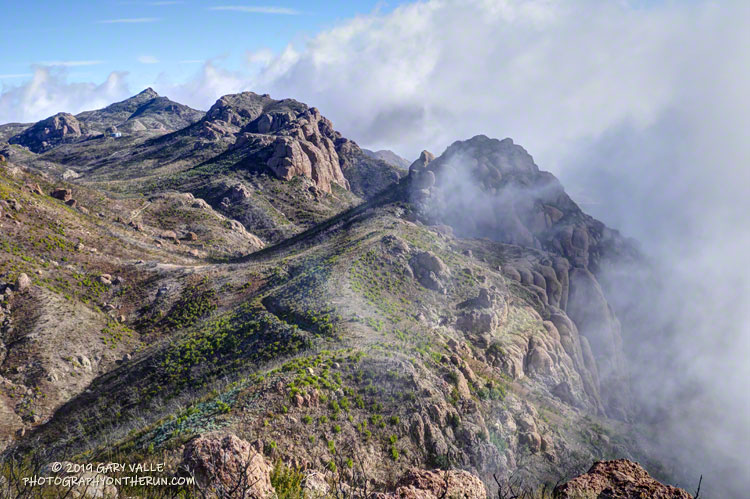
The conditions for today’s run were fantastic. Wind-driven clouds condensed along Boney Mountain’s western escarpment, spilling and tumbling over its edge in dramatic fashion.
Clouds spilling over the lip of Boney Mountain’s western escarpment.
As for the other Boney Mountain — Peak 2880 — it was brushy and the rock wasn’t the best, but climbing it did provide some fresh views of the Boney Mountain area. My guess is that the “BONEY MOUNTAIN” label, which described an area on the traditional maps, was treated like a point feature when geocoded. The nearest point happened to be Peak 2880, which speciously became “Boney Mountain.”
In the 2018 edition of the Triunfo Pass US Topo, the Boney Mountain label was moved to Tri Peaks, and the label for Tri Peaks was moved to another, unnamed, peak. In the current online version of the map, the Boney Mountain label and Tri Peaks label are at Tri Peaks. Over time the maps should improve, but until then, I’ll continue to use the traditional 7.5 minute USGS maps, or commercially produced maps that have been field verified.
And what about point 2935 – the high point on the crest that so many people climb? It really deserves a name. Given it overlooks the Danielson Monument and cabin site, maybe something like “Danielson Peak” would be fitting.