Category Archives: running|adventures

Red Box – Bear Canyon – Switzer’s Loop – Memorial Day Weekend 2023

Marine layer pushing into Bear Canyon in the San Gabriel Mountains, near Los Angeles.
Marine layer pushing into Bear Canyon

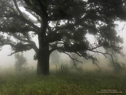
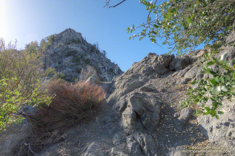
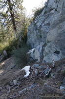
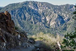
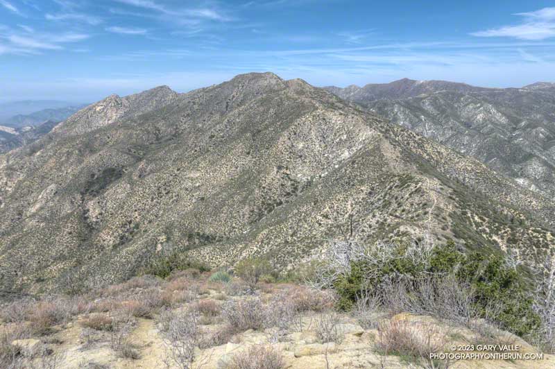
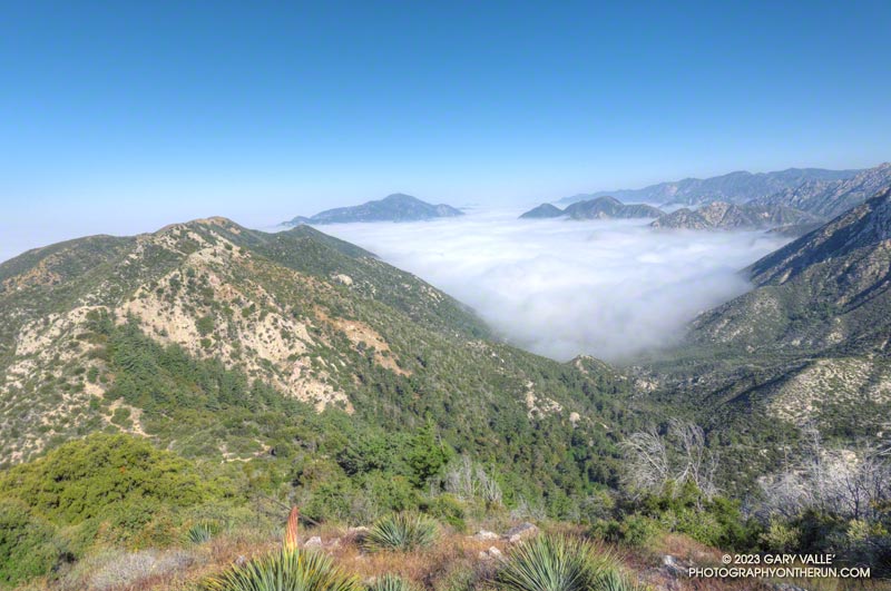
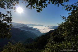
The Red Box – Bear Canyon – Switzer’s Loop trail run is a favorite I’ve enjoyed doing for many years. Part of its attraction is the isolated, backcountry feel of Bear Canyon, particularly between Tom Sloane Saddle and Bear Canyon Trail Camp. It’s worth spending a few minutes at the old cabin site in the upper canyon to contemplate a lifestyle from an earlier century.

Early morning view from the Bill Reily Trail (aka Mt. Disappointment Trail).
Early morning view from the Bill Riley Trail (aka Mt. Disappointment Trail).

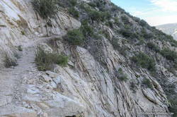
The descent of Bear Canyon is always adventurous in some way. Based on what I’d been seeing on other trails this year, I’d expected upper Bear Canyon to be a mess. I had braced myself for downed trees, washouts, and overgrown, hard-to-follow sections of trail.

But just a few minutes below Tom Sloane Saddle, a tree blocking the trail had been cleared, and the saw cuts were fresh! As I worked down the trail, I was excited to find more trailwork had been done. Branches or trees that had fallen across the trail had been cut. Some overgrown sections of trail had been trimmed. One washed-out section of trail looked like it had just been repaired. Someone had even trimmed a little of the poison oak that is so common along the trail.

Bear Canyon Trail near Arroyo Seco

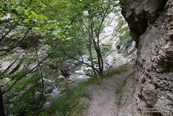
As I discovered when I encountered them lower in the canyon, the Bear Canyon Trail Crew had been hard at work, and they were working in the canyon again today!

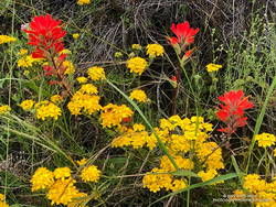
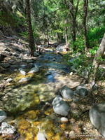
The last time I was in Bear Canyon (April 2021), the creek had been nearly dry. This year there was plenty of water and plenty of stream crossings. Unlike several recent runs, I had my poles and was able to keep my shoes and socks mostly dry.

Trailside wildflower garden on the Bear Canyon Trail.
Trailside wildflower garden

I had debated whether to do this loop on Memorial Day Weekend. It passes through Switzer’s Picnic Area, one of the most popular day-use areas in Angeles National Forest. Many visiting Switzer’s do the hike down the Gabrielino Trail to see Switzer Falls, and many of those continue down the Bear Canyon Trail to the area below the falls.

Today, the two-mile stretch from below the falls to Switzer’s was as busy as expected. One issue I hadn’t anticipated was that some stream crossings were backed up like the Hillary Step on Everest. Other than wading, there was usually only one “dry” route across the stream. At one busy crossing, a hiker — clutching a dog under each arm — deftly balanced across a sequence of slippery rocks and branches, keeping his and his charge’s feet dry.

Crimson-spotted rock rose along the Gabrielino Trail between Switzer's and Red Box
Crimson-spotted rock rose along the Gabrielino Trail

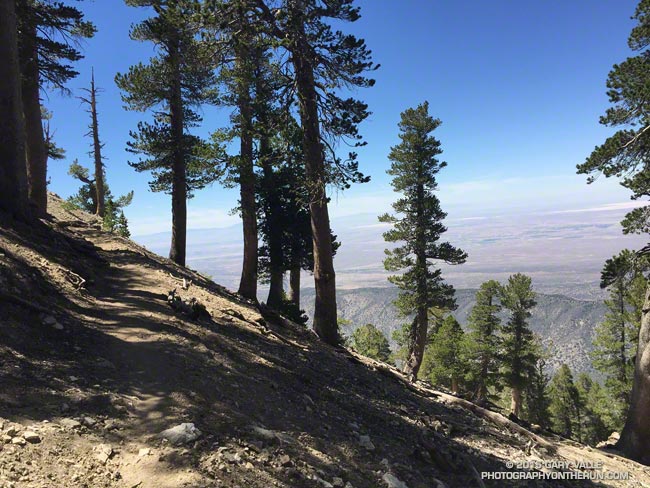
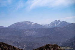
Once past Switzer’s, things returned to normal. From Switzer’s, it’s about 4.5 miles up to Red Box, with an elevation gain of about 1350′. I had been on this section of the Gabrielino Trail about a month before and was curious to see if a mass of fallen trees blocking the trail had been removed.

The trees still needed to be cleared — Forest Service rules require a qualified sawyer to do that kind of work — BUT the remaining 2.5 miles of trail to Red Box were being trimmed and cleared by several dozen members of the Mt. Wilson Bicycling Association. I wondered why I wasn’t seeing any mountain bikers on the trail — they were all working on it!

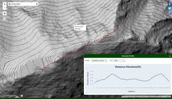
Here’s an interactive, 3D terrain view of the Red Box – Bear Canyon – Switzer’s Loop. The map can be zoomed, tilted, rotated, and panned. To change the view, use the control on the upper right side of the screen. Track and placename locations are approximate and subject to errors.

Some related posts: Bear Canyon Loop – 2021, Red Box – Bear Canyon Loop Plus Brown Mountain, Bear Canyon Loop Plus Strawberry Peak

Canyon liveforever (Dudleya cymosa) in Bear Canyon.
Canyon liveforever.
Paintbrush along the Gabrielino Trail between Switzer's and Red Box.
Paintbrush along the Gabrielino Trail.

A Really Overgrown Trail, Thirty Creek Crossings, and Thousands of Wildflowers

Yarrow and paintbrush along the Old Boney Trail in Pt. Mugu State Park.
Old Boney Trail in Pt. Mugu State Park.

Starting at the Wendy Drive Trailhead, I’d crossed Satwiwa, run down Danielson Road, rock-hopped across Upper Sycamore Creek, and picked up the Old Boney Trail. The condition of the Old Boney Trail between Danielson Road and the Fossil Trail junction was better than expected. Maybe the trail was going to be in good shape after all.

A section of the Old Boney Trail overgrown with black sage following the wet rain season of 2022-2023.
A section of the Old Boney Trail overgrown with black sage.

Wrong! Once I passed the turnoff to the Fossil Trail, the vegetation closed in. In places it was so thick I couldn’t see the trail at my feet, much less a few yards ahead. All I could do is smile and work my way through it. Everything was overgrown — bushes, grasses, wildflowers. And everything was wet with dew. A hundred yards past the Fossil Trail, I was soaked from head to toe.

I tried to see the positive. It was an amazing display of the effect of a wet rainy season. Without trail work and use, it wouldn’t take long for the trail to be completely consumed.

The Old Boney Trail continued to be a tangle of chaparral for about two miles — until I reached the Backbone Trail at Blue Canyon. At that point, it becomes part of the Backbone Trail system, and I was relieved to see that some work had recently been done on the trail.

Coast live oak and fog along the Old Boney Trail in Pt. Mugu State Park.
Coast live oak along the Old Boney Trail.

As I worked up the Backbone Trail toward the Chamberlain Trail junction, I recalled other times I’d run to Serrano Valley using Old Boney. What would the condition of the trail be beyond this point? I’d been on that part of the Old Boney Trail following a wet rain season and knew how overgrown it could be. Some refer to that section of trail as “tick alley.”

But when I got to the junction, surprise, surprise, the Old Boney Trail had been trimmed. More than two miles of trail were groomed. It was good all the way to the Serrano Valley Trail and partway into Serrano Valley. The trail in Serrano Valley was a little overgrown, but NOTHING like the Old Boney Trail between the Fossil and Backbone Trails.

Part of the fun of doing this route is all the stream crossings in Serrano Canyon — what is it 13 or 14? Today, most of these could be done without getting your shoes wet — especially if you have poles. I didn’t have poles, and my shoes and socks were already wet, so I didn’t worry about keeping them dry. Some sections of the Serrano Canyon Trail were also overgrown, but not bad. However, there was a lot of poison oak, some of which wasn’t avoidable.

Paintbrush and golden yarrow along Sycamore Canyon Fire Road in Pt. Mugu State Park.
Paintbrush and golden yarrow

After getting a drink of water at the faucet at the junction of the Serrano Canyon Trail and Sycamore Canyon Fire Road, I headed up-canyon. Almost immediately, the fire road crossed Big Sycamore Canyon Creek. I did this first crossing without getting my shoes wet, but nine more crossings followed, and most resulted in soaked shoes. The water crossings and wildflowers helped distract me from the five mile run up Sycamore Canyon to the Upper Sycamore Trail.

Getting off Sycamore Canyon Road and onto the Upper Sycamore Trail was a relief. Whatever run I do from Wendy Drive, I always finish it via this trail. The trail gets enough use that it was in good shape. This time all the creek crossings could easily be rock-hopped.

Even with a few tedious sections, it was an adventurous and mostly enjoyable 20 miles. Here are some photos taken along the way.

Some related posts: Old Boney to Serrano Valley, Plus Fireline and Overlook; Looking for Ogres in Serrano Canyon; Running to Serrano and La Jolla Valleys from Wendy Drive; You Can’t Run Just Part Way Up Serrano Canyon

The Ups and Downs of the Angeles Crest 100 Mile Run

Pacific Crest Trail on Mt. Baden-Powell

First published on June 30, 2015. Updated June 8, 2023.

June 15, 2023. According to the AC100 website the 2023 Angeles Crest 100 Mile Run has been cancelled. According to R.D. Ken Hamada, CalTrans engineers do not expect Highway 2 to open until this Winter, at the earliest.  The section from Islip Saddle to Grassy Hollow could be closed even longer.

July 29th will mark the 34th time runners from near and far gather in a small parking lot in Wrightwood, California, to start the Angeles Crest 100 Mile Endurance Run (AC100). Begun in 1986, the AC100 is one of the original five 100-mile U.S. endurance races. It has endured fires, floods, the Covid-19 pandemic, and changing trail restrictions.

There’s a tradition of running grueling endurance races in the San Gabriel Mountains. The Big Pines Trail Marathon was one of the first organized mountain ultramarathons in the U.S. First run in August 1934, its course used some of the same trails that AC100 runners enjoy today.

The AC100 is not like a road marathon. It is an entirely different kind of running event and an entirely different kind of running experience. In 2023 the L.A. Marathon had about 22,000 participants. About 1/100th of that number — around 250 runners — are expected to start the AC100.

Sunrise from Blue Ridge during the 2015 Angeles Crest 100.
Sunrise from Blue Ridge during the 2015 AC100.

For many, one of the primary reasons for running the AC100 is to be fully immersed in the beauty and majesty of the San Gabriel Mountains. Runners start at 5:00 a.m., ascend the Acorn Trail, and as the sun rises, find themselves above 8000′, reveling in the spectacular views from Blue Ridge.

Even at this early stage of the race, the field is already becoming dispersed. By the time runners reach the first checkpoint, nine miles into the run, there is an hour spread between the first and last runners. Unlike a road marathon, much of the time a runner in the AC100 will be alone.

This year’s course returns to a point-to-point format, ending in Altadena. Because of damage to the Chantry Flat area by the Bobcat Fire, runners will bypass Chantry and ascend Mt. Wilson via the Kenyon-Devore Trail, returning to the traditional course at the Mt. Wilson Toll Road above Idlehour.

As a result of this Winter’s frequent storms, many trails have been damaged or blocked by trees and debris. Ultrarunners not only spend many hours enjoying the trails in our local mountains but also do hours of trailwork that helps keep trails open and in usable condition.

Once again this year, some long stretches of the AC100 course will be run on Angeles Crest Highway. As was done for the Western State 100 Mile course, AC100 organizers have been trying to obtain an exception to use trails historically included in the event. You can help get runners off the highway and back on the trail — for more information, see the Save the AC100 page on the AC100 website.

The elevation profile for the 2023 AC100 course (PDF) was created in SportTracks from the GPX file on the AC100 website on 6/8/23. The elevation profile was corrected using 3DEP 1-meter Lidar-based DEMs. A conservative elevation data smoothing setting was used, resulting in an estimated cumulative gain of about 17,890′ and loss of 22,550′. The actual gain and loss are probably a bit more. Placemark locations, mileages, and elevation gains and losses are approximate.

Estimated Angeles Crest 100 Mile Elevation Profile (link)
Click to view/download PDF of the elevation profile.

In addition, here is an interactive, 3D terrain map of the 2023 Angeles Crest 100 Mile Race. It is based on the course GPX file downloaded from the AC100 website. The map is initially zoomed in on the climb up Mt. Baden-Powell. To change the view, use the control on the upper right side of the screen. Track and placename locations are approximate and subject to errors.

Click to view 2023 AC100 course with photographic 3D terrain.

See the AC100 website for official information and details.

Strawberry Peak Summit Loop – Spring 2023 Update

The northwest ridge of Strawberry Peak just before the Class 2-3 rock climbing segment.

Usually, I prefer to start the Strawberry Peak Summit Loop at the Colby Canyon Trailhead on Angeles Crest Highway. But it had been a while since I’d done the loop from Clear Creek, and I was feeling a little nostalgic. One of the aid stations for the ANFTR/Mt. Disappointment race is at Clear Creek, and the course climbs Josephine Fire Road.

I was also curious how my time to Josephine Saddle using the fire road would compare to the direct route up the Colby Canyon Trail. As it turned out, at a moderate pace it was about the same either way.

Foliated rock along the use trail to the northwest ridge of Strawberry Peak

The use trail up from Josephine Saddle was in decent condition. It looked like it may have recently had a snip here and there. Part way up the path, an outcrop on the ridgeline provides a good warmup for the climbing higher up. The circuitous path eventually ends at the base of the steep, jumbled northwest ridge of Strawberry Peak. I was surprised to find two small patches of snow here.

It’s difficult to describe the route on the ridge since there are many variations. It’s not fear-mongering to say that people get into trouble on this section. A common comment about this segment is, “Don’t climb anything sketchy or difficult.” But what is an easy scramble for one person may be nearly impossible for another. With 50+ years of rock climbing experience, I still remind myself not to climb up anything I’m not 100% sure I can climb down. If you don’t have “real” rock climbing experience, go with someone that knows the route.

Snow on the NW side of Strawberry Peak on April 30, 2023.
Small patches of snow on the NW side of Strawberry Peak on April 30, 2023.

Following a wet, snowy, cold Winter, I took extra care while climbing. Solid holds and blocks can sometimes be loosened over the Winter and fail unexpectedly. This morning, I didn’t notice any obvious changes on the route I climbed.

The setting changes dramatically on the east side of Strawberry Peak. You go from the cool shadows of a steep, rocky face with (typically) no one around to a sunny, sandy, busy summit and trail.

As I approached the summit, a couple of people were setting up to do a video for a vlog. Another person had just reached the top, and another hiker wasn’t far behind. With snow in the high country, Hwy 2 still closed at Red Box, and the Bobcat Fire Closure still in effect, the trail up Strawberry was a popular option. The question of the day from the people coming up was, “How many false summits are there?”

Looking across the canyon to the Gabrielino Trail below Red Box, and Supercloud Canyon

Overall, the Strawberry Peak Trail was in reasonable shape. The trail needed a little work in a few places, but as far as mountain trails go, its condition was about what you would expect. In several places, the trail was carpeted with the remnants of old yucca leaves. Very nice!

Just before reaching Red Box, I snapped a photo of the snow on Mt. Baldy. At Red Box, all but one parking space was taken, and that one was snagged by an arriving car.

As I started down the Gabrielino Trail from Red Box, LASD Air Rescue 5 began to orbit overhead. Apparently, there had been yet another vehicle accident on Angeles Crest Highway. It wasn’t long until I heard the whaling sound of sirens coming up the canyon.

Upper Arroyo Seco at Switzer's Picnic Area.
Upper Arroyo Seco at Switzer’s Picnic Area.

Some trailwork had been done on the upper half of Gabrielino Trail between Red Box and Switzer’s. Quite a few small trees and limbs had been removed from the trail, and the bushes trimmed. Most of the work (as of today) ended at mass of fallen trees halfway down the trail.

Upper Arroyo Seco was flowing. The sound of water plunging over the debris dams made the flow seem higher than it was. There were a couple of minor creek crossings.

Switzer’s was busy — as usual. To finish the loop, I walked up the stairs to the access road and hiked up to the start of Nature’s Canteen Trail. It was a bit overgrown, but I was back at Clear Creek in a few minutes.

Some related posts: Strawberry Peak Summit Loop; Plan B: Barley Flats; Strawberry Peak, Switzer’s and the Old Colby Trail

Wonderful Wildflowers, a Seasonal Bridge, and a Cranky Rattlesnake on the Bulldog Loop

Canyon sunflowers covering a hillside in Malibu Creek State Park that was burned in the 2018 Woolsey Fire
Canyon sunflowers covering a hillside burned in the 2018 Woolsey Fire

Update May 5, 2023. Did a run this afternoon in Malibu Creek State Park and the seasonal bridge across Malibu Creek on the Crags Road Trail is back in place!

As I approached the M*A*S*H site, I could see some people taking photos. I stopped to say hi, and without skipping a beat, one of them asked, “Did you wade across the creek?”

He was asking about the creek crossing where Crags Road crosses Malibu Creek upstream of Century Lake and east of the M*A*S*H site.

Prickly phlox along the Tapia Spur Trail in Malibu Creek State Park
Prickly phlox along the Tapia Spur Trail.

There’s a substantial log spanning the creek at the moment, and I wanted to answer that I danced across it with my eyes closed. But instead, I explained that I decided to wade — and for sure keep my phone dry — rather than take a chance of falling uncontrolled into three feet of water, ker-splash.

Speaking of which, this morning, I talked to a mountain biker who saw the bridge pulled off to the side of the creek before any flooding had occurred and thought it may have been hauled away. Good news! According to the Malibu Creek Docents, the bridge is seasonal and was designed to be portable. It was removed and stored before this Winter’s rain. It is expected to be reinstalled when the threat of flooding is over — which should be soon.

Vinca growing at the base of a coast redwood in Malibu Creek State Park
Vinca growing at the base of a coast redwood along the Forest Trail.

After crossing Malibu Creek and before continuing to the M*A*S*H site, I took a quick detour on the Forest Trail. Bordered by Century Lake on one side, and steep, rocky slopes on the other, the Forest Trail has a character all its own. It’s a wonderful place to observe, reflect, and enjoy nature. It’s also home to several coast redwoods. Unfortunately, less than half the trees originally growing along the trail survived the 2011-2015 drought. This morning, a redwood that died several years ago had fallen and was partially blocking the trail near its halfway point.

As has been the case in most of Southern California this Spring, the wildflowers on this run were spectacular. Canyon sunflower was particularly prevalent, with many thousands of the bright-yellow blossoms covering the hillsides burned in the 2018 Woolsey Fire.

Very dark Southern Pacific Rattlesnake on a fire road in Malibu Creek State Park
Southern Pacific Rattlesnake on Castro Peak Mtwy fire road.

Also exciting was my first rattlesnake encounter of 2023. I was running down Castro Peak Mtwy Fire Road from the Bulldog “T” when I saw something in the road that looked like a partially exposed root. As I neared, I could see it was a very dark — almost black — Southern Pacific Rattlesnake.

The snake was stretched out straight on the road, basking in the sun. As I approached, it did move, and it did not rattle. Usually, snakes in this state are pretty docile, and I can cautiously walk a few feet behind them. Yikes! This one was super-aggressive. In the blink of an eye, it turned and moved toward me, doubling back on itself. I jumped a mile! It coiled but still did not rattle! It must have recently emerged from its Winter hideaway.

Here are a few photos (primarily wildflowers) taken on the Bulldog Loop.

Some related posts: More Malibu Creek Flooding; Bulldog Training Run; After the Woolsey Fire: Malibu Creek State Park Redwoods, M*A*S*H Site and Bulldog Climb

Also check out the M*A*S*H site web page.

Condor Peak and Fox Mountain Adventure Run

Condor Peak from Fox Mountain

The out and back trail run to Condor Peak (5440’+) and Fox Mountain (5033′) from Vogel Flat is an adventurous 17-mile, lower elevation run in the San Gabriel Mountains.

Exposed stretch of the Condor Peak Trail

When I last did this run (May 2020), portions of the trail below Fox Mountain were washed out and overgrown. Later I learned that this was before the Condor Trail restoration project had been completed. Thanks to the hard work of the Lowlifes Trail Crew the trail has been brought back to life. Today, several groups — including hikers, bikers, and runners — were making their way to Condor Peak.

Hazy view of snow on Mt. Waterman and Twin Peaks from the Condor Peak Trail.
Snow on Mt. Waterman and Twin Peaks from the Condor Peak Trail.

As mentioned in my posts from 2007 and 2020, this adventure is best done when the weather is cool. It can really bake on the south-facing sections of trail. From the Vogel Flat Trailhead on Big Tujunga Canyon Road the trail climbs about 2600′ in 6 miles to reach Fox Divide. Much of this stretch is surprisingly runnable. As with most mountain trails, extra care is required because of steep drop-offs and other hazards.

Today, the trail was in the best shape I’ve seen in years. The weather was relatively cool and good for running. As has been the case in other low elevation areas, a colorful assortment of Spring wildflowers were blooming along the trail. With our copious Winter rain, two small streams were crossed on the traverse above Fusier Canyon. It’s hard to say how long they will last.

USGS Lidar-based 3DEP 1m contour map of Condor Peak

Condor Peak has twin summits. A register and summit sign currently reside on the west peak, but USGS 3DEP 1-meter Lidar-based data suggests the west and east peaks have virtually identical elevations – about 5441′.

This time, after climbing Condor Peak, I also climbed Fox Mountain. Although steep, it’s short, and doing Fox only added about 30 minutes to the total time.

Here are a few photos taken along the way. Additional info, photos, and an interactive map with 3D terrain can be found in the following related posts.

Some relate posts: Condor Peak Out and Back Adventure Run, Condor Peak Trail Run