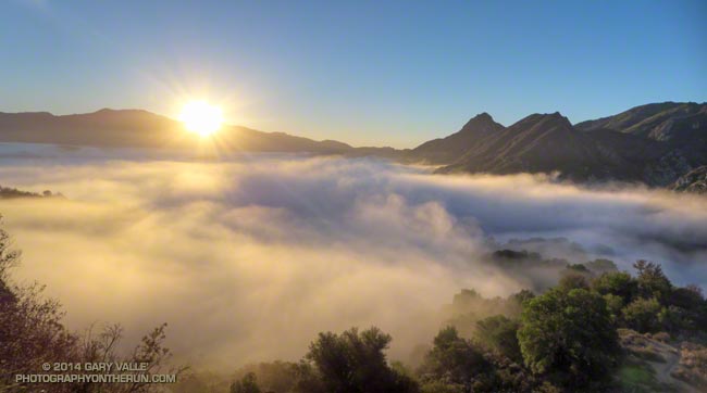
The sun rises over the shoulder of Saddle Peak illuminating a shallow layer of fog in Malibu Canyon.

The sun rises over the shoulder of Saddle Peak illuminating a shallow layer of fog in Malibu Canyon.
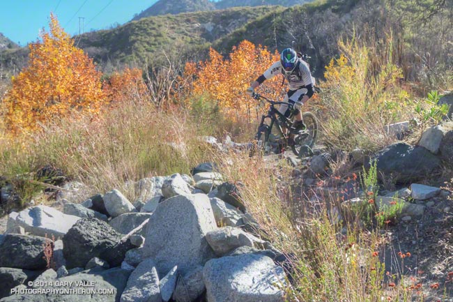
Downhill mountain biker on a technical single-track trail in the San Gabriel Mountains.
Since being acquired by Decker Outdoor Corporation in April 2013, Hoka One One has continued to innovate, improving existing designs and introducing many new designs.
Back in February when we were last talking about Hokas, I’d been running in the Mafate 2s and had just purchased a couple of pairs of Mafate 3s. The Mafate 2s were big, mega-cushioned, protective, durable and moderately heavy. I put over 1000 miles on one pair of Mafate 2s and around 300-500 miles on each of several other pairs.
The Mafate 3 improved several aspects of the Mafate design, but gained weight in the process. My Mafate 3s are more than an ounce heavier than my 13.8 oz. Mafate 2s. Heavy or not, I did a lot of training and a few races in the Mafate 3s and overall the shoes have worked well for me.
Add an ounce here and an ounce there and pretty soon you’re running in a shoe that weighs nearly a pound — or more in some circumstances. Although it hasn’t been a problem for me in drought-plagued Southern California, the Mafate 3s can become insanely heavy when wet. A friend that lives on the North Shore weighed them in at a foot-dragging 1.5 pounds each after a wet run!
The weight of the Mafate 3s and lower volume toe box were not ideal, so I started looking for an alternative. In April 2014 I got a pair of Hoka Rapa Nui 2s. The Rapa Nui 2s are a far more nimble shoe, with less cushioning, less protection, and a lot less weight than the Mafate 3. My first pair of Rapa Nui 2s weighed in at about 11.2 oz. per shoe.
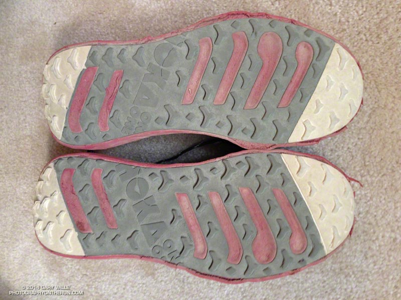
The Rapa Nui 2s fast became by favorite shoe. There are always trade-offs in design and the Rapa Nui 2s are not as durable as the Mafate 3. In normal running on dirt roads and single-track trails I usually get around 300 miles out of the Rapa Nui 2. However, a very rough and steep trail can beat up the shoes very quickly. This pair had about 160 miles on them when we did a run over Mt. Baldy and down the North Backbone trail and then descended Register Ridge on the way back to Manker Flat.
What I needed was a shoe that combined the best features of the Rapa Nui 2 and Mafate 3. And that’s why I tried the Mafate Speed. They are lightweight, protective, not over-sized, have very good cushioning, and are more durable than the Rapa Nui 2. The perfect choice for a long run, right?
I thought so. I’d never had a serious problem with any Hoka, but did with this pair of Mafate Speeds. By mile 9 of the AC100 the ankle cuff of the shoe had worn a bloody sore on my right outer ankle bone. I switched back to Rapa Nui 2s and had no more foot problems.
This experience made me wary of the Mafate Speeds, but I really liked the shoe and recently decided to try them again. And again I had the problem with the right ankle cuff digging into my ankle.
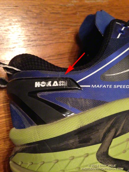
In each case the chaffing was much worse on the right ankle. Why wasn’t the left shoe digging into my ankle? After taking a closer look at the shoes it turned out the external plastic stiffener on the right shoe was much closer to the ankle collar than on the left shoe. This made the minimally-padded collar less flexible.
After I trimmed the stiffener to increase the gap, the problem was mostly resolved. I say mostly because I think the cuff could still benefit from a bit more padding. I’ll have to see how they feel on a 25+ mile run on technical single track, but I think they’ll probably be OK.
Although I’ve had this issue on both pairs of Mafate Speeds I’ve purchased, I checked the Mafate Speeds of a couple of friends and the spacing between the collar and stiffener were more or less equal on their shoes.
So for now, the Rapa Nui 2 is still my go-to shoe for races and my training time is about equally split between the Rapa Nui 2, Mafate Speed and Mafate 3. If the Mafate Speed (modified as necessary) works out OK on longer runs I’ll probably do more training and perhaps racing in the Mafate Speeds. We’ll see!
Update January 23, 2015. I’ve returned the Mafate Speeds and exchanged them for a second pair of the Hoka One One Challengers. The Challenger is very lightweight and comfortable, and it doesn’t have the ‘External TPU Heel Counter’ that (in my case) over-stiffens the ankle collar.
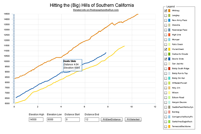
Comparison of Whitney (Trail), San Gorgonio (Vivian Creek) and San Jacinto (Devils Slide)
Updated November 12, 2014. Added Register Ridge on Mt. Baldy and the Siberia Creek Trail in Big Bear.
Southern California is noted for its foothills and mountains. It’s so hilly here that most trail runs have at least one good climb. Even if you aren’t a high mileage runner, the elevation gained on those hills can add up fast. So far this year SportTracks puts my cumulative elevation gain at about 320,000 feet.
I was curious to see how some of the “hills” in Southern California compare, so I wrote a Flash application that interactively displays the elevation profiles of a selection of SoCal ascents. Generally trails were picked that could be done in day from L.A. The selection includes some East Side Sierra ascents, routes up most of the major Southern California peaks, and some hills from some Southern California races.
The profiles and other stats are based on DEM corrected data from GPS tracks. All distances, elevations, elevation gains and elevation profiles are approximate. Elevations have been corrected and elevation gains (conservatively) calculated using SportTracks.
The Flash app is loading a lot of data, so it may take a while to load. The app is best viewed on a desktop, laptop, or tablet. It can’t be viewed on an iPad/iPhone unless a browser that supports Flash, such as Photon, is used. Here is the updated selection of elevation profiles and the selection from 2012. The “Fit Selected” button is used to fit the chart to the currently selected set of elevation profiles. The “Fit Elev/Distance” button is used to format the chart according to user specified elevations and distances.
In this selection of hills Cactus to Clouds is the longest (14.7 miles) and has the most altitude gain (10,812 feet). Register Ridge on Mt. Baldy has the steepest mile (1745 fpm) and is the steepest overall (1127 fpm). Mt. Whitney has the highest finishing elevation (14,505 feet).
Following are some additional details about each of the ascents, including the length of the climb, elevation gain, average gradient and steepest mile. The distance specified is just for climb described — not the entire run. The headings below are the shorthand name of the climb used in the legend of the app.
Whitney
Mt. Whitney via the trail from Whitney Portal.
Distance: 10.5 mi – Gain: 6657 ft – Avg Gradient: 632 fpm – Steepest Mile: 900 fpm @ mile 4.5
Requires permit. The 1991 Los Angeles Times story about Marty Hornick’s 2:08:30 ascent of Whitney via the Mountaineers Route mentions a 2:17 time via the trail. According to the China Lake Mountain Rescue Group’s Talus Pile December 2002, Issue # 126, Jason Lakey did the roundtrip via the Mountaineer’s Route in a record 3:10:07.
Related post: East Face Mt. Whitney, Tower Traverse
Langley
Mt. Langley via Army Pass from Horseshoe Meadow Cottonwood Lakes Trailhead.
Distance: 10.2 mi – Gain: 4161 ft – Avg Gradient: 408 fpm – Steepest Mile: 1275 fpm @ mile 8.8
Army Pass is often choked with snow. New Army Pass is used as an alternative. Last couple of miles is on use trails and depending on your route could involve a little scrambling.
Related post: Mt. Langley in a Day from L.A.
New Army Pass
New Army Pass from Horseshoe Meadow Cottonwood Lakes Trailhead.
Distance: 8.4 mi – Gain: 2409 ft – Avg Gradient: 274 fpm – Steepest Mile: 617 fpm @ mile 7.4
Related post: New Army Pass – Cottonwood Pass Loop
Olancha
Olancha Peak via the Sage Flat Trail and “cow driveway”.
Distance: 9.2 mi – Gain: 6213 ft – Avg Gradient: 676 fpm – Steepest Mile: 1437 fpm @ mile 8.2
Last mile or so to the summit is not on a trail and involves some scrambling up rocks.
Related post: Olancha Peak Sierra Panorama
Kearsarge Pass
Kearsarge Pass from Onion Valley.
Distance: 4.9 mi – Gain: 2610 ft – Avg Gradient: 531 fpm – Steepest Mile: 641 fpm @ mile 1.0
Various runs can be done from the pass.
Related post: Up and Over Kearsarge Pass
High Line
Mt. San Gorgonio via Momyer and San Bernardino Divide Trail.
Distance: 15.0 mi – Gain: 7146 ft – Avg Gradient: 478 fpm – Steepest Mile: 1119 fpm @ mile 4.0
Requires permit. Total distance starting/ending at Momyer is about 26 miles.
Related post: San Gorgonio High Line 2009
Momyer
The Momyer Trail to the San Bernardino Divide Trail.
Distance: 7.1 mi – Gain: 5023 ft – Avg Gradient: 707 fpm – Steepest Mile: 1119 fpm @ mile 4.0
Requires permit. Once up to the San Bernardino Divide Trail there is a choice of around ten peaks over 10,000′.
Related post: San Gorgonio High Line
Falls Creek
Mt. San Gorgonio via Momyer and Falls Creek Trails.
Distance: 15.0 mi – Gain: 6397 ft – Avg Gradient: 481 fpm – Steepest Mile: 872 fpm @ mile 1.7
Requires permit. Total distance starting/ending at Momyer is 24 miles.
Related post: San Gorgonio Mountain – Falls Creek Loop 2011
Vivian Creek
Mt. San Gorgonio via Vivian Creek Trail.
Distance: 9.4 mi – Gain: 5464 ft – Avg Gradient: 585 fpm – Steepest Mile: 920 fpm @ mile 7.7
Requires permit. This is the descent route for High Line and Falls Creek loops.
Cactus to Clouds
Mt. San Jacinto via the Skyline Trail, Round Valley Trail and San Jacinto Peak Trail.
Distance: 14.7 mi – Gain: 10812 ft – Avg Gradient: 736 fpm – Steepest Mile: 1499 fpm @ mile 7.3
Requires permit. The biggest hill in Southern California.
Devils Slide
Mt. San Jacinto from Humber Park via Devils Slide Trail, PCT and San Jacinto Peak Trail.
Distance: 7.8 mi – Gain: 4407 ft – Avg Gradient: 566 fpm – Steepest Mile: 716 fpm @ mile 2.9
Requires permit.
San Jacinto
Mt. San Jacinto from the Long Valley Tram Station via the Round Valley Trail and San Jacinto Peak Trail.
Distance: 5.4 mi – Gain: 2520 ft – Avg Gradient: 470 fpm – Steepest Mile: 709 fpm @ mile 4.4
Requires permit.
Related post: Summery San Jacinto, Smoky Tahquitz Peak
Baldy South Ridge
Mt. Baldy from the Village via Bear Canyon and South Ridge on the Old Mt. Baldy Trail.
Distance: 6.8 mi – Gain: 5811 ft – Avg Gradient: 850 fpm – Steepest Mile: 1273 fpm @ mile 2.1
Related post: Up & Down Mt. Baldy’s South Ridge
Baldy Run to the Top
Mt. Baldy from base of ski lift parking lot.
Distance: 6.9 mi – Gain: 3868 ft – Avg Gradient: 558 fpm – Steepest Mile: 799 fpm @ mile 4.9
Last 0.6 mi to summit is approximately 1090 fpm.
Related post: Mt. Baldy Run to the Top 2009
Baldy Ski Hut
Mt. Baldy from Manker Flat via the Baldy Bowl Trail — aka the Ski Hut Trail.
Distance: 4.4 mi – Gain: 3883 ft – Avg Gradient: 891 fpm – Steepest Mile: 1201 fpm @ mile 2.8
Related post: Back to Baldy
Baldy Register Ridge (New)
Mt. Baldy from Manker Flat via the Register Ridge Trail.
Distance: 3.5 mi – Gain: 3909 ft – Avg Gradient: 1127 fpm – Steepest Mile: 1745 fpm @ mile 0.9
SFBadenPowell
Mt. Baden-Powell from South Fork Campground via Manzanita Trail and PCT. Vincent Gap is at about mile 5.75.
Distance: 10.0 mi – Gain: 5074 ft – Avg Gradient: 510 fpm – Steepest Mile: 805 fpm @ mile 8.6
Part of a 23.5 mile loop from Islip Saddle
Related post: San Gabriel Mountains Running Adventure
Siberia Creek (New)
The Siberia Creek climb starts at Bear Creek and climbs to Forest Service Road 2N11 via the Siberia Creek Trail and a short segment of the Champion Lodgepole Trail. It is part of the Kodiak 100M and 50M courses.
Distance: 6.9 mi – Gain: 3008 ft – Avg Gradient: 435 fpm – Steepest Mile: 698 fpm @ mile 1.4
Related post: Kodiak 50 Mile 2014
Holy Jim
Holy Jim Trail from Trabuco Canyon to Santiago Peak. Was part of Twin Peaks 50K.
Distance: 8.0 mi – Gain: 3921 ft – Avg Gradient: 489 fpm – Steepest Mile: 691 fpm @ mile 5.3
Related post: Blue Skies and Sunshine for the 2010 Twin Peaks 50K & 50M Trail Runs
Wilson Trail
Mt. Wilson from Sierra Madre via the Mt. Wilson Trail. Orchard Camp is at about mile 3.5.
Distance: 7.1 mi – Gain: 4720 ft – Avg Gradient: 662 fpm – Steepest Mile: 925 fpm @ mile 4.0
Edison Road (In 06/08/2012 selection.)
Edison Road from the West Fork San Gabriel River to Angeles Crest Highway at Shortcut Saddle. Part of Mt. Disappointment 50K.
Distance: 5.5 mi – Gain: 2027 ft – Avg Gradient: 372 fpm – Steepest Mile: 520 fpm @ mile 3.3
Related post: Mt. Disappointment 50K 2011 Notes
Kenyon Devore
Gabrielino and Kenyon Devore Trails from West Fork to Mt. Wilson. Part of Mt. Disappointment 50K.
Distance: 4.9 mi – Gain: 2622 ft – Avg Gradient: 532 fpm – Steepest Mile: 801 fpm @ mile 1.9
Related post: Trail Work and Tree Rings
SaddlePeakMalibuCyn (In 06/08/2012 selection.)
Saddle Peak from Piuma Road near Malibu Canyon via the Backbone Trail.
Distance: 6.3 mi – Gain: 2350 ft – Avg Gradient: 372 fpm – Steepest Mile: 680 fpm @ mile 4.9
Related post: Bulldog Loop or Saddle Peak Out & Back?
Bulldog
Bulldog Lateral and Motorway from Crags Rd. to Castro Motorway. Part of Bulldog 25K/50K, XTERRA Malibu Creek Challenge and other races.
Distance: 3.4 mi – Gain: 1727 ft – Avg Gradient: 514 fpm – Steepest Mile: 732 fpm @ mile 2.0
Related post: Bulldog 50K 2010 Notes
CorriganvilleRockyPk (In 06/08/2012 selection.)
Corridor Trail from Corriganville to Rocky Peak Rd. Then Rocky Peak Rd to high point near Rocky Peak. Part of Bandit 15K/30K/50K. Does not include initial loop in Corriganville. 50K descends to Santa Susana Pass.
Distance: 3.3 mi – Gain: 1547 ft – Avg Gradient: 464 fpm – Steepest Mile: 836 fpm @ mile 0.6
Related post: Bandit 30K 2009
SantaYnezEagleRock (In 06/08/2012 selection.)
Eagle Rock from Vereda De La Montura via the Santa Ynez Canyon Trail, Musch Trail and East Topanga Fire Road.
Distance: 5.6 mi – Gain: 1292 ft – Avg Gradient: 230 fpm – Steepest Mile: 643 fpm @ mile 1.0
Related post: Clouds, Canyons and Wildflowers
TemescalBackbone (In 06/08/2012 selection.)
Temescal Canyon to the Backbone Trail Junction via Temescal Canyon and Temescal Ridge Trails.
Distance: 5.4 mi – Gain: 1709 ft – Avg Gradient: 318 fpm – Steepest Mile: 760 fpm @ mile 0.8
Related post: Will Rogers – Temescal Loop
Las Llajas (In 06/08/2012 selection.)
Las Llajas Canyon from near Evening Sky Drive to high point above oil field. Part of Bandit 30K/50K
Distance: 4.9 mi – Gain: 1418 ft – Avg Gradient: 290 fpm – Steepest Mile: 625 fpm @ mile 3.1
Related post: Bandit 50K 2011 Notes
Mt. Baldy from the North Backbone Trail
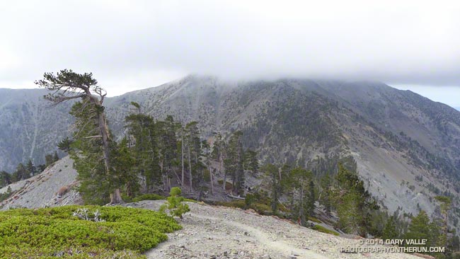
According to my car’s thermometer the temperature in the west San Fernando Valley was 86 degrees. To the east a large patch of middle-level clouds had morphed into a large lenticular cloud. Over the course of a few minutes the wave cloud continued to transform, dividing into a train of alto-cumulus waves.
I just shook my head. A few hours earlier and 60 miles away, I had been freezing. The plan had been to do a “Baldy Over the Top” run to the old juniper on the north side of Pine Mountain. Around 8:45 am, as running partner Ann Ongena and I crested the cloud-capped, 10,064′ summit of Mt. Baldy, the wind chill temperature had been around 30 degrees. The air temperature was in the low 40s, but with the wind blowing at least 40 mph and gusting to over 50 mph it had been brutally COLD. Especially in running shorts.
Spending zero time on the summit, we waved to the hikers huddled in the rock windbreaks as we sprinted by. The hope had been that the wind (and temperature) would moderate as we descended the North Devil’s Backbone on the back side of Baldy.
It didn’t. Wind-driven clouds continued to sweep past the ridge as we ran down the steep path. At the first opportunity we stopped in the wind shadow of a clump of stunted lodgepole pines and put on wind/rain shells. The shells were three ounces of magic — without them it would have been foolhardy to continue.
As we descended to the Baldy – Dawson Saddle and then climbed up to Dawson Peak I kept looking back over my shoulder to the cloud-shrouded summit of Mt. Baldy. Were there more clouds? Was the ceiling lower? Was there more vertical development?
The day before I had checked the forecast from the NWS and the forecast models. A dissipating cold front was approaching the area from the north, but wasn’t expected to pass through until sometime tonight. No measurable rain was forecast for the Los Angeles area. The last time I had checked no clouds had been forecast for Saturday morning — but there they were. I had expected some southwesterly winds ahead of the front, but nothing like this.
I didn’t like being on the back side of the mountain in potentially bad weather knowing that “home” was on the front side. We had just enough gear to deal with the current conditions. I didn’t think it was very likely, but if the weather deteriorated…
Many of the incidents that occur in the outdoors are the result of a series of misjudgments. If you’re already on the edge it’s usually best to call it before things get REALLY complicated.
And that’s exactly what we did. After descending a short distance down the ridge from Dawson Peak we turned around. Even if the outing was going to be a bit shorter than planned, it was still going to be an outstanding hike and run in extraordinary conditions with over 6000 feet of elevation gain.
It was just as windy, cold and cloudy on the second trip over the top of Baldy as it had been on the first and we spent about the same number of milliseconds on the summit before picking up the Devil’s Backbone trail and running down.
Some related posts: Mountain Weather, Atmospheric Dynamics
With this year’s El Nino developing in fits and starts and drought-plagued California clinging to hopes of an above average snowpack, a little September snow is a big deal, even if it’s just a dusting.
The first low pressure system of Fall resulted in significant rain in many areas of Central and Northern California, with amounts falling off quickly to the south. According to the NWS, Redding recorded over 3 inches of rain; Red Bluff nearly 2.5 inches; South Lake Tahoe 1.8 inches; Downtown Sacramento and San Francisco both recorded about 0.5 inch.
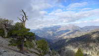
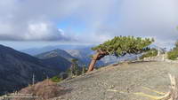
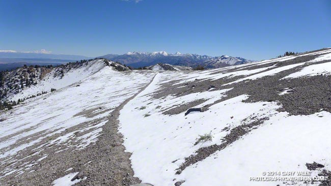
For a rain-starved, heat-desiccated Southern Californian it was great to get out and play in the snow. I had a window of about three hours to do a run and the run/hike up San Joaquin Ridge from Minaret Summit was superb!
Here are a few photos from the run.