Category Archives: nature|wildlife

Kingsnake Along the Garapito Trail

California mountain kingsnake along the Garapito Trail in the Santa Monica Mountains

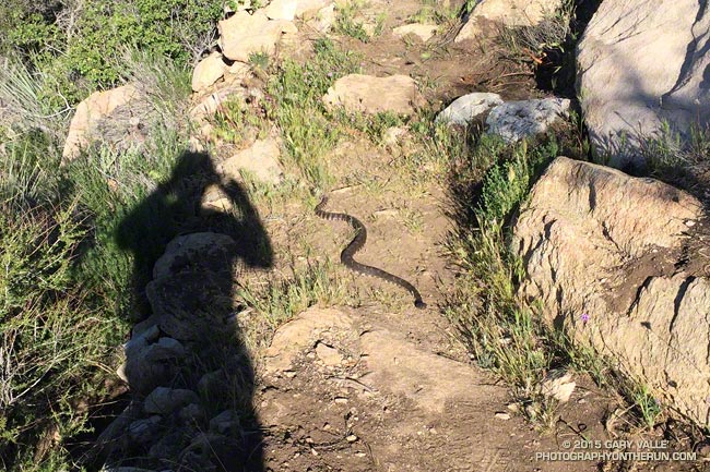
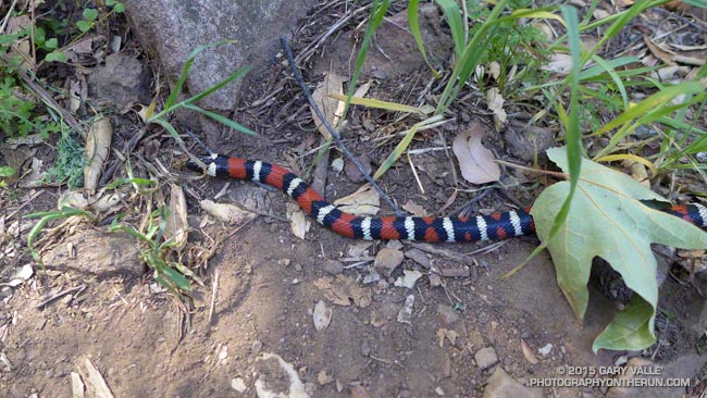
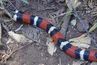
The patterned colors of a mountain kingsnake are hard to miss. The snake’s white-black-red-black-white triads attract attention in just about any habitat. (The amount of red can vary in an individual as well as subgroup.)

San Diego mountain kingsnake along the Garapito Trail
San Diego mountain kingsnake

Traditionally California mountain kingsnakes (Lampropeltis zonata) have been grouped into several subspecies according to subtle and variable pattern characteristics.

The kingsnake in the title photograph appears to belong to the San Diego mountain kingsnake pattern class (Lampropeltis zonata pulchra). The broken white ring on the head is common in this subgroup in the Santa Monica Mountains.

San Bernardino mountain kingsnake on Pleasant View Ridge in the San Gabriel Mountains
San Bernardino mountain kingsnake

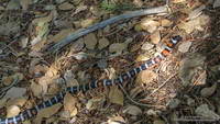
This mountain kingsnake, photographed on Pleasant View Ridge in the San Gabriel Mountains, likely belongs to the San Bernardino mountain kingsnake pattern class, Lampropeltis zonata parvirubra.

Study of California mountain kingsnakes’ mitochondrial DNA (E. A. Myers, et. al., 2013) conservatively supports separate northern and southern species and potentially two lineages within the southern group.

California kingsnake in Upper Las Virgenes Canyon Open Space Preserve
California kingsnake

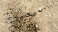
Mountain kingsnakes aren’t the only kingsnake found in the Los Angeles area. This California kingsnake (Lampropeltis getula californiae) was photographed at Ahmanson Ranch a couple of weeks ago. When I approached the snake, it immediately became defensive and started rapidly vibrating its tail. This behavior is often described as mimicking a rattlesnake, but could also predate the development of rattles in rattlesnakes.

For more info on the reptiles and amphibians of California see the californiaherps.com web site.

The Rattlesnakes Are Blooming

Rattlesnake on the PCT east of San Francisquito Canyon.

Although we are still experiencing a record-breaking drought, this rain season did provide a little short term relief to plants and wildlife. Compared to last year rainfall is up 27% at Los Angeles, 39% at Santa Barbara, 57% at LAX and 63% at Camarillo/Oxnard according to NWS data.

The increase in rainy season precipitation dramatically increased plant growth, the abundance of wildflowers, and temporarily increased the availability of key resources to wildlife.

Another thing it seems to have increased is the number of rattlesnakes. Over the past two years I have seen maybe two rattlesnakes total on my runs in the Santa Monica Mountains, San Gabriel Mountains, and in the Big Bear area and on San Gorgonio Mountain. In the Ahmanson Ranch – Cheeseboro area I’ve seen none.

With the increase in rainfall this season that has changed. The title photo was taken on the Leona Divide 50/50 course March 28. That day I encountered two rattlesnakes and talked to a runner that had seen three on the course the previous weekend. From March 26 to April 2 I encountered rattlesnakes on three out of four runs. Two of those were at Ahmanson and it seemed everyone I talked to on the trail was seeing rattlesnakes.

Hard to see rattlesnake on the PCT a few miles west of Bouquet Canyon.
See the rattlesnake? Click for larger view.

There has also been an increase in the number of encounters with non-venomous snakes as well. I’ve seen a number of gopher snakes and a California striped racer. Friends have mentioned seeing a ring-necked snake and California kingsnake.

Since the weather has cooled I haven’t encountered any rattlesnakes, but have seen their tracks. When I run, especially on single-track trails, my snake radar is on and I’m definitely on the lookout for the hard-to-see beasts.

Some related posts: Southern Pacific Rattlesnake on the Burkhart Trail, Southern Pacific Rattlesnake, Big Southern Pacific Rattlesnake at Ahmanson Ranch

Tamalpais Trail Run

Running ahead of me at a brisk pace, Brett suddenly stopped and turned, gesturing for me to slow and be quiet. On the shaded trail ahead I could see something large and brown hunched over on the trail. It took a moment to realize that it was a big male turkey in full regalia.

We were on Mt. Tamalpais, and about a half-mile into an afternoon run from the Bootjack parking area in Mt. Tamalpais State Park. This scenic loop was the first of several runs over a too-short Bay area weekend visit. One of the innumerable loops and variations in and near the Park, our route included segments of the Old Mine, Rock Spring and Matt Davis Trails.

According to this November 2012 article in the Marin Independent Journal the turkeys were introduced into Marin County in 1988 by Fish & Game to provide hunting opportunities on private land. They have since become a nuisance and usurp resources from native species. During the birds’ mating season they have reportedly frightened hikers and bikers. (I might have scoffed at that statement before seeing the size of this tom.)

It was a warm in the sun, cool in the shade afternoon with the temperature in the mid-70s. Earlier in the week an offshore flow had pushed temperatures in the Bay area well into the 90s. The heatwave produced numerous record highs, with the temperature at San Francisco Airport reaching over 90 degrees on Tuesday and Wednesday. The remote automated weather station (RAWS) on Middle Peak can be used to get an idea of the weather on Mt. Tam.

Today the winds were onshore, but the visibility was still very good. The twin summits of Mt. Diablo could be clearly seen across the bay, about 40 miles away. Mt. Diablo would be the site of one of tomorrow’s runs. Rumor had it the rare Mt. Diablo fairy lantern was blooming, and Brett had planned a run on Diablo that included North Peak, Bald Ridge and Eagle Peak.

Here are a few photos from today’s run on Mt. Tam. More info can be found on the Mt. Tamalpais State Park and the Friends of Mt. Tam web sites. This State Park brochure includes a trail map.

Williamson Rock – Angeles National Forest

Williamson Rock - Angeles National Forest

Update 8/21/18. Nearly 13 years after the closure of Williamson Rock and a key segment of the Pacific Crest Trail, the Forest Service has released a Draft Environmental Impact Statement for the Williamson Rock Project. The public comment period is from July 27 to September 10, 2018. For additional information see the Forest Service Williamson Rock Project page and the Access Fund page REOPEN WILLIAMSON ROCK TO CLIMBING!

Update 12/22/13. New Williamson Rock/PCT scoping letter, dated 12/18/13, from Angeles National Forest to “consider resuming recreation opportunities in the currently closed area, in and around Williamson Rock.”

————

The following was posted 10/5/12.

It’s been nearly seven years since the Forest Service “temporarily” closed approximately 1,000 acres in the upper Little Rock Creek drainage in the San Gabriel Mountains in order to protect critical habitat of the mountain yellow-legged frog (MYLF). The closed area includes Williamson Rock, a once-popular rock climbing area, and a key 3.5 mile segment of the Pacific Crest Trail between Eagle’s Roost and the Burkhart Trail.

As might be expected when an issue is complex and involves several concerned parties, resolution has been painfully slow. Williamson Rock is a large formation encompassing many smaller climbing sub-areas. The majority of these areas are outside of MYLF habitat. The Recreational Development Alternative protects MYLF habitat while allowing recreational access to other areas of the formation. (See the Access Fund Williamson Rock page for more information.)

Last year United States District Judge Marilyn Hall Patel (Northern District of California) ordered Angeles National Forest to “halt all construction and close access to the Williamson Rock Area of the Angeles National Forest until the Amended Biological Opinion and accompanying ITS is filed and the matter is reviewed by the parties and the court.” It is unclear how much time will be required to complete these filings and subsequent reviews.

In the meantime, a recent article in the Los Angeles Times suggests there might be some reason for optimism concerning the fate of the MYLF, with “the fist-sized amphibians breeding in numbers not seen in decades.”

The title photograph is from last Sunday’s Pleasant View Ridge run.

Celebrating the 10th Anniversary of the Acquisition of Ahmanson Ranch

Valley oaks and cirrus clouds near sunset at Ahmanson Ranch

Today those instrumental in the acquisition of Ahmanson Ranch and supporters of the open space area gathered at the park — now Upper Las Virgenes Canyon Open Space Preserve — to celebrate its purchase. For more on the festivities see this article in the Simi Valley Acorn.

I’ve been running at Ahmanson Ranch for more than ten years and have spent hundreds of hours in the open space area. Following are a few photographs, stories and wildlife encounters from these runs.

 – Northern Harrier Turning to Strike

 – Moonrises and Sunsets

 – Sunset Shower

 – Ahmanson Ranch Moonrise

 – Red-winged Blackbird Song Spread

 – Racing the Sun, Catching the Moon

 – Coyote Tag and Coyote Tag II

 – Southern Pacific Rattlesnake and Big Southern Pacific Rattlesnake

 – Ahmanson Blue Oak

 – Astronomical Trail Running

 – Ahmanson Ranch Trail Runs

 – September & October are Tarantula Months!

 – Southern California Greenscape

 – A Sunset and Moonrise

 – Dealing With Drought

 – Lenticular Wave Clouds

Signs of Winter

 – King of the Hill

Comet PanSTARRS and the Crescent Moon

The title photograph is from a run at Ahmanson Ranch earlier this November.

Watch and Wonder

Crown-sprouting laurel sumac in Pt. Mugu State Park following the Springs Fire.

Trying to understand the behavior of wildlife can be perplexing, particularly when it involves human interaction. Sometimes I just shake my head and wonder what an animal is thinking.

I was in the middle of a 13.5 mile loop in Pt. Mugu State Park, chugging up the Old Boney Trail in the Boney Mountain Wilderness, about 2.5 miles past its junction with the Blue Canyon Trail.


From time to time I’ve been checking the progress of recovery in Springs Fire burn area. Ecologically the area is very complex and as a result of the varied terrain, habitats, vegetation patterns, soil moisture and burn severity, the rate of recovery has also been varied.

The recovery has been further complicated by the season of the fire — just before Summer — and by below average rainfall. Taking into account the unusual circumstances, the sprouting of sycamore, oak, walnut, bay, red shanks, laurel sumac, toyon, mule fat and other plants has been surprisingly robust.

The stretch of the Old Boney Trail I was on now had been severely burned. It was along a steep, rocky canyon that still looked quite barren. Many chaparral plants sprout from surviving roots following a fire, but some plants such as the bigpod Ceanothus in this area must regrow from seeds which sprout following Winter rains.

With the lack of vegetation I was a little surprised to see a California Towhee land on the rocky trail a few feet ahead of me.

The California Towhee lives in the chaparral and I see them frequently on trail runs. It is about as nondescript as a bird can be — gray-brown and little smaller than a dove. They have a peculiar habit of emerging from the brush, scurrying a few feet along a trail just ahead of a hiker or runner, and then darting back into the brush.


Inexplicably this particular bird carried this behavior to the extreme, scampering along the trail just ahead of me for more than 2 minutes, eventually pausing on some rocks along the trail and watching me pass. The time from the first picture of the bird on the trail to the last was 2 minutes 14 seconds. That’s one-Mississippi, two-Mississippi, all the way up to one hundred thirty-four-Mississippi.

I often see towhees in pairs and sometimes with rabbits when both are foraging. The rabbit acts as an early warning device for the bird and vice versa. Did the towhee see me as a really big rabbit? All I could do is watch the bird and wonder.

Some related posts: Chasing Towhees and Other Rainy Day Activities, Coyote Tag, Coyote Tag II, Hawk, Bobcat and Rabbit